
Thunderstorms Training Over New Jersey Flash Flood Watch Tonight
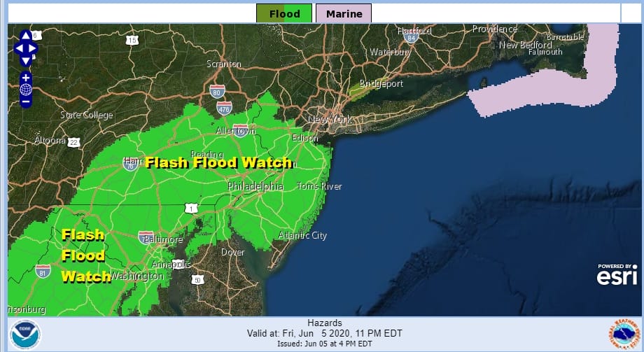
The thunderstorms of the last few days and nights have saturated the ground in many areas. After a warm humid day an approaching upper trough is triggering off thunderstorm activity but they seem to be forming over one area and “training” over New Jersey and Southeastern Pennsylvania. This is where we have a band that sets up and doesn’t move very much and thunderstorms form, die and then reform over the same area. This will continue into tonight and that is why we have flash flood watches up for Central and South Jersey and Southeastern Pennsylvania. Rainfall amounts will be thunderstorm dependent with local amounts of 2 inches or more possible but the variation will be rather wide.
SATELLITE

REGIONAL RADAR

Look at the satellite picture and the regional radar. There is a stick of clouds running northeast southwest from Southern New England to Northeast Virginia and now we are seeing thunderstorms developing inside that band. The cells are moving northeast but the band isn’t moving much at all right now. Look for showers and thunderstorms to spread further north reaching into areas from Northern New Jersey and the Hudson Valley to Southern New England while continuing over Central and South Jersey and Southeast Pennsylvania south into Virginia and Maryland.
LOCAL RADAR BINGHAMTON

LOCAL RADAR PHILADELPHIA


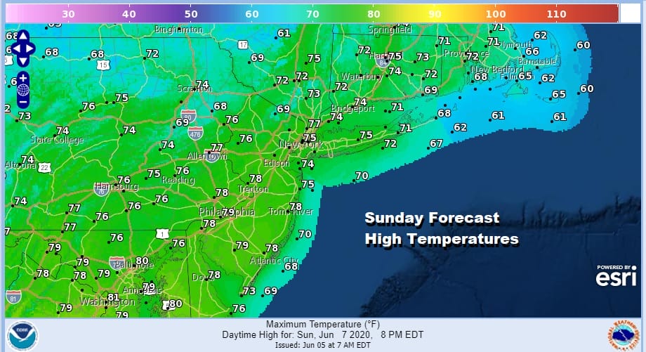
This should eventually come to an end overnight. Weather conditions should improve Saturday with some sunshine returning and highs in the 80s. Humidity levels will start to come down once a dry line moves through in the afternoon. Perhaps there could be an isolated shower or thunderstorm Saturday. The chance is low. We should clear out nicely Saturday night. Sunday will be nice and sunny with highs mostly in the 70s.
Next week looks dry and nice through Wednesday with the next chance for showers on Thursday. This system for Thursday looks unimpressive at the moment and there is a chance it could weaken before it gets here. Sunny skies Monday will bring highs in the 70s. Sunshine continues Tuesday and Wednesday with highs reaching into the 80s both days.
BE SURE TO DOWNLOAD THE FREE METEOROLOGIST JOE CIOFFI WEATHER APP &
ANGRY BEN’S FREE WEATHER APP “THE ANGRY WEATHERMAN!
MANY THANKS TO TROPICAL TIDBITS FOR THE USE OF MAPS
Please note that with regards to any severe weather, tropical storms, or hurricanes, should a storm be threatening, please consult your local National Weather Service office or your local government officials about what action you should be taking to protect life and property.


