The Better Weekend Day Before Rain Tonight Sunday
Our weekend is underway and today is going to be a cold day. We are starting the day off with sunshine but clouds lay to our south and southwest as low pressure begins to take hold in the low Mississippi Valley and tracks to the northeast. Look for sunshine to fade slowly away this afternoon. Highs will be just into the 40s. Nothing is showing up yet on the regional radar but we will start seeing rain appear soon enough to our southwest and moving northeast.
SATELLITE

REGIONAL RADAR

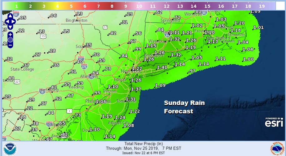
Tonight we see rain develop. It should arrive in Southeastern Pennsylvania and Southern New Jersey around 7pm and reach NYC before midnight. It rains into Sunday morning but by daybreak the back edge will be lifting northeastward as the low tracks virtually right on the coast.

At least the rain should be mostly over with South Jersey & Southeastern Pennsylvania by daybreak and perhaps by mid morning at NYC. There could be some back edge clouds and precipitation lingering in the Hudson Valley and Southern New England during the early afternoon before the low moves away to the northeast. Temperatures will likely be in the raw 40s in most places.
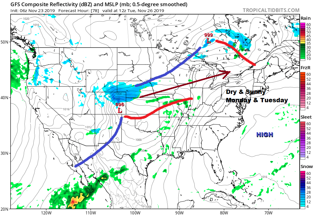
Thanksgiving Week starts of nice for Monday and Tuesday. Temperatures in fact will be reasonable for this time of year. Sunshine looks to be with us for both days with highs in the upper 40s and lower 50s Monday and into the 50s on Tuesday. That map above shows minor issues around the country Monday and Tuesday and there should be minimal travel issues on those two days.
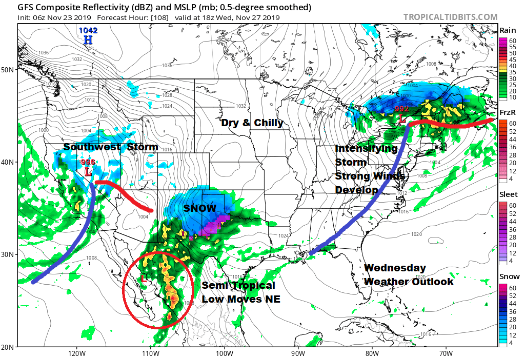
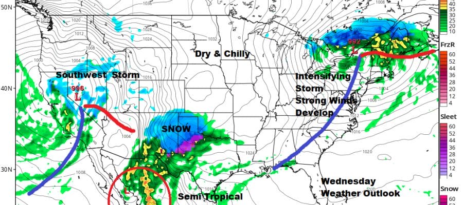
Wednesday presents travel issues and an interesting situation in New Mexico and Northwest Texas. A semi-tropical low comes off the Pacific into Mexico and runs into cold air and the chance for snow and ice is possible. Also the rest of the Southwest will be dealing with a developing storm. In the Northeast and intensifying storm moving east across Southern Canada/ Northern New England will turn on the wind machine in the Middle Atlantic and Northeast later Wednesday and continuing right through Thanksgiving day. Wednesday for most of our area will just see clouds and maybe a passing shower with highs in the 50s. Colder but dry air comes in Wednesday night. Thanksgiving day will be windy with Northwest winds of 15 to 30 mph with gusts possibly to 40 mph or more at times. This is going to create parade issues because balloons don’t like wind. Thanskgiving will be dry with some sunshine with highs just into the 40s. No issues are forecast for Friday with some sunshine and still windy at times with highs again just into the 40s. Colder areas north and west of the coast may not get out of the 30s on either day. Next weekend Saturday looks dry and cold and the wind may finally start to ease a bit. Some questions begin to rise for Sunday as low pressure moves east and reacts to blocking to our east out in the Atlantic. We will address the long range which is looking rather interesting for the start of December later today on our Patreon Platform.
BE SURE TO DOWNLOAD THE FREE METEOROLOGIST JOE CIOFFI WEATHER APP &
ANGRY BEN’S FREE WEATHER APP “THE ANGRY WEATHERMAN!
MANY THANKS TO TROPICAL TIDBITS FOR THE USE OF MAPS
Please note that with regards to any severe weather, tropical storms, or hurricanes, should a storm be threatening, please consult your local National Weather Service office or your local government officials about what action you should be taking to protect life and property.


