Temps Warm Up Next Few Days Ahead of Weather Fronts
& Storm Systems Later This Week

Temps Warm Up Next Few Days Ahead of Weather Fronts
& Storm Systems Later This Week
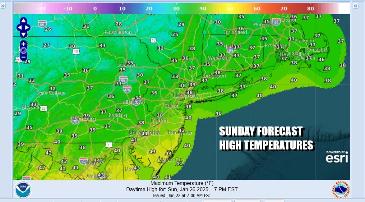
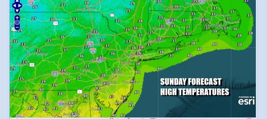
We have finally made it to the day where temperatures will rise above freezing for everyone. The cold air mass of the last 2 days is now offshore and the winds went westerly overnight. That kept temperatures from falling into the single digits and teens which was commonplace over the last two days. Instead most lows were in the 20s and that sets up for a nice launching pad today. Skies should be no worse than partly sunny as upper troughs to the north swing through with patchy clouds from time to time. High temperatures this afternoon will reach the upper 30s and lower 40s just about everywhere.
SATELLITE WITH LIGHTNING STRIKES

WEATHER RADAR

There are some snow showers to the north in the westerly flow but those should fall apart as the day wears on and they are not an issue except for Northeast Pennsylvania and the Catskills for a short period of time today. Slightly colder air comes in tonight and most lows will be in the teens inland and low to mid 20s along the coast and warmer urban areas under a partially clear sky.
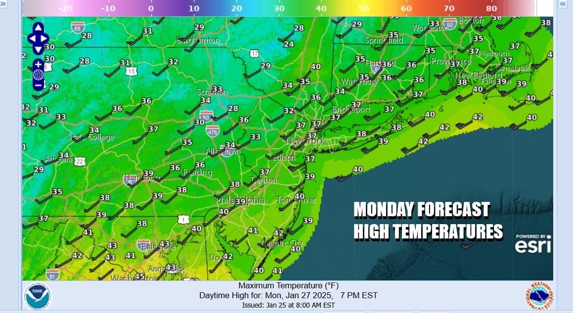
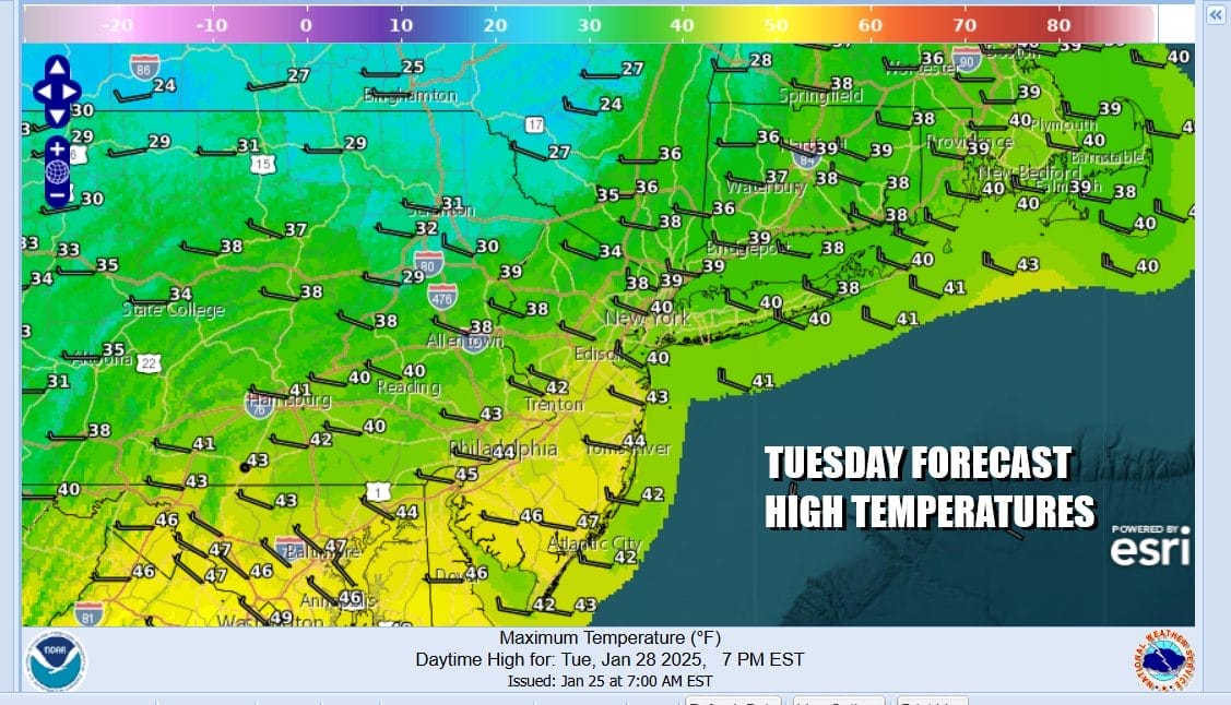
The westerly flow aloft continues Monday and Tuesday with no worse than partly sunny skies both days. There is an upper trough that will swing through late Tuesday. We will likely see snow showers and snow squalls on the radars Tuesday to the north but they should fall apart as they reach the coast. Highs both Monday and Tuesday will be in the upper 30s and lower 40s.
Wednesday sees low pressure moving southeast from the Great Lakes into Western NY and then taking a track across New England. The low redevelops off the coast of Cape Cod and strengthens and this brings warm air ahead of it Wednesday and a shot of colder air behind it for Thursday and Friday. The northerly track will keep any snow to the north though there probably will be some clouds around.

Depending on how much sun we get Wednesday as there will be more across Southern New Jersey and points south; less NYC and points north, most highs will be in the 40s. Then it will turn colder once the low heads offshore and a dry cold front passes. The models have changed somewhat overnight as they do not bring a big shot of cold air southward. Rather it spreads high pressure across New England and Eastern Canada. While it will be cold and dry Thursday and Friday, temperatures will not be unreasonably cold. Highs will be back to the upper 20s to mid 30s Thursday and low to middle 30s Friday.
BE SURE TO DOWNLOAD THE FREE METEOROLOGIST JOE CIOFFI WEATHER APP &
ANGRY BEN’S FREE WEATHER APP “THE ANGRY WEATHERMAN!
MANY THANKS TO TROPICAL TIDBITS FOR THE USE OF MAPS
Please note that with regards to any severe weather, tropical storms, or hurricanes, should a storm be threatening, please consult your local National Weather Service office or your local government officials about what action you should be taking to protect life and property.


