Temperatures Still Cold But Not Extreme Back to Average Sunday & Monday

Temperatures Still Cold But Not Extreme Back to Average Sunday & Monday
This morning was the warmest morning of the week relatively speaking of course. Lows this morning were in the teens to near 20 urban areas and coast. Single digits inland while the coldest spots well inland in areas of deeper snow cover were near or slightly below zero. At least the trend is higher. An upper trough ahs passed and low pressure is well offshore. This keeps it colder than normal today with skies no worse than partly sunny. High temperatures today will be in the upper 20s to lower 30s which is still about 10 degrees below where we should be for this time of year.
SATELLITE WITH LIGHTNING STRIKES

WEATHER RADAR

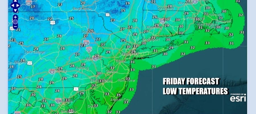
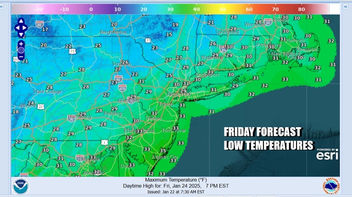
Lake effect snow continues to show up on the radars north and west in North Central and Southwestern NY but that obviously not an issue here. Tonight we will see lows in the single digits to mid teens under a clear sky. Saturday is going to be cold but with sunshine. Highs will be in the upper 20s and lower 30s.

Saturday is another cold day but we will have plenty of sunshine with highs reaching the upper 20s to lower 30s. Then the cold air moves out and we will see winds turn more westerly Sunday. That will allow temperatures to bounce nicely higher and we will have a sunny Sunday with highs reaching above freezing for the first time in a week. Most highs will be in the upper 30s to even some lower 40s in warm spots.

We are going to be under a northwest flow next week and there are 2 systems in that northwest flow that will be moving through the Northeast US. Monday we see another day of sunshine and a west wind. Highs will be in the upper 30s and lower 40s. A cold front will approach and move through Tuesday. A second system will dive southeast from the Western Great Lakes and then develop and move offshore Wednesday night into Thursday morning.

A the moment we are a little skeptical about this low taking a more southern route since models do like to show that in the long range and then ultimately they wind up tracking through upstate NY and New England but we will keep an open mind given that the northwest flow is rather strong. It will take a strong short wave to dig southward and pull off a southern track. Ahead of this late Tuesday a sharp upper trough could set off a few snow showers Tuesday evening and perhaps even a heavier snow squall. Temperatures will be trend below average late Tuesday through the rest of next week.
BE SURE TO DOWNLOAD THE FREE METEOROLOGIST JOE CIOFFI WEATHER APP &
ANGRY BEN’S FREE WEATHER APP “THE ANGRY WEATHERMAN!
MANY THANKS TO TROPICAL TIDBITS FOR THE USE OF MAPS
Please note that with regards to any severe weather, tropical storms, or hurricanes, should a storm be threatening, please consult your local National Weather Service office or your local government officials about what action you should be taking to protect life and property.


