Temperatures Slowly Bounce Higher Next 2 Days Severe Weather Risk Thursday

Temperatures Slowly Bounce Higher Next 2 Days Severe Weather Risk Thursday
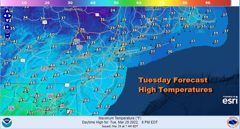
Most lows this morning were in the low to mid 20s with upper teens in cold spots. We continue to run well below average today though we will see temperatures bounce a little bit. Yesterday most places struggled just to get to the 30 degree mark making it a day where temperatures were 20 to 25 degrees below average. Today it will be more like 10 to 15 degrees below average. High pressure is along the Mid Atlantic coast. The wind will settle down, and temperatures today should make it back into the 40s in most places. We should enjoy a good deal of sunshine though some patchy high clouds could come into the mix later this afternoon and evening.
SATELLITE

WEATHER RADAR

A warm front will be setting up to our south tonight and Wednesday and it will slowly move northward. Clouds will increase later tonight as temperatures drop to the mid and upper 20s with cold spots down in the teens to near 20 while skies are clear.

Wednesday a warm front comes up from the southwest and ahead of it we will see clouds and the chance for a rain or even a snow shower inland during the morning. Highs will be in the 40s but note 50s show up in Southern New Jersey south and west and that marks the leading edge of very warm air that will be surging up the East coast Thursday.

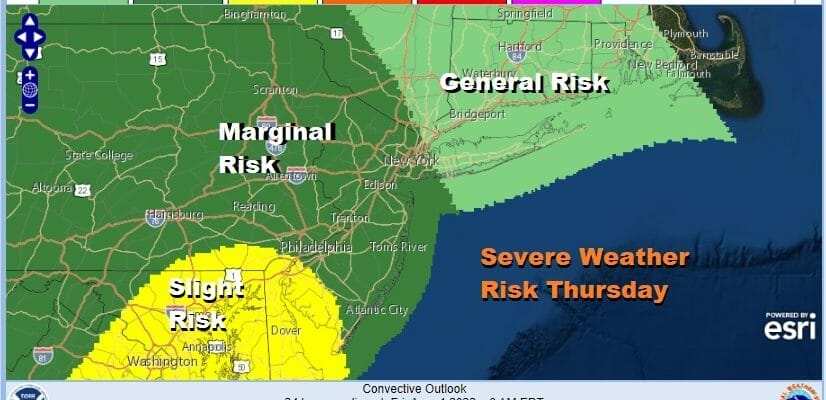
A strong cold front heads our way on Thursday. This front will begin to produce severe weather tonight across the Southern Plains to the Middle Mississippi Valley. Wednesday we could see a widespread regional outbreak in the Central Gulf States. Then attention shifts to the East Coast Thursday.
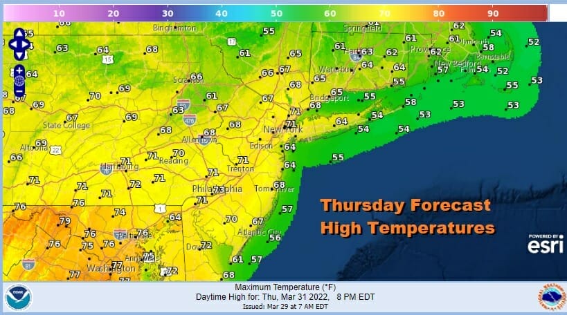
The jump will be large from Wednesday as temperatures jump 25 to 30 degrees higher. Highs will reach the 70s away from the ocean with 60s into Southern New England and mid to upper 70s possible south and west of Philadelphia. The approaching cold front brings severe weather risk Thursday per the Storm Prediction Center.

Where the marginal and slight risk wind up will depend on the warm front and how far north it gets. There has been a general trend of the SPC upping the risk area as we get closer to the actual day. We do have a strong upper trough swinging eastward and driving impressive dynamics to the coast. I would not be surprised to see the risk areas extended further north. In the meantime before showers and thunderstorms arrive we will have clouds and sun and a gusty wind on Thursday with showers and thunderstorms late in the day into Thursday night. Once the front passes weather improves Friday and into the start of the weekend. While temperatures will turn colder, the next air mass is nothing like the one we just had so temperatures should be colder but more reasonable over the weekend. Saturday looks dry but Sunday could be cloudy with the risk for some rain as a weather system tracks across the MId Atlantic states and offshore.
BE SURE TO DOWNLOAD THE FREE METEOROLOGIST JOE CIOFFI WEATHER APP &
ANGRY BEN’S FREE WEATHER APP “THE ANGRY WEATHERMAN!
MANY THANKS TO TROPICAL TIDBITS & F5 WEATHER FOR THE USE OF MAPS
Please note that with regards to any severe weather, tropical storms, or hurricanes, should a storm be threatening, please consult your local National Weather Service office or your local government officials about what action you should be taking to protect life and property.


