
Sunshine Returns But So Does Smoke Cold Fronts Moving Along Wednesday Friday

Sunshine Returns But So Does Smoke Cold Fronts Moving Along Wednesday Friday

We did get a break from the Canada wildfire smoke for a few days but now that a cold front has passes and winds have turned west and northwest again in the upper atmosphere, we can look forward to some plumes of smoke to be moving through Eastern Pennsylvania to Southern New England in the coming days, though the intensity of these plumes remains to be determined. The satellite/dust loop shows those areas in the shades of purple and orange moving around an upper air storm over the Northern Great Lakes.
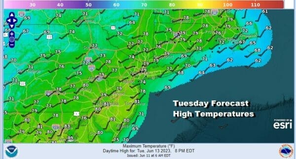
In the meantime this Tuesday we will see sunshine through varying amounts of haze. Temperatures today will be in the mid to upper 70s. No rain is forecast as the atmosphere is relatively stable however we do have another cold front to deal with on Wednesday. No issues are forecast tonight with mainly clear skies and most lows in the 50s inland and 60 to 65 in warm urban settings and along the coast.
SATELLITE

WEATHER RADAR

The Great Lakes upper low is a cold core system and it will drop southeast into Western Pennsylvania and Western NY. This creates a cold unstable atmosphere overhead Wednesday. On the surface a low drops from Michigan to Western Pennsylvania and then moves northeast into NY state.

A cold front will swing around and produce clouds and some showers and a few thunderstorms and while there is no indication from the Storm Prediction Center of severe weather, we would not be surprised given the cold atmosphere that some thunderstorms could become rather strong. Temperatures Wednesday will be in the 70s to around 80 degrees. Smoke could be an issue Wednesday as it wraps around the upper air system.

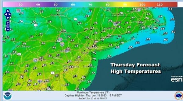
The upper air storm moves to New England and the cold front offshore and that leaves us with a nice day Thursday. Sunshine will take highs again in the 70s to around 80 with no rain in the forecast. However we do have the next upper low in the Great Lakes taking shape and moving southeastward for Friday.
Friday looks like a repeat of Wednesday as another upper air storm moves into Pennsylvania and NY state creating an unstable atmosphere and therefore, the risk for showers and thunderstorms though it is hard to say exactly who gets what and where they set up. It is conceivable some areas see very little from this system. However the instability lasts all day as this system will be slower to move. There will likely be some sun in the mix and highs will be in the mid 70s to some lower 80s Friday afternoon.

Father’s Day weekend doesn’t look too bad at all. Yes we will have an unstable atmosphere Saturday and we will need to throw in the chance for scattered showers or a thunderstorm, most of the time it should be fine with no worse than a mix of sun and clouds and highs into the 80s. Sunday should be about the same with probably fewer if any showers and perhaps more in the way of sun. Highs will be in the 80s. Throughout the next 7 days we will be impacted by areas of smoke of varying degrees and we will be addressing this issue day to day.
BE SURE TO DOWNLOAD THE FREE METEOROLOGIST JOE CIOFFI WEATHER APP &
ANGRY BEN’S FREE WEATHER APP “THE ANGRY WEATHERMAN!
MANY THANKS TO TROPICAL TIDBITS FOR THE USE OF MAPS
Please note that with regards to any severe weather, tropical storms, or hurricanes, should a storm be threatening, please consult your local National Weather Service office or your local government officials about what action you should be taking to protect life and property.
(Amazon is an affilate of Meteorologist Joe Cioffi & earns commissions on sales.)


