Sunshine Next Two Days Cold Front Arrives Friday Night Saturday,
Offshore Storm Stays Offshore

Sunshine Next Two Days Cold Front Arrives Friday Night Saturday,
Offshore Storm Stays Offshore
We are into the best part of the weather week with high pressure along the coast edging just offshore and a southwest wind developing today. We don’t see any real issues here today as we should mainly sunny skies. Temperatures which have been on the chilly side the last few days will start to move higher today and we should reach the low and middle 50s in most places this afternoon. Radars are nice and quiet and we have no precipitation worries into Friday.
SATELLITE WITH LIGHTNING STRIKES

WEATHER RADAR

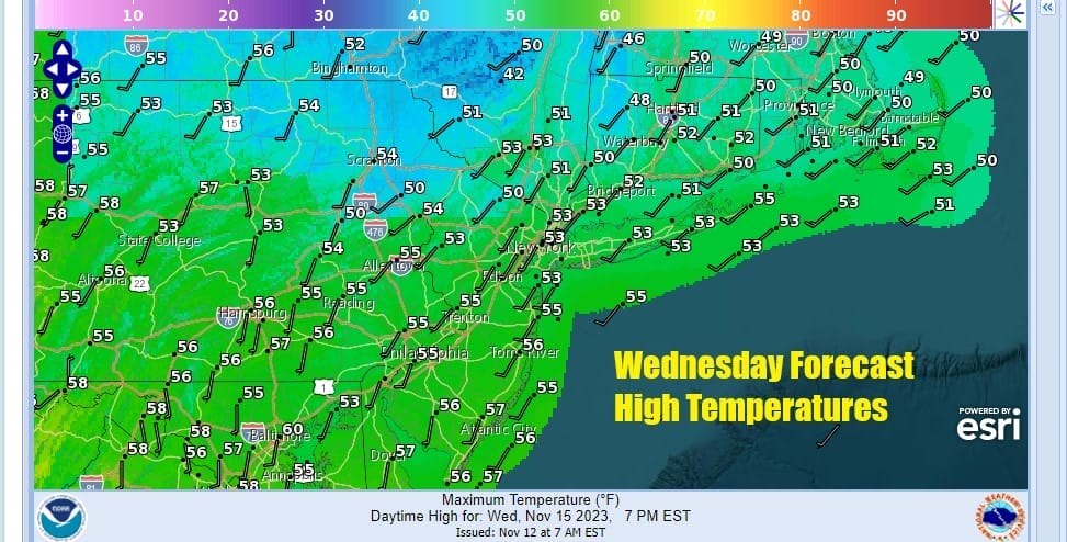
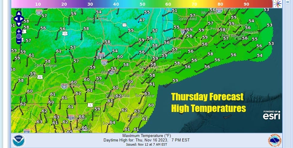
Skies will be mainly clear tonight with most lows in the 30s inland and low to mid 40s warmer urban areas. Sunshine continues Thursday but we will see temperatures nudge up a bit higher and most places will break into the 60s for highs Thursday afternoon.
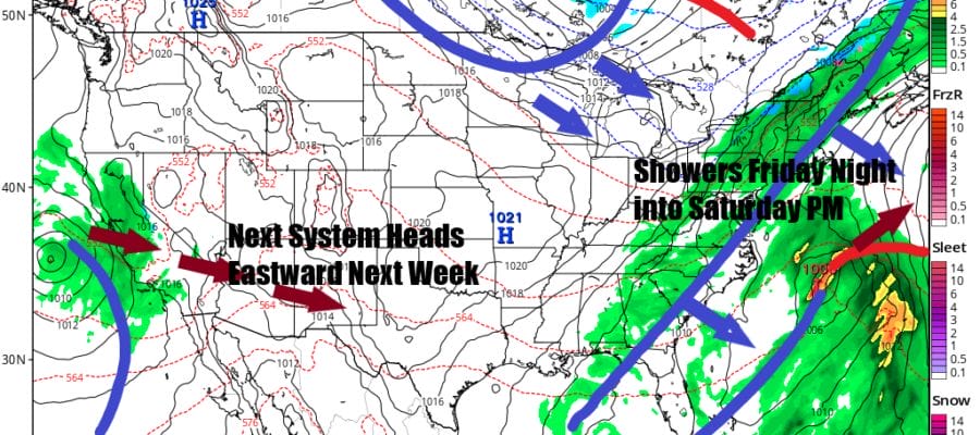
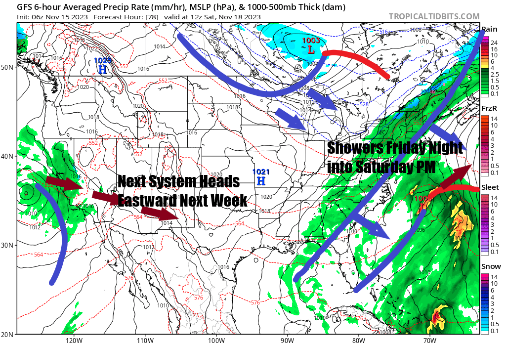
Now we move on to Friday. Low pressure that today is sitting in the Northern Gulf of Mexico will weaken and reform off the southeast coast of Florida. This low is not tropical in nature and it will slowly strengthen and move northeastward. Friday will be a day of some early sun followed by arriving clouds with most highs into the 60s.

The low will track to off the New England coast and be mainly offshore. Meanwhile a cold front is push east across the Great Lakes and Ohio Valley and that front will bring showers to much of the area Friday night into Saturday afternoon. This front is not going to produce much in the way of rain and the front should keep on moving and not stall offshore and to our south.

With this in mind showers and a shifting wind to the northwest will keep temperatures in the 50s Saturday. We have a shot of colder air coming in behind the front for Sunday which will definitely be the better of the two weekend days. We will call it clouds and sun for Sunday with highs in the upper 40s and lower 50s. There is a front and upper trough that will be moving southeast from the Great Lakes bringing a slight re-enforcement of colder air to start of Thanksgiving week.
Next week is Thanksgiving week and ahead of the big travel week we see no real issues Monday into Tuesday other that it will be on the chilly side in the Northeast and Northern Mid Atlantic. Low pressure coming into California will move quickly east and reform in the Southern Plains and then push east and northeast for late Tuesday into part of Wednesday.
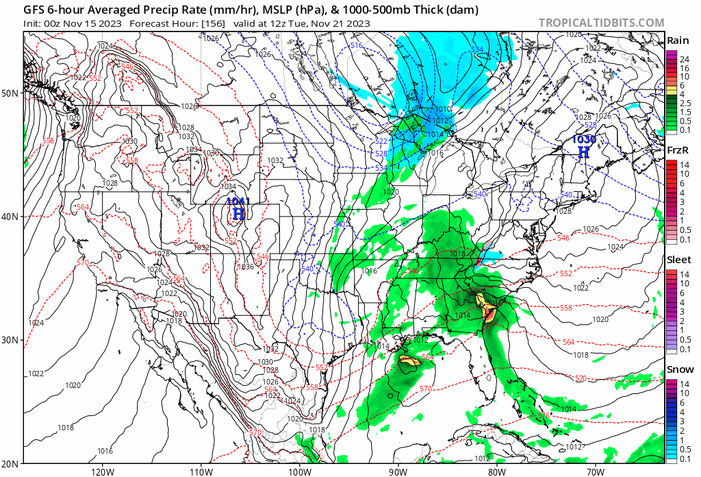
At the moment we continue to see major differences in how models are handling this ranging from a strong storm system into the Eastern Great Lakes and a soaking wind and rain storm for Tuesday and Wednesday, to a weaker colder and slightly less inconvenient solution of a weaker low and a cold rain, perhaps some snow in colder areas of upstate NY and New England. There are still too many balls in the air to figure out which is the more likely outcome but it seems that weather will be impacting a week where a lot of people will be travelling. It does appear that Thanksgiving Day itself will be a quiet dry day for much of the Eastern US with no major issues other than it will be on the chilly side.
BE SURE TO DOWNLOAD THE FREE METEOROLOGIST JOE CIOFFI WEATHER APP &
ANGRY BEN’S FREE WEATHER APP “THE ANGRY WEATHERMAN!
MANY THANKS TO TROPICAL TIDBITS FOR THE USE OF MAPS
Please note that with regards to any severe weather, tropical storms, or hurricanes, should a storm be threatening, please consult your local National Weather Service office or your local government officials about what action you should be taking to protect life and property.
(Amazon is an affilate of Meteorologist Joe Cioffi & earns commissions on sales.)


