Sunshine Less Wind Today Frost Inland Tonight
Nice Saturday Watching Gulf Low Sunday
We are still dealing with breezy conditions today as low pressure moves into Canada. The gradient has weakened somewhat but we are still seeing some gusts to 25 to 30 mph. Those winds will continue to ease as the day wears on. We are looking at partly to mostly sunny skies and it will be chilly today. Highs will probably not get out of the 50s for the second day in a row. Other than some passing clouds we will have a nice day and nothing should be popping up on the radars today.
SATELLITE

REGIONAL RADAR

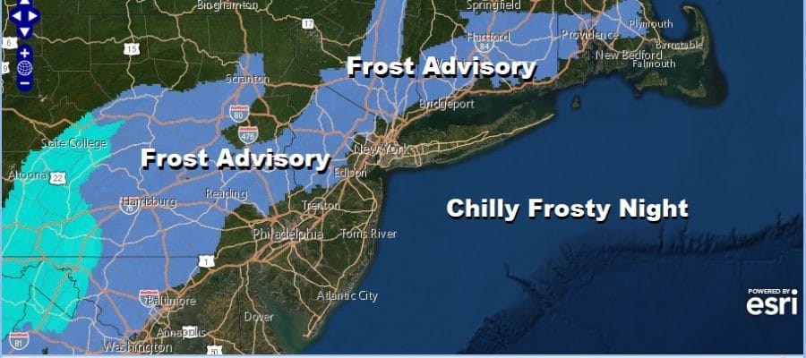
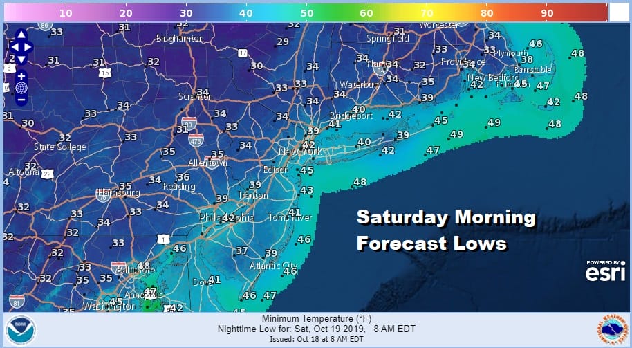
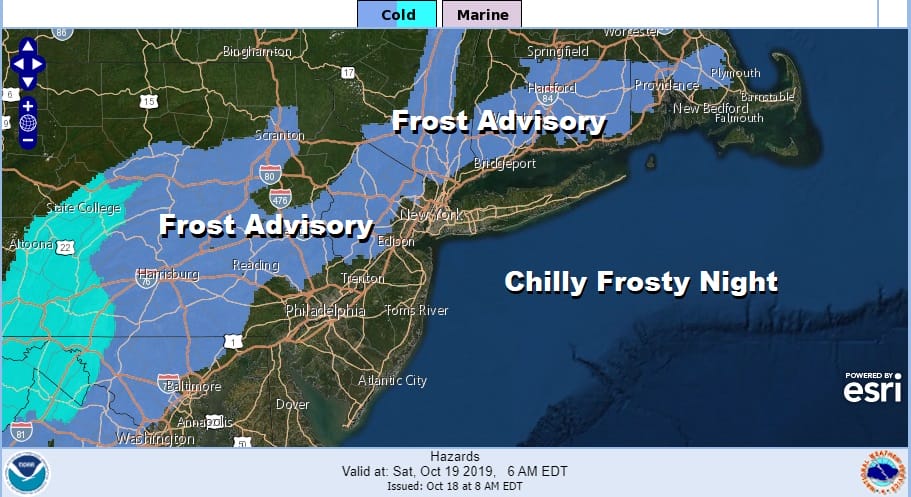
Tonight we are going to see clear skies and light to calm winds with high pressure moving overhead. This sets us up for a widespread frost inland with morning lows in the low to mid 30s. It will be closer to low 40s in the warmer urban areas.
Saturday is looking like the better of the two weekend days with lots of sunshine and highs back into the 60s. Then attention turns to the track of what is being called potential tropical cyclone 16 that could become a subtropical storm later today. An Air Force Plains is currently investigating the system to see whether it has attained some tropical characteristics. Convection has become a bit more concentrated on the morning satellite loops so we will see what they find.

Whether this becomes tropical or not as far as we are concerned really doesn’t matter too much as this system will be come an extra tropical system once it moves inland and into the Southeast Coast of the US. Heavy rains will be spreading from the Florida panhandle to North Carolina on Saturday. From there the question remains how far north does this get before it begins to slide to the east.

Right now the path as far as the forecast is concerned is for increasing clouds later Saturday night and a cloudy Sunday. Southern New Jersey gets into some rain with the northern fringe of the rain making it to about NYC and Long Island. For now we will just keep it cloudy and rain free from Northwest New Jersey to the Hudson Valley and Connecticut and wait to see if this northern model adjustment continues. Will there be enough room for this low to climb northward before it slides east?

Monday puts us in between whatever is left of the Gulf low which at this point will be somewhere offshore while a cold front to the west near the Mississippi river begins a slow push eastward. High pressure from New England tries to squeeze in between so lets call at least for clouds on Monday. Highs will be in the 60s. Tuesday look for cloudy skies with showers developing late in the day or Tuesday night. The front should keep on moving with some sunshine return along with chilly temperatures for Wednesday and Thursday.
MANY THANKS TO TROPICAL TIDBITS FOR THE USE OF MAPS
Please note that with regards to any severe weather, tropical storms, or hurricanes, should a storm be threatening, please consult your local National Weather Service office or your local government officials about what action you should be taking to protect life and property.


