Winds Slowly Drop Off Weather Conditions Slowly Improve Weekend Questions For Sunday
This major storm was quite the powerhouse. 100 mph wind gusts at Cape Cod, 60 to 70 mph winds across Long Island and Southern New England, 50 mph gusts along the New Jersey shore, and an enormous amount of rain in many areas all from this massive low that is still churning in New England this evening.
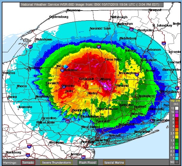
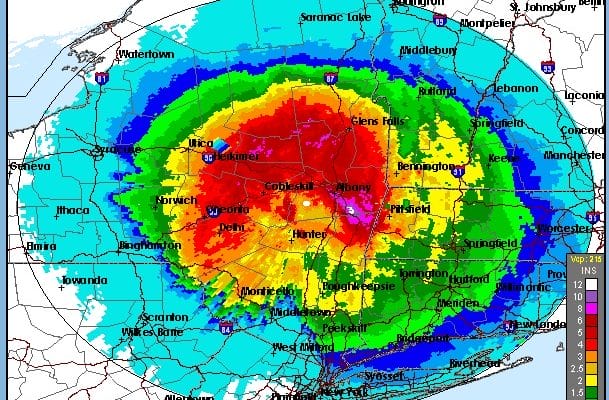
We pulled down three doppler storm total graphics from the National Weather Service. Upstate NY got creamed with a large area of 4 to 6 inches of rain. Downstate rain amounts were generally in the 1 to 2 inch range though much of that rain fell in about 6 hours time.
The Burlington Vermont radar also shows 2 to 4 inch rains from its vantage point in parts of Western Vermont and Eastern NY. It is still raining in upstate NY and parts of New England so we will see these totals likely edge higher before this is all set and done.

Our storm is still an obvious standout on the satellite picture this evening and it is only creeping eastward. Skies have at least partially cleared across Virginia east to Delaware and we should see skies partially clear tonight over Eastern Pennsylvania to Southern New England. Winds are also going to be slowly diminishing and Wind Advisories will be coming down this evening in most of our area though they may remain up in interior New England for at least part of tonight.
SATELLITE

REGIONAL RADAR

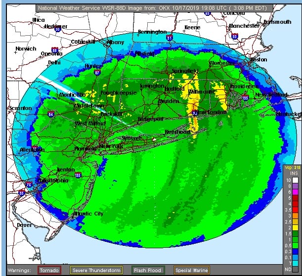
Radar is still showing bands of rain upstate NY and Western New England. Some showers are also showing up on the Upton NY local radar with some showers in Connecticut. They could clip Long Island this evening should they hold together.
LOCAL RADAR NEW YORK CITY

As skies partially clear tonight lows will bottom mostly in the 40s. Winds will keep temperatures from falling too much. Friday will still be breezy for awhile with a mix of sun and clouds and highs in the 50s to around 60. Friday night looks nice and clear with lows in the 40s. Saturday look for sunshine most of the day with high pressure overhead. Highs Saturday will be back into the 60s.

Low pressure in the Gulf of Mexico is likely to become Tropical Storm Nester tonight or on Friday and head northeast to somewhere along the Eastern Gulf Coast. From there as the system turns post tropical, rain is likely to spread through the Southeast US and could reach as far north as Virginia and the Delmarva Peninsula late Saturday night into Sunday. With high pressure to the northeast and a bit of an onshore flow we could see clouds around on Sunday with highs in the 60s but for now it appears that any post tropical low will slide east off North Carolina and keep the rain from getting here. That leaves us in a decent spot for Monday with some sunshine and clouds. HIghs will be in the 60s. Then the next cond front approaches for Tuesday with the likelihood for some showers late in the day or at night into early Wednesday.
MANY THANKS TO TROPICAL TIDBITS FOR THE USE OF MAPS
Please note that with regards to any severe weather, tropical storms, or hurricanes, should a storm be threatening, please consult your local National Weather Service office or your local government officials about what action you should be taking to protect life and property.


