Sunshine Going Into the Weekend Showers Saturday Night
Warmer Sunday & Monday

Sunshine Going Into the Weekend Showers Saturday Night
Warmer Sunday & Monday
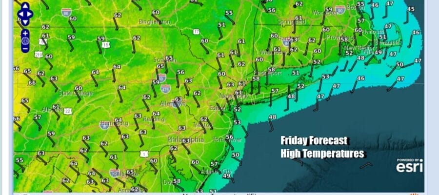
 It was a very chilly morning with widespread frosts and freezes but the good news is the core of the cold air mass moves out today. Winds will turn south southeast, and with plenty of sunshine, we should see high temperatures recover to the upper 50s and lower 60s with the coolest temperatures near south and east facing shorelines. Satellite loops and radar loops are nice and clear and we have no serious weather issues for today or tonight. Temperatures tonight except for the coldest inland spots will bottom in the mid 30s to lower 40s under clear skies.
SATELLITE WITH LIGHTNING STRIKES

WEATHER RADAR

All of the weather action right now is in the Plains and the Mississippi River Valley as severe weather and heavy rains are into their second day. Two storm systems are in play here. The first storm system heads northeast into Minnesota and Central Canada, However a second storm coming into Southern California heads to the Colorado and takes a similar track as the first storm.

The result will be more severe weather for the Plains and over the weekend in the Mississippi River Valley. This comes with elevated tornado risk and heavy rain of several inches or more in many locations. The west storm track means the Eastern US is going to be in good shape overall this weekend with one minor interruption.
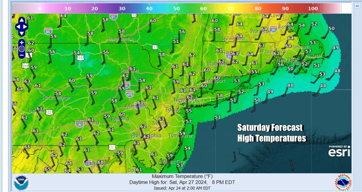 Saturday should start with some sunshine though there might be some coastal low clouds around early in the day. Then clouds will roll in as the flow off the ocean continues and we have an approaching warm front moving across the Great Lakes and Northeast. Highs will be gain in the upper 50s and lower 60s thanks to the cool flow from off the ocean.

Saturday night into Sunday morning the warm front goes by with a few showers overnight. Clouds should give way to sunshine rather quickly Sunday morning from west to east and winds will turn southwest. Temperatures will climb and Sunday afternoon highs should be in the 70s everywhere with some warm spots possibly approaching 80. Monday will be the warmest day of this current stretch with sunshine and highs in the 80s. Shore areas will be cooler with local sea breezes. Tuesday brings a cold front and the chance for late day showers and thunderstorms. Highs will be in the mid 70s to lower 80s.
BE SURE TO DOWNLOAD THE FREE METEOROLOGIST JOE CIOFFI WEATHER APP &
ANGRY BEN’S FREE WEATHER APP “THE ANGRY WEATHERMAN!
MANY THANKS TO TROPICAL TIDBITS FOR THE USE OF MAPS
Please note that with regards to any severe weather, tropical storms, or hurricanes, should a storm be threatening, please consult your local National Weather Service office or your local government officials about what action you should be taking to protect life and property.
(Amazon is an affilate of Meteorologist Joe Cioffi & earns commissions on sales.)


