
Sunny Days Clear Chilly Nights Through Monday Frosts Freezes Well North
JOE & JOE WEATHER SHOW PODCAST 9/18/2020
Autumn has arrived early in the Northeast and Middle Atlantic states and just in time for the last weekend of the summer season. It was a summer filled with humidity and heat though the heat never really got too extreme other than the odd day here and there. The pattern this month has been a fast one across Canada and cool air masses have been coming down and this one plans to stay with us through Tuesday. Skies continue to clear from west to east this evening as dry air and high pressure build across Southern Canada and New England.
SATELLITE

REGIONAL RADAR

We will start tonight with clear skies and high pressure building in sending temperatures down into the 40s in our area. Lower 50s will be confined to warmer coastal locations as well as warmer urban areas around NYC & Philadelphia.
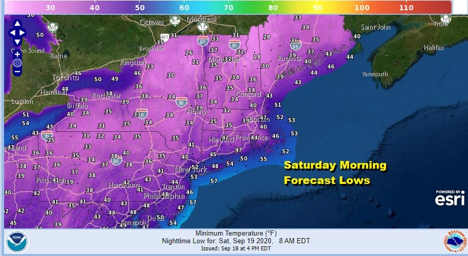
However from Northern Pennsylvania, across much of upstate NY and interior New England we will see a wide area of 30s and this has initiated the first freeze warnings and frost advisories for many of these areas. The growing season is coming to an end.
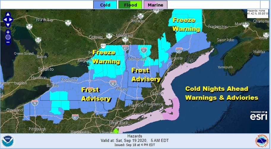
Saturday brings us a sunny but cool day with most highs just in the 60s and some areas to the north in upstate NY and New England will likely have a tough time getting above 60. Then we head down again Saturday night into Sunday morning with most lows in the 30s and 40s. It will pretty much repeat the temperatures of Saturday morning so expect another wide area of frost advisories and freeze warnings.
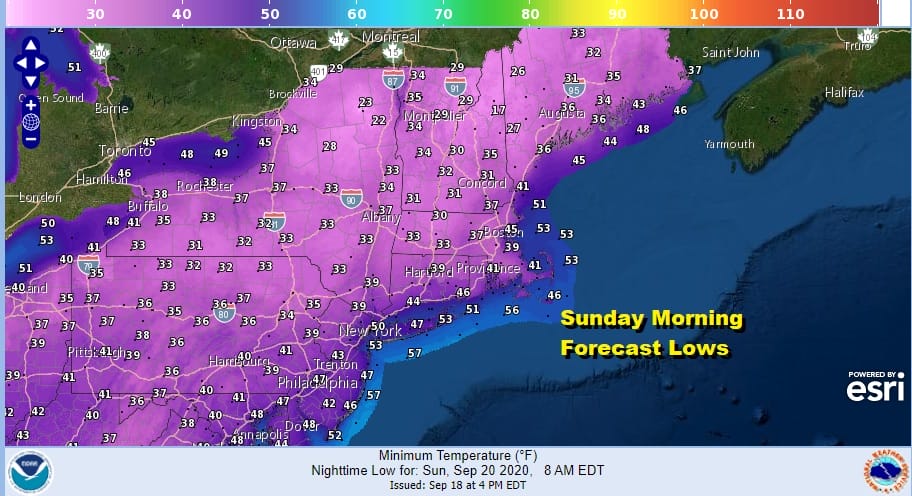
Sunday we will have lots of sunshine again but it will be quite cool with highs at best in the low 60s over a large area from Virginia to Southern New England. Areas from Northern Pennsylvania northeast into interior New England will not get out of the 50s. That brings us to probably the coldest night of this series as Sunday night into Monday morning will be a chilly one indeed.
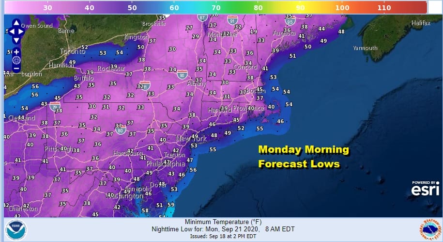
We could see 30s Sunday morning as far south as Northern New Jersey and across much of Pennsylvania except for perhaps the southeast part of the state. Even the warmer urban areas will see lows in the 40s for the first time since last May! Monday we will have a third day of lots of sunshine with highs in the 60s.

There are no changes in the outlook for next week with Hurricane Teddy passing east of Bermuda Sunday night into Monday morning and then race northward for a landfall in Nova Scotia Tuesday as either a strong hurricane or a transition to a powerful extratropical storm. To the southwest in the Gulf of Mexico Tropical Storm Beta which could become a hurricane looks to possibly hit the Texas coast in a slow moving track where we could see the storm staddle the entire Texas coast. There is lots of uncertainty here due to the very weak upper flow across the Southern US. In between we will be dry through Thursday. Sunshine and clouds Tuesday will send highs in the 60s to near 70. Winds will turn from northeast to northwest with Teddy to our northeast. Wednesday we will see some sunshine with highs in the 70s. Thursday could be the warmest day of next week with highs in the 70s to near 80. The next cold front will bring the first chance for showers next Friday.
MAJOR HURRICANE TEDDY, TROPICAL STORM WATCH ISSUED FOR BERMUDA
5PM LOCATION…23.1N 57.0W
ABOUT 795 MI…1275 KM SE OF BERMUDA
MAXIMUM SUSTAINED WINDS…125 MPH…205 KM/H
PRESENT MOVEMENT…NW OR 320 DEGREES AT 14 MPH…22 KM/H
MINIMUM CENTRAL PRESSURE…951 MB…28.08 INCHES
Today was a record setting day in the tropics as we have now exhausted the entire name list for 2020. This is only the second time on record that this has happened and it beat 2005 on getting to the Greek alphabet by a month! 3 systems were designated as tropical storms today. Even the former Paulette which is an North Atlantic ocean storm will be drifting southward over the next few days into warmer water and could come back as a tropical storm over the weekend!
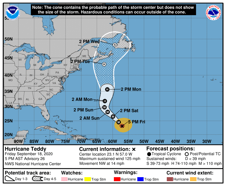
Hurricane Teddy is our major hurricane on the map tonight. Teddy will continue northwest and then turn to the north. It should be in time for the hurricane to make a pass to the east of Bermuda Sunday night into Monday morning and sparing the island a second direct hit from a hurricane in a week. From here a trough off the Northeast coast will grab Teddy and keep it moving northward for a possible landfall in Nova Scotia on Tuesday. We will be watching developments over the weekend but it appears that the risk of Nova Scotia getting hit either by a strong hurricane or a powerful extratropical storm are growing.
TROPICAL STORM WILFRED
LOCATION…12.5N 34.4W
ABOUT 735 MI…1185 KM WSW OF THE CABO VERDE ISLANDS
MAXIMUM SUSTAINED WINDS…40 MPH…65 KM/H
PRESENT MOVEMENT…WNW OR 285 DEGREES AT 18 MPH…30 KM/H
MINIMUM CENTRAL PRESSURE…1008 MB…29.77 INCHES

Tropical Storm Wilfred is in the Tropical Atlantic and it seems that Wilfred will eventually run into a hostile environment later Sunday into Monday thanks to strong upper air winds generated by the trough leftover from Teddy. Top winds are 40 mph and it might get a little stronger tonight into Saturday before weakening.
SUBTROPICAL STORM ALPHA
5PM LOCATION…40.4N 8.4W
ABOUT 120 MI…195 KM NNE OF LISBON PORTUGAL
MAXIMUM SUSTAINED WINDS…45 MPH…75 KM/H
PRESENT MOVEMENT…NE OR 40 DEGREES AT 17 MPH…28 KM/H
MINIMUM CENTRAL PRESSURE…998 MB…29.47 INCHES
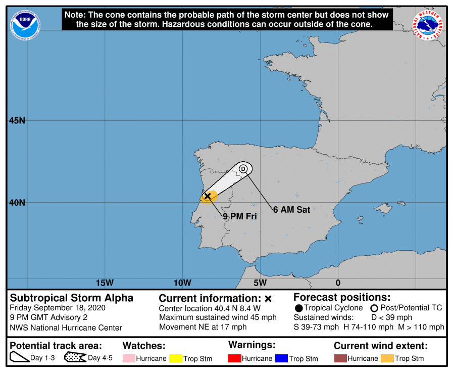
Subtropical Storm Alpha is our most unusual storm of the season. It formed out of a large non tropical storm off the coast of Portugal and made landfall today. It is going to continue inland and weaken. Storms forming in the Eastern Atlantic and heading into Europe occur from time to time and since this 2020, does this really surprise anyone?
TROPICAL STORM BETA FORMS IN THE GULF OF MEXICO

Tropical Storm Beta has formed in the Southwest Gulf of Mexico and this storm will be watched very closely due to the proximity to the Texas coast and because the steering flow in the upper atmosphere is very weak. Conditions are favorable for strengthening and Beta could become another slow moving hurricane in the Gulf of Mexico.
5PM LOCATION…24.3N 93.1W
ABOUT 335 MI…545 KM ENE OF TAMPICO MEXICO
ABOUT 280 MI…450 KM ESE OF MOUTH OF THE RIO GRANDE
MAXIMUM SUSTAINED WINDS…40 MPH…65 KM/H
PRESENT MOVEMENT…NNE OR 25 DEGREES AT 9 MPH…15 KM/H
MINIMUM CENTRAL PRESSURE…1004 MB…29.65 INCHES
For now there are no watches posted for the Western Gulf coast however I would expect some watches to go up either later tonight or on Saturday for a portion of the Western Gulf Coast. This storm could be around for awhile as long as the upper flow across the Southern US remains weak. We will be watching this one closely and reporting on it over the weekend of course tonight on the Joe & Joe Weather show on my Youtube Channel at 7pm eastern time live and also available on replay later tonight.
BE SURE TO DOWNLOAD THE FREE METEOROLOGIST JOE CIOFFI WEATHER APP &
ANGRY BEN’S FREE WEATHER APP “THE ANGRY WEATHERMAN!
MANY THANKS TO TROPICAL TIDBITS FOR THE USE OF MAPS
Please note that with regards to any severe weather, tropical storms, or hurricanes, should a storm be threatening, please consult your local National Weather Service office or your local government officials about what action you should be taking to protect life and property.


