DOWNLOAD MY NEW FREE JOESTRADAMUS WEATHER APP FOR ALL DEVICES
THE APP IS ABSOLUTELY FREE TO ALL BUT CONSIDERING SUBSCRIBING TO PATREON FOR A WEATHER EXPERIENCE FREE OF ADS, EXCLUSIVE VIDEOS FOR MEMBERS ONLY AND MUCH MORE…STARTS AT $2 A MONTH..MESSAGE ME AT ANY TIME
Sun Trying To Break Through Raw Cloudy Wednesday Showers Late Week Rain Weekend
It has been a struggle today to get the low clouds out of the way. They are particularly stubborn from NYC to Southern New England and Long Island where temperatures are holding in the 40s in many areas. Meanwhile the sun is trying to break through the clouds in parts of Northern New Jersey this afternoon while South Jersey and Eastern Pennsylvania are having better luck. Other than some spotty drizzle where the low clouds are hanging tough the radars remains quiet and at least from that respect no rain is around for today and for most of tonight. Clouds however will be back tonight as an onshore flow begins again and there could be some spotty light rain or drizzle around by morning with temperatures settling in the 40s.
SATELLITE

REGIONAL RADAR

Wednesday is another day in cloudy skies with spotty light rain or drizzle. Temperatures could make it into the low and mid 50s for highs. We are going to wait for another warm front to the south to pass by Wednesday night into Thursday morning when there could be a few showers as the front goes by.

Now comes the issue for Thursday. The warm front will get stuck again and the latest weather models are pinching that warm front a little further southwest from previous runs. East of that front its 40s and 50s with low clouds and fog…to the west 70s to near 80 with some sunshine. It makes for another tough forecast with a potential spread of 30 degrees from low to high over a handfull of miles. I threw in a chance for a shower or thunderstorm in the warm air late Thursday. Then it is back to onshore flow Thursday night into Friday as the front buckles back southward. With that the chance for showers or a thunderstorm late Friday into Friday night as the warm front goes by to the north and a cold front comes in from the west.
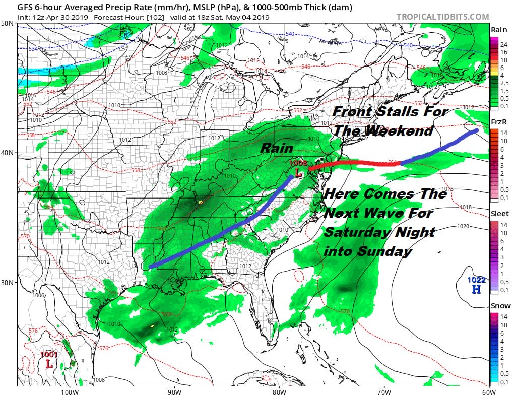
That cold front is going to (you guessed it) stall to our south and 2 waves of low pressure moving along it will bring clouds on Saturday later in the day. Unfortunately that low is not going to intensify and get all of this out of here. Another wave is likely to develop and approach bringing more rain Sunday.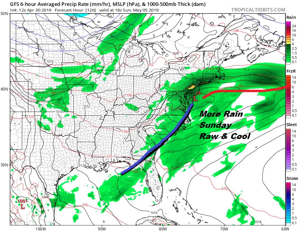
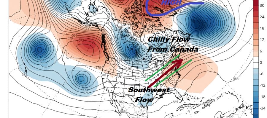
We may have to wait until Monday or Tuesday of next week to get a “clean” day of some sunshine with very little in the way of showers and no onshore flow to spoil things. Unfortunately a blocking pattern in the spring doesn’t do you any good if you are not in the right place. Blocking remains a problem across the North Atlantic.
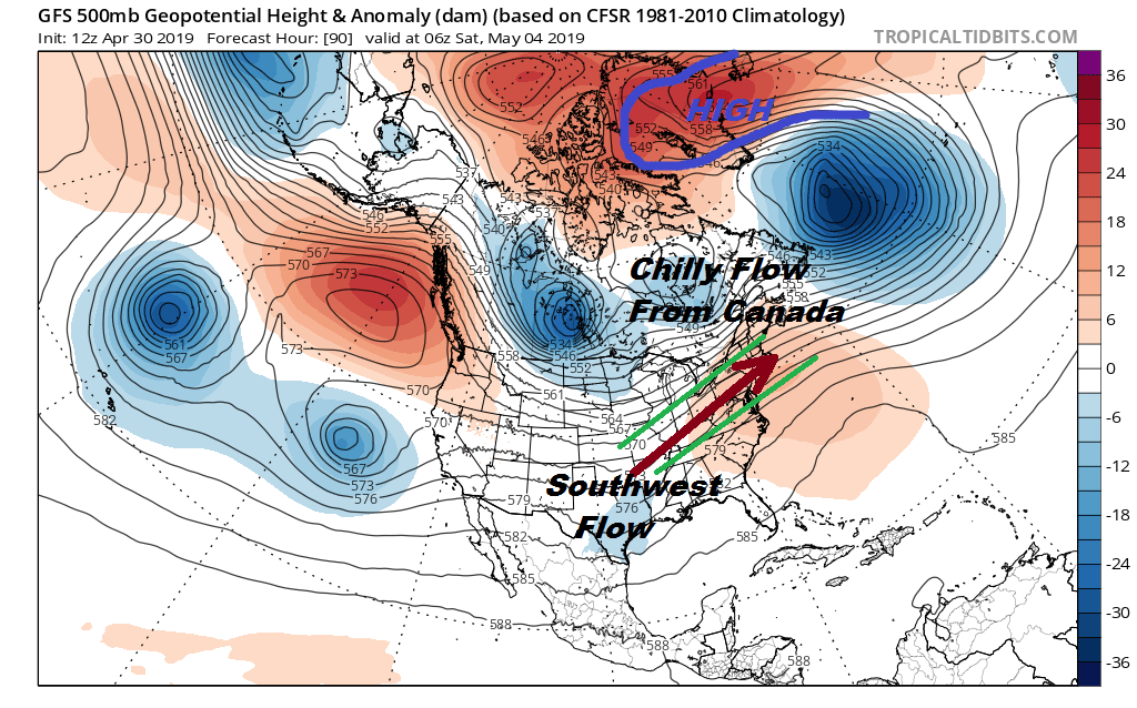
The blocking high in the north suppresses the jet stream south into Canada and along the US border. Cool Canadian air bleeds southward while a southwest flow of warm air streams toward the northeast and inside the green lines I’ve drawn. We have been lying inside this battle zone and will remain locked inside that zone until there is some meaningful change in the upper air pattern. There are no signs of this happening anytime soon.
MANY THANKS TO TROPICAL TIDBITS FOR THE USE OF MAPS
Please note that with regards to any tropical storms or hurricanes, should a storm be threatening, please consult your local National Weather Service office or your local government officials about what action you should be taking to protect life and property.


