
Strong Front Brings Rain & Severe Weather Risk & Wind
Drying Out Thursday & Friday
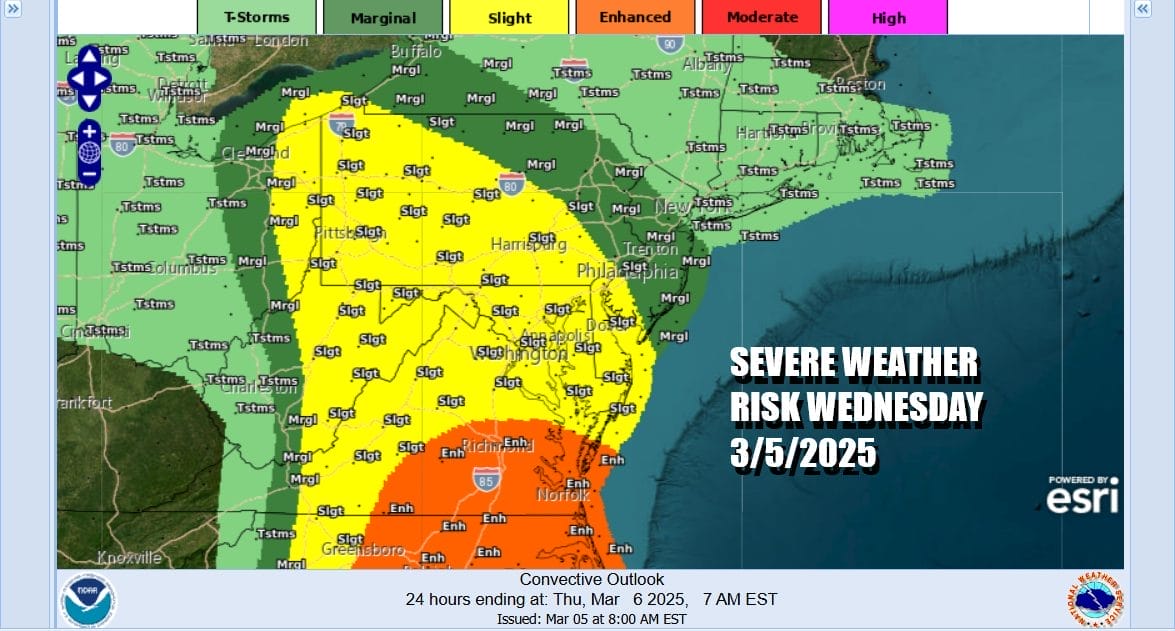
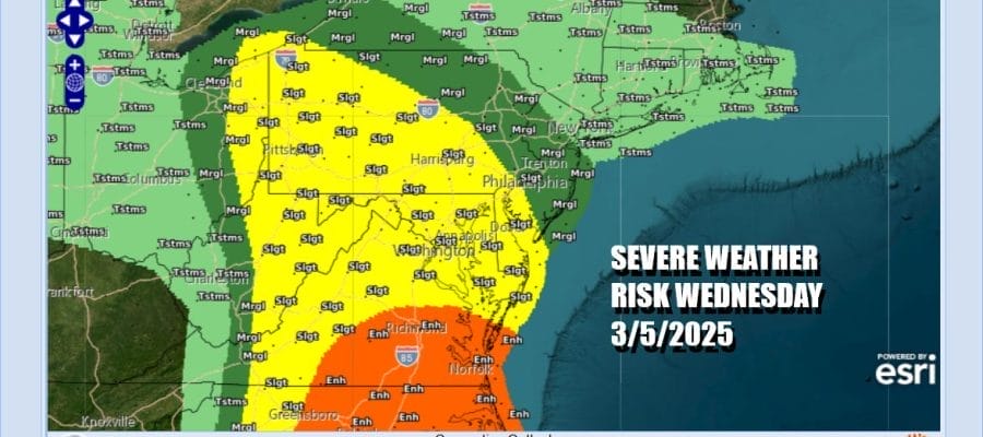
It is a busy weather day across the Eastern US as a powerful storm moves through the Great Lakes and a strong cold front that brought severe weather to the Gulf States yesterday now heads for the east coast. Clouds have rolled in and now we set up for showers, thunderstorms and the potential for severe weather from New Jersey and Pennsylvania southward into the Carolinas. The Storm Prediction Center is indicating marginal risk in most of New Jersey and Northeastern Pennsylvania. Slight to enhanced risk exists from Southern New Jersey and the rest of Pennsylvania southward into Maryland, Delaware, Virginia and the Carolinas.
SATELLITE WITH LIGHTNING STRIKES

WEATHER RADAR

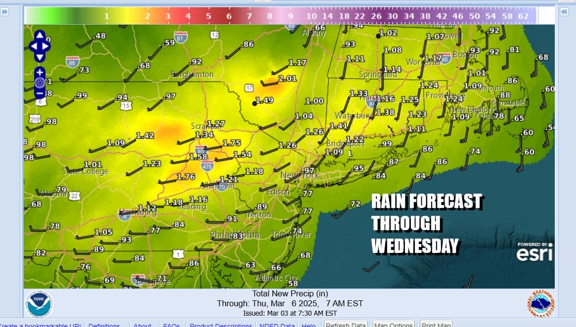
Radars are loaded up with areas of heavy rain and thunderstorms and they will be moving through this afternoon and evening. Gusty thunderstorms with heavy downpours are possible. Gusty southerly winds to 30 mph or more are possible. Temperatures today will be rising through the mid 50s to perhaps lower 60s in some places. Rainfall totals will be in the 3/4 inch to 1.25 inch range with some locally higher amounts possible where convection is a bigger player.
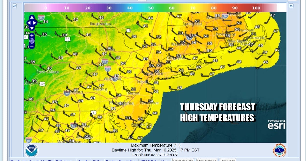
The cold front will move offshore this evening with leftover clouds overnight. Thursday will be a better day with clouds along with some sunny periods. Gusty northwest winds will develop. Temperatures however will still be on the mild side with highs in the 50s. An upper trough will play through late in the day and colder air will start moving in Thursday night.
The air behind this cold front is not especially cold so we will continue to be on the mild side of average Friday. We should see a fair amount of sunshine with highs reaching into the 50s in most places. Some clouds will move in during the afternoon as a weak weather system plays through Friday night into Saturday morning. With this system there could be some scattered rain or even some snow showers in colder inland areas. Saturday and Sunday should be dry chilly days with clouds and sun both days. Low pressure will be passing to the south as well as to the north so we should be in a dry sweet spot in between. Temperatures both Saturday and Sunday will be in the 40s.
BE SURE TO DOWNLOAD THE FREE METEOROLOGIST JOE CIOFFI WEATHER APP &
ANGRY BEN’S FREE WEATHER APP “THE ANGRY WEATHERMAN!
MANY THANKS TO TROPICAL TIDBITS FOR THE USE OF MAPS
Please note that with regards to any severe weather, tropical storms, or hurricanes, should a storm be threatening, please consult your local National Weather Service office or your local government officials about what action you should be taking to protect life and property.


