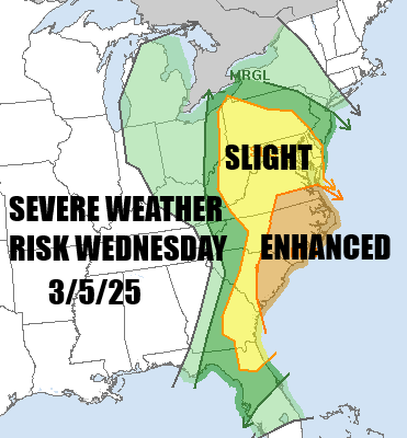

Severe Weather Risk Wednesday As Powerful Storm Heads to the Great Lakes

We are watching a developing major storm in the Central Plains that will be heading to the Great Lakes tonight and into Southeastern Canada Wednesday. Ahead of this today we are seeing the cold air pulling out and we will see temperatures recover this afternoon, reaching the upper 40s and lower 50s in most places. There will be some patchy clouds around today as satellite loops show them coming in from the west but we will also have some sunshine in the mix. South and east facing shorelines will likely see temperatures holding into the 40s today with the wind coming in off the cold ocean.
SATELLITE WITH LIGHTNING STRIKES

WEATHER RADAR

Across the Gulf States today it will be all about severe weather as a cold front pushes eastward. The front from the strong storm center will extend north south pushing a squall line of severe storms eastward. By Wednesday the weather front will be approaching the East Coast and we will see downpours and thunderstorms break out during the afternoon and evening.

Clouds will be rolling in tonight and there might be some patchy light showers around Wednesday morning but they will tend to be scattered in nature. Then look for southerly winds to increase as the day wears on, gusting to 30 to 35 mph during the afternoon and evening. There is severe weather risk for Wednesday but we expect that thunderstorms will be in the mix but a strongest thunderstorms likely stay south.
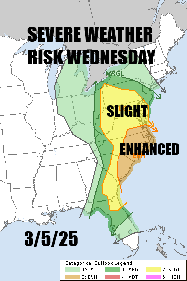
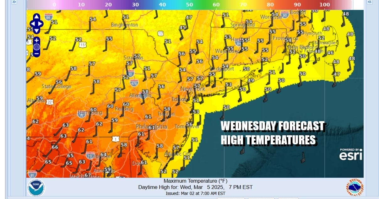
Downpours and thunderstorms Wednesday could produce anywhere from 3/4 inch to 1.25 inches of rain with some locally higher amounts possible where there is convection. Temperatures Wednesday will be in the 50s to around 60 degrees in most places with the front forecast to pass through sometime late Wednesday evening. The heaviest rain will fall somewhere between noon and midnight from west to east.
Weather conditions will only improve slowly Thursday with lots of leftover clouds especailly early in the day. Some sun will break through from time to time and it will be on the mild side with most highs in the 50s to near 60. Colder air and gusty winds will will develop Thursday night and Friday when we see sunshine returning along with highs mostly in the 40s. Right now the weekend appears to be dry as a weak storm system passes well to our south.
BE SURE TO DOWNLOAD THE FREE METEOROLOGIST JOE CIOFFI WEATHER APP &
ANGRY BEN’S FREE WEATHER APP “THE ANGRY WEATHERMAN!
MANY THANKS TO TROPICAL TIDBITS FOR THE USE OF MAPS
Please note that with regards to any severe weather, tropical storms, or hurricanes, should a storm be threatening, please consult your local National Weather Service office or your local government officials about what action you should be taking to protect life and property.


