
STORMY EUROPEAN MODEL RUN OVERNIGHT!
Stormy European model continues on the overnight model runs. Overnight models remain in a sea of inconsistency with the European model being the only one that seems to be holding some sense of continuity from run to run. Even here though there has been some run to run changes depending on how the models handle the very busy subtropical jet stream and the complex upper air pattern that is evolving across the Northern Hemisphere.
Stormy European Model System 1
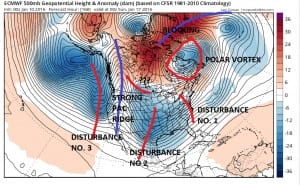
The European model is struggling with what all the models are struggling with and that is which disturbance in the the southern subtropical jet stream is the “one” or even if there is “the one”. This would be hard enough but the European model is also looking at the northern jet stream and how the polar vortex relates to all this.
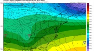


There are 2 systems this model sees. The first one is for late Friday night into Saturday. This system is the weaker of the two. The model holds in cold air across areas from Central NJ northward but it is a bit tenuous. That is the literal look of course and the details of the short term atmosphere is something you dont deal with until you actually get inside 72 hours or so. The model then has a second stronger shortwave in the southern subtropical jet stream that it turns into a major storm.
Stormy European Model System 2
The upper map illustrates the problem in forecasting all this. You have so much going on and each run handles each of these puzzle pieces differently. Each disturbance has a direct impact on the one behind it. The polar vortex is in the blocking position and there is a second disturbance in the northern jet stream that is about to swing around. The model seems to suggest that disturbance number 2 is the powerhouse (at least on this run). In the end how all these interact with each other will determine what happens. Certainly the pattern screams major storm somewhere for somebody but with all the systems running around, it is a fools game to even remotely suggest that someone has it all figured out. Here is the Stormy European model snow view over the northeast during the next 10 days.

The GFS model has its own ideas but the model volatility there has been ridiculous and out of control from tun to run. It has major storm one minute to absolutely nothing the next. Not that these possibilities aren’t real, they are. However the model has not settled on any one solution or path so I’m waiting for 3 or 4 runs in a row to get this all figured out or even remotely figured out.
First things first is the shot of cold air tonight and the clipper system with the arctic front on Tuesday night. I still think this has the chance to produce a coating to an inch or 2 in some places. I will get to this later today.
LATEST NEW EUROPEAN MODEL WEATHER VIDEO
NATIONAL WEATHER SERVICE SNOW FORECASTS
LATEST JOESTRADAMUS ON THE LONG RANGE
Weather App

Winter is here! Don’t be without Meteorologist Joe Cioffi’s weather app. It is a complete weather app to suit your forecast needs. All the weather information you need is right on your phone. Android or I-phone, use it to keep track of all the latest weather information and forecasts. This weather app is also free of advertising so you don’t have to worry about security issues with your device. An accurate forecast and no worries that your device is being compromised.
Use it in conjunction with my website and my facebook and twitterand you have complete weather coverage of all the latest weather and the long range outlook. The website has been redone and upgraded. Its easy to use and everything is archived so you can see how well Joe does or doesn’t do when it comes to forecasts and outlooks.
Just click on the google play button or the apple store button on the sidebar for my app which is onMy Weather Concierge. Download the app for free. Subscribe to my forecasts on an ad free environment for just 99 cents a month.
Get my forecasts in the palm of your hand for less than the cost of a cup of Joe!
![]()