Stair Step Chill Down This Week Snow Or Snow Ice Rain Threat Friday Night into Saturday
A second day of record highs with gusty winds and sunshine made for a very warm weekend indeed through much of the Northern Mid Atlantic states to Southern New England. Winds are easing, skies have cleared out for the most part and we will begin a bit of a stair step decline. The weather pattern is changing this week and it will take about 10 days to complete. There will also be some turbulence along the way.
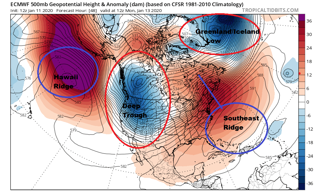
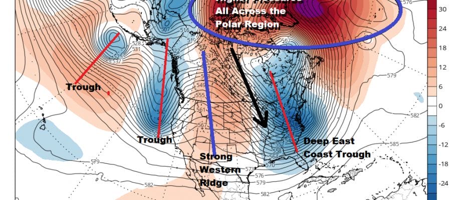
The upper air pattern above is what the jet stream looks like Monday morning. Over the course of 10 days we are going to see a radical flip in all the players. Everything will be in the opposite position from where it is now. More importantly the long range climate models suggest we are going to stay and a cold winter pattern for the last 10 days of January and in the month of February. That does not mean there can’t be brief interruptions or that it is non stop snow and cold. Forecast issues will remain but the pattern will simply be more favorable for winter weather if everything times out correctly and the highs and lows are in the right places at the right times.

In the process there is going to be some atmospheric volatility. This week it will be about stepping down one by one. The first minor step down is tonight and the Monday through Wednesday. Winds turning to the north and northeast will send the temperatures to the 30s by morning under mainly clear skies as the satellite picture shows over much of the area.
SATELLITE

Regional and local radars are done for tonight through Monday night with no issues to worry about even though today’s cold front is stalling out to the south. It is on the weak side.
REGIONAL RADAR

Monday should be no worse than partly sunny and it will be colder but still above average with highs in the 40s. Then on Tuesday and Wednesday with an onshore wind and low pressure moving east from the Great Lakes, and the old stalled front, we will likely see some clouds and maybe a few scattered showers Tuesday night into Wednesday morning. Later Wednesday and Wednesday night low pressure strengthens offshore which brings the next step down to much colder air for Thursday and Friday.
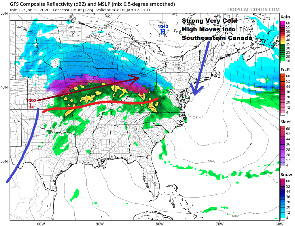
High pressure from Canada builds into Quebec which will be one of the two important keys here regarding this particular system Low pressure is heading out of Southwestern Kansas and running east northeast to near Saint Louis and then from there to Northern Ohio. This system needs to come out fast while the high in Quebec is holding on and keeping cold air wedged southward into Maryland, Delaware and Pennsylvania. Other models are a bit slower with the system ejecting from the west however they are catching up to the faster GFS idea here. We will have to see how models deal with all the timing issues and we have a solid 3 days or more before they will settle on how this plays out. This storm is significant regardless of the outcome because behind it comes the next step down to even colder air behind it.
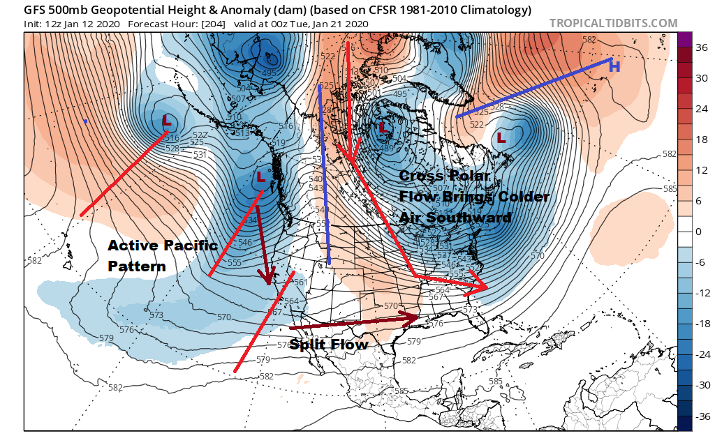
The week of January 20th will be featuring a trough in the east with “cross polar flow” which means cold air crosses the arctic regions and drives southward on those north north west upper air winds. The west has a split flow with systems coming in and that could mean more action in the long range.
BE SURE TO DOWNLOAD THE FREE METEOROLOGIST JOE CIOFFI WEATHER APP &
ANGRY BEN’S FREE WEATHER APP “THE ANGRY WEATHERMAN!
MANY THANKS TO TROPICAL TIDBITS FOR THE USE OF MAPS
Please note that with regards to any severe weather, tropical storms, or hurricanes, should a storm be threatening, please consult your local National Weather Service office or your local government officials about what action you should be taking to protect life and property.


