
Stepping Down To Colder Late Week Snow Ice Rain Likely Saturday
Anytime you get a change in temperatures 20 or more degrees colder from the day before you are going to feel it. Even though temperatures are still about 10 degrees above average there is a chill in the air today with temperatures in the 40s. I would have hoped for some breaks of sunshine today but that isn’t happening thanks to the stalled frontal boundary to our south and a light onshore flow keeping us socked in with clouds.
SATELLITE

REGIONAL RADAR

As overcast as it is the front is stalled out across southern Virginia and offshore and while you can see showers near that boundary they are sliding to the east northeast and I don’t expect to see anything from these. So it will be clouds going forward for tonight and Tuesday. Some showers might sneak in late Tuesday into Tuesday evening as a weak wave goes by to the south and low pressure passes by to our north. This shouldn’t amount to much. Temperatures Tuesday will be in the 40s.
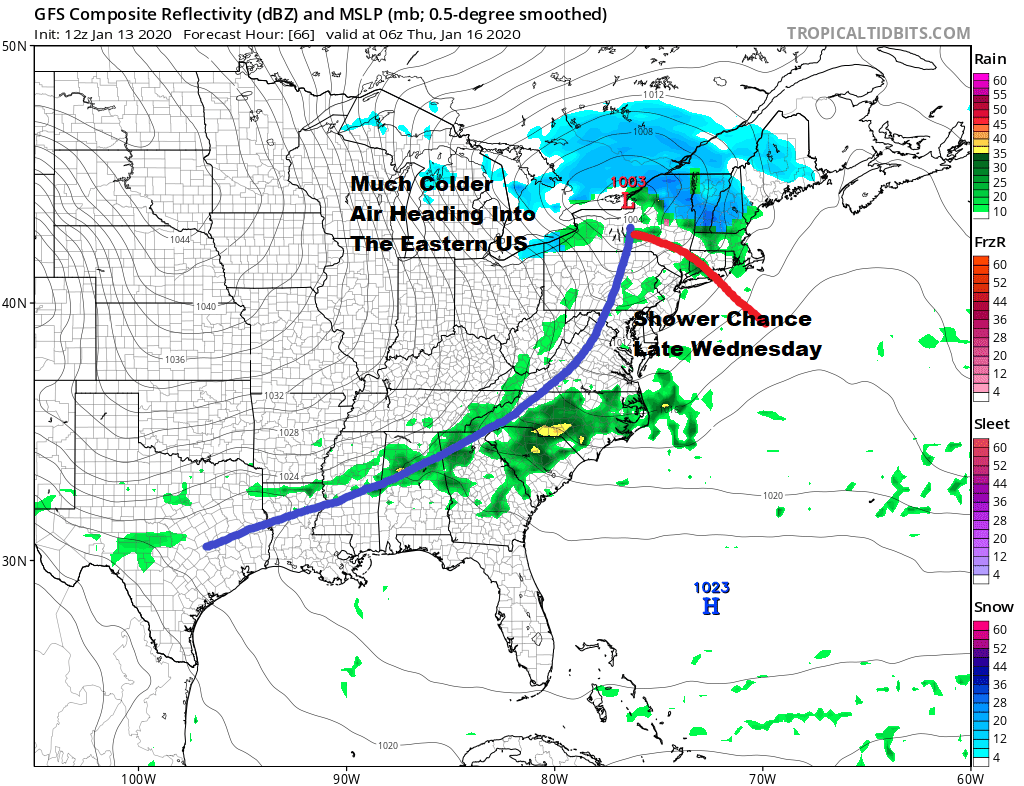
A more important cold front arrives late Wednesday into Wednesday night and there could be a few showers with this front as it goes by. We may visit the 50s on Wednesday but then colder air follows as strong high pressure drops out of Canada and begins moving eastward to the Great Lakes. Low pressure strengthens to our northeast on Thursday.
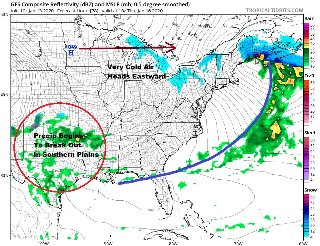
From here we will be sitting with cold air going into Saturday. The high moves into Quebec and will wedge down to Virginia. Cold air will attempt to dam in east of the Appalachians and snow will start to break out ahead of a low moving east across the Ohio Valley.
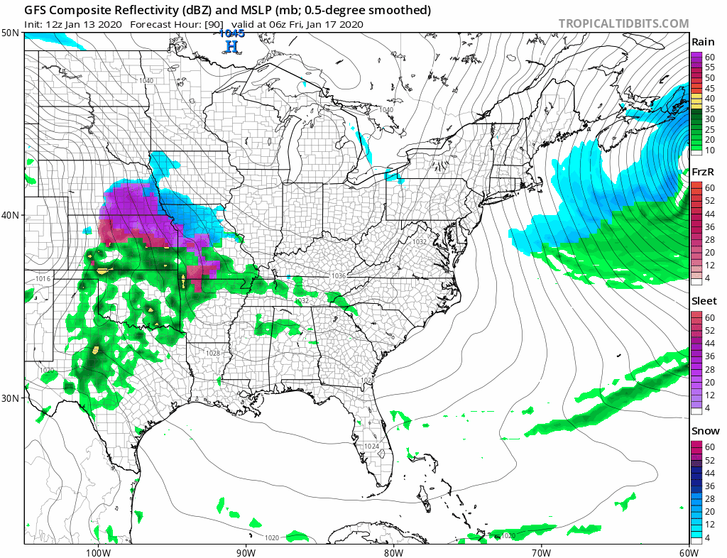
Today’s model runs are pointing to a very stubborn high to the north as the low moves east. It will likely force some sort of redevelopment of the low east of New Jersey and south of Long Island. Interestingly the models are all suggesting that cold air will be more important as they are showing snow developing as far south as Virginia. This has the makings for a 6 hour or so period of moderate (to possibly heavy) snow before warm air makes it and changes it over to sleet and rain. Obviously the change over will take place sooner from Southern New Jersey southward but it will take longer from NYC northward to the Lower Hudson Valley to Southern New England. North of Route 84 could lie in an area of jackpot snowfall here if the cold air becomes more important. This will likely produce 3/4 inch to an inch and a quarter of liquid for most of the area so the longer you avoid a change to rain, the more you will get. The threat time is for Saturday. Timing issues remain of course as well as the extent of cold air. None of this gets even close to a resolution until Wednesday or Thursday at the earliest.
BE SURE TO DOWNLOAD THE FREE METEOROLOGIST JOE CIOFFI WEATHER APP &
ANGRY BEN’S FREE WEATHER APP “THE ANGRY WEATHERMAN!
MANY THANKS TO TROPICAL TIDBITS FOR THE USE OF MAPS
Please note that with regards to any severe weather, tropical storms, or hurricanes, should a storm be threatening, please consult your local National Weather Service office or your local government officials about what action you should be taking to protect life and property.


