Spring Rains Ahead

Spring Rains Ahead
Aside from the volatility swings that occur this time of year, we also tend to lock into long periods where there is a threat for rain every couple of days. It looks like we have that combination setting up beginning with this weekend when we deal with a back door cold front on Saturday and low pressure coming in from the Ohio Valley and Great Lakes for Sunday. Beyond that there are several systems that will be moving across the US of varying strengths to bring chances for rain from time to time all of next week.
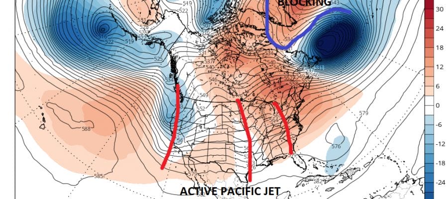
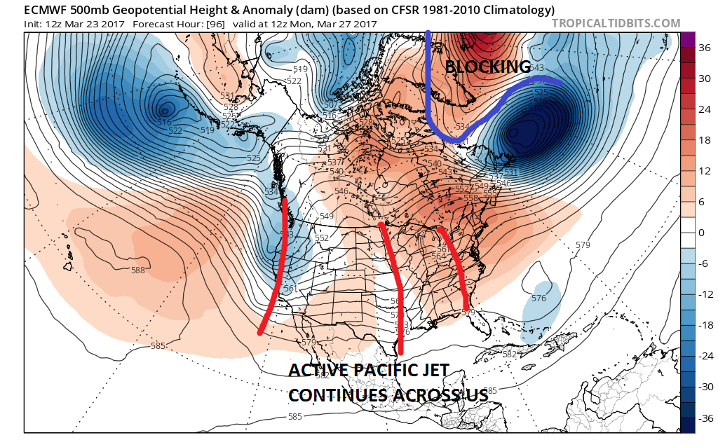 When we look at the European jet stream pattern for the beginning of next week, we see a blocking pattern in the Atlantic combining with an active Pacific jet stream moving across the United States. The result is weather systems moving across the country and taking tracks near or just to our north or just ot our south. The blocking is there without any kind of polar flow from Canada so except for the coldest areas of New England, snow is not an issue at all. For us it looks like threats for rain from time to time beginning Saturday night and lasting through all of next week. It does not rain straight through obviously as there will be short breaks in between. As far as temperatures are concerned they will depend on whether an onshore flow gets established which it will from time to time. When it is in play temperatures will be colder thanks to the marine influenece. When it isn’t it should trend back toward average. No major storms or noreasters are on the horizon.
We are seeing a rather unusual March as far as temperatures are concerned. So far the month is running 4 degrees below the average monthly temperature for this past February in New York City. If this continues it will only be the 5th time in the last 158 years where March will be colder than February. If it finishes below average it will be the first below average month temperature wise in almost 2 years! The streak for NYC stands at 20 months of consecutive above average temperatures.
MANY THANKS TO TROPICAL TIDBITS FOR THE WONDERFUL USE OF THE MAPS

GET JOE A CIGAR IF YOU LIKE!
SNOW REMOVAL COMPANIES FOR YOUR WINTER NEEDS
LONG ISLAND ROCKLAND COUNTY Connecticut

![]()

ROCKLAND COUNTY TRI STATE SNOW REMOVAL JOHNSTOWN PA


FiOS1 News Weather Forecast For Long Island
FiOS1 News Weather Forecast For New Jersey
FiOS1 News Weather Forecast For Hudson Valley
NATIONAL WEATHER SERVICE SNOW FORECASTS
LATEST JOESTRADAMUS ON THE LONG RANGE
Weather App

Don’t be without Meteorologist Joe Cioffi’s weather app. It is really a meteorologist app because you get my forecasts and my analysis and not some automated computer generated forecast based on the GFS model. This is why your app forecast changes every 6 hours. It is model driven with no human input at all. It gives you an icon, a temperature and no insight whatsoever.
It is a complete weather app to suit your forecast needs. All the weather information you need is right on your phone. Android or I-phone, use it to keep track of all the latest weather information and forecasts. This weather app is also free of advertising so you don’t have to worry about security issues with your device. An accurate forecast and no worries that your device is being compromised.
Use it in conjunction with my website and my facebook and twitter and you have complete weather coverage of all the latest weather and the long range outlook. The website has been redone and upgraded. Its easy to use and everything is archived so you can see how well Joe does or doesn’t do when it comes to forecasts and outlooks.
Just click on the google play button or the apple store button on the sidebar for my app which is on My Weather Concierge. Download the app for free. Subscribe to my forecasts on an ad free environment for just 99 cents a month.
Get my forecasts in the palm of your hand for less than the cost of a cup of Joe!
![]()
