Spring Issues Backdoors & Blocking

Spring Issues Backdoors & Blocking
Spring as we have been noting for the last number of days is not exactly the most stable of seasons. Volatility is always present it is reflected in shots of cold air interrupted by longer and longer warm ups (usually), bouts of severe weather (usually not here) and blocking which can make it gray damp and dismal for days at a time. Such is the case now with the weather pattern moving forward. We are dealing with a shot of very cold air tonight into Thursday before the warm up starts on Friday. The first issue we will be dealing with is a warm front Friday with a few showers ahead of it. If the precipitation comes in fast enough there might be an ice pellet or two in the mix for areas well inland but this is light precipitation and won’t last long at all as the bulk of it goes by to our north. Once the warm front goes by it sets up the second issue for Saturday in the form of a backdoor cold front.
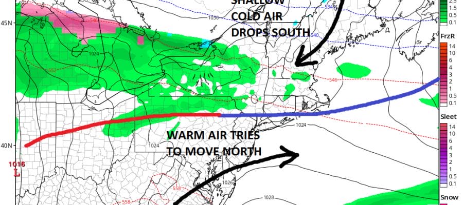
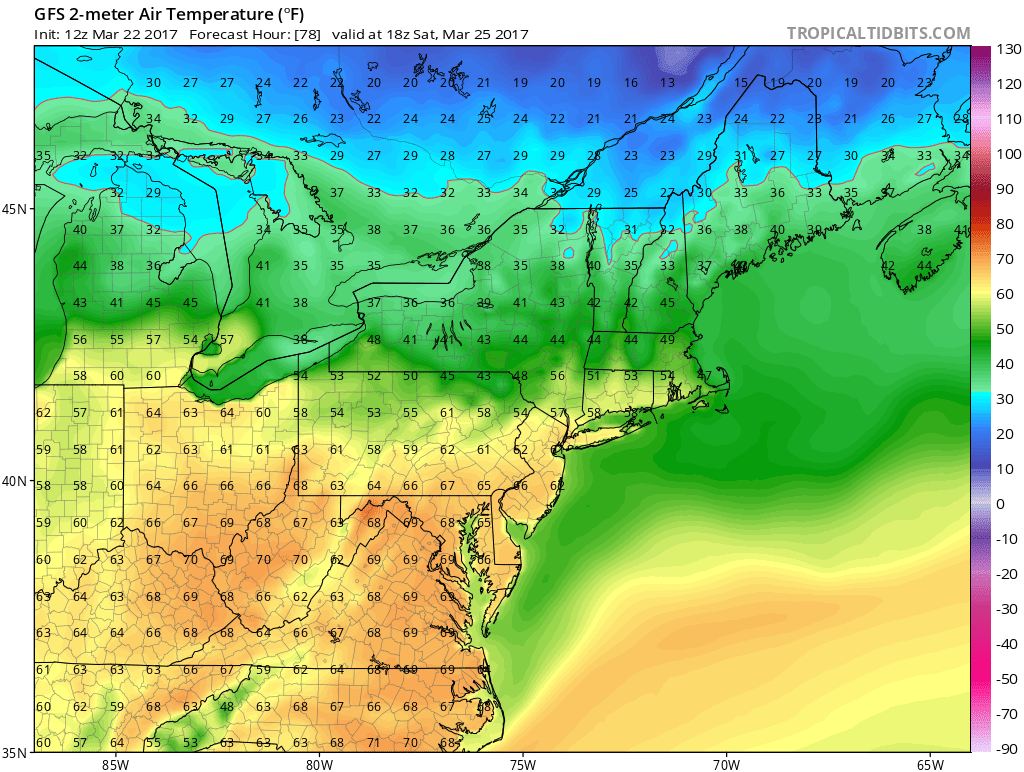
SPRING & BACKDOOR COLD FRONTS GFS 2PM SATURDAY
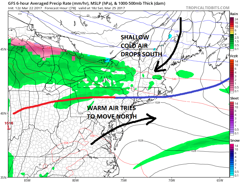
In the battles between shallow cold air and warm air, usually the cold air wins out and the backdoor fronts drop southward. This makes temperature forecasting for Saturday very difficult. The map above is for 2pm Saturday. It would suggest that areas to the south of the frontal zone will be in the 60s and 70s while to the north it’s in the 50s and 40s. You can see how close that boundary is at 2pm. It would certainly suggest that areas like Connecticut, the Hudson Valley, Northeast Pennsylvania and possibly Long Island (always an issue regardless) will be in the cooler air while Southeast Pennsylvania, New Jersey (except the extreme north) and points south will be in the warm air.
SPRING & BACKDOOR COLD FRONTS GFS 2PM SATURDAY TEMPERATURES
The next issue is Sunday and Monday. Low pressure in the Ohio Valley will move east with some rain. The northeast marine flow will be established so it looks like Sunday will be one of those gray miserable days with a cold rain and temperatures in the 40s.
SPRING AND BLOCKING FOR EARLY NEXT WEEK GFS JET STREAM MONDAY 3/27/2017

Blocking sets up in the North Atlantic but it is weak and transitory. This will force weather systems to pass near or just to our south early next week. The first on Sunday into Monday goes by and there is another right behind it and a third is behind that one coming into the west. This will probably lead to frequent chances for rain. Another shot comes in for late Tuesday and Wednesday as low pressure heads to the Eastern Lakes and redevelops near or just to our south. The third will follow with more rain later next week. Thankfully there is no cold air around to create any kind of issues for snow and ice, though some areas in Central and Northern New England could see some spring snow from this. Overall it looks like a typical early spring pattern. For parts of the South from Texas to the Middle and Lower Mississippi Valley it looks like severe weather will be an issue with the first round coming on Friday of this week and more chances next week as these systems cross the US.
MANY THANKS TO TROPICAL TIDBITS FOR THE WONDERFUL USE OF THE MAPS

GET JOE A CIGAR IF YOU LIKE!
SNOW REMOVAL COMPANIES FOR YOUR WINTER NEEDS
LONG ISLAND ROCKLAND COUNTY Connecticut

![]()

ROCKLAND COUNTY TRI STATE SNOW REMOVAL JOHNSTOWN PA


FiOS1 News Weather Forecast For Long Island
FiOS1 News Weather Forecast For New Jersey
FiOS1 News Weather Forecast For Hudson Valley
NATIONAL WEATHER SERVICE SNOW FORECASTS
LATEST JOESTRADAMUS ON THE LONG RANGE
Weather App

Don’t be without Meteorologist Joe Cioffi’s weather app. It is really a meteorologist app because you get my forecasts and my analysis and not some automated computer generated forecast based on the GFS model. This is why your app forecast changes every 6 hours. It is model driven with no human input at all. It gives you an icon, a temperature and no insight whatsoever.
It is a complete weather app to suit your forecast needs. All the weather information you need is right on your phone. Android or I-phone, use it to keep track of all the latest weather information and forecasts. This weather app is also free of advertising so you don’t have to worry about security issues with your device. An accurate forecast and no worries that your device is being compromised.
Use it in conjunction with my website and my facebook and twitter and you have complete weather coverage of all the latest weather and the long range outlook. The website has been redone and upgraded. Its easy to use and everything is archived so you can see how well Joe does or doesn’t do when it comes to forecasts and outlooks.
Just click on the google play button or the apple store button on the sidebar for my app which is on My Weather Concierge. Download the app for free. Subscribe to my forecasts on an ad free environment for just 99 cents a month.
Get my forecasts in the palm of your hand for less than the cost of a cup of Joe!
![]()
