
Spring Forward Warmup 70 Today
![]()
Day one of the spring forward warmup took us into the upper 50s and lower 60s in many locations except coastal areas of course. Now today we add on another 10 degrees to these numbers and shoot for upper 60s to lower 70s except again along coastal areas. The only issue regarding today will be occasional clouds that move through from time to time. You can see them on the satellite loop as they come up from Gulf States. Most of this is blow off from activity in the Middle Mississippi Valley.
Spring Forward Warmup 70 Today Satellite Loop


Radars are mostly quiet with the exception of a few sprinkles here and there. No showers or even sprinkles are in our forecast through Thursday.
Spring Forward Warmup 70 Today Local Radar Loops


Tonight will be warm with temperatures not falling far at all. Most lows will be in the 40s to near 50 and some warmer urban areas may never get below the mid 50s. This sets up the launching pad for Wednesday with sunshine and a west wind. Everyone should reach the 70s and it I don’t think it is is out of the question for some spots in New Jersey for example to hit the 80 degree mark. Even coastal locations could get to 70 before any sea breeze develops.
Spring Forward Warmup 70 Today Euro Model Thursday Night Surface Map
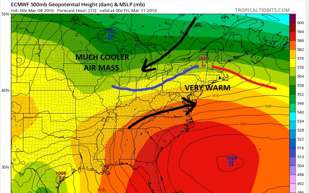
Longer range Im buying the Euro model idea of a cold front coming through here sometime early Friday. Thursday looks like it will be the last day of 70 plus temperatures before it cools off during Friday. The GFS model develops an onshore flow and a miserable weekend. The European DOES NOT DO THIS. Instead it brings the high to the north overhead and southward which means improving weather conditions Friday night and a half way decent Saturday before we get into clouds and showers on Sunday. I’m standing with the European’s idea as it has been far superior to the GFS model for quite awhile in catching trends in the medium range forecast period.
FiOS1 News Weather Forecast For Long Island
FiOS1 News Weather Forecast For New Jersey
FiOS1 News Weather Forecast For Hudson Valley
NATIONAL WEATHER SERVICE SNOW FORECASTS
LATEST JOESTRADAMUS ON THE LONG RANGE
Weather App

Don’t be without Meteorologist Joe Cioffi’s weather app. It is really a meteorologist app because you get my forecasts and my analysis and not some automated computer generated forecast based on the GFS model. This is why your app forecast changes every 6 hours. It is model driven with no human input at all. It gives you an icon, a temperature and no insight whatsoever.
It is a complete weather app to suit your forecast needs. All the weather information you need is right on your phone. Android or I-phone, use it to keep track of all the latest weather information and forecasts. This weather app is also free of advertising so you don’t have to worry about security issues with your device. An accurate forecast and no worries that your device is being compromised.
Use it in conjunction with my website and my facebook and twitter and you have complete weather coverage of all the latest weather and the long range outlook. The website has been redone and upgraded. Its easy to use and everything is archived so you can see how well Joe does or doesn’t do when it comes to forecasts and outlooks.
Just click on the google play button or the apple store button on the sidebar for my app which is on My Weather Concierge. Download the app for free. Subscribe to my forecasts on an ad free environment for just 99 cents a month.
Get my forecasts in the palm of your hand for less than the cost of a cup of Joe!
![]()
![]()
<