Spring Continues To Torture Northeast When Does It End?

Weather in 5/Joe & Joe Weather Show Latest Podcast
Spring Continues To Torture Northeast When Does It End?
It has always amazed me that many folks seem to think that spring is this wonderful time of year. Breaking news folks, it isn’t and it never has been. Only in the rarest of springs do we get this sort of sing song of endless sunshine complete with birds chirping and warm weather that embraces you on a daily basis. This has always been a fairy tale or the stuff of legend.
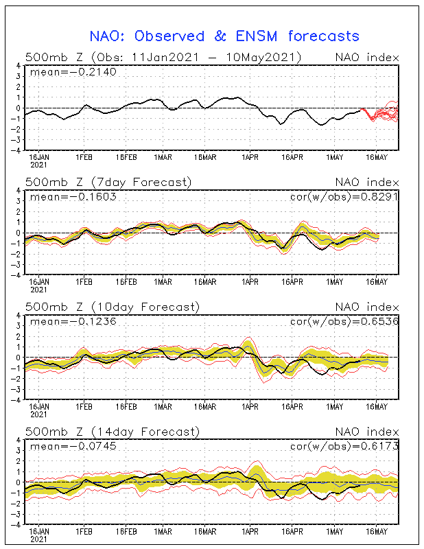
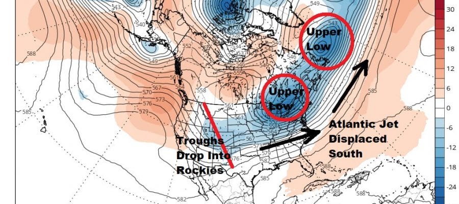
Think back to the warmer than normal mostly uneventful month of March and we had the North Atlantic Oscillation or NAO positive which means lower than normal pressures in the North Atlantic. Weather systems tend to move along in this set up. Since mid April we have reversed this as the NAO went negative and is forecast to remain negative possibly for the next 2 weeks. Higher than normal pressures in the North Atlantic displace the jet stream further south and that also puts us in a not so good place overall.

Troughs meanwhile keep dropping into the Rockies where winter keeps hanging on in some areas. The Pacific North America index is not in a good place for the Eastern US as it is negative and goes strongly negative for the rest of the month.

Normally the negative PNA would mean ridging in the Eastern US but the negative NAO is offsetting this and it will attempt to set up battle ground zones somewhere across the Eastern US in the longer term. What we need to hope for is for the NAO to win out and suppress this potential battle ground zone further south. The downside to this is that it will continue the trend of below average temperatures in the long range. Warm ups will be restricted to odd days here and there when highs go out to the south. That leaves us with back door cold front potential to cut off any serious warming.
Models have been suggesting some warming was possible later this weekend or early into next week but the orientation of the surface has changed. The current big high goes out to our east rather than to the south which sets up more of southeast flow early next week instead of west or southwest. Add to that another round of northern jet stream energy and you can wave any significant warm up good bye. Behind that is another cool high coming down from Canada. One positive note is that the normal temperatures continue to rise so that eventually those cool highs will still mean daytime temperatures perhaps reaching into the 70s but if you are looking for 80s on a longer term basis you will have to wait awhile.

BE SURE TO DOWNLOAD THE FREE METEOROLOGIST JOE CIOFFI WEATHER APP &
ANGRY BEN’S FREE WEATHER APP “THE ANGRY WEATHERMAN!
MANY THANKS TO TROPICAL TIDBITS FOR THE USE OF MAPS
Please note that with regards to any severe weather, tropical storms, or hurricanes, should a storm be threatening, please consult your local National Weather Service office or your local government officials about what action you should be taking to protect life and property.