
Some Sunshine Today Chilly Sunday Monday Warm Up Tuesday
Some Sunshine Today Chilly Sunday Monday Warm Up Tuesday
This is going to be the better of the two weekend days no doubt with the low clouds and fog burning off to some sunshine and highs will reach the upper 60s and lower 70s. We are in between two systems with yesterday’s system to the northeast and a second system now moving across the Great Lakes and heading into Western New York. A cold front with this won’t arrive until later tonight and showers should probably hold off until later this evening.
US SATELLITE

REGIONAL RADAR

We are beginning to see some showers from the cold front moving into Western Pennsylvania and those showers will gradually make eastward progress but they have a long way to go before getting here. Local radars are quiet this morning but should start picking up on the showers to the west later this afternoon.
LOCAL RADAR NEW YORK CITY

LOCAL RADAR PHILADELPHIA


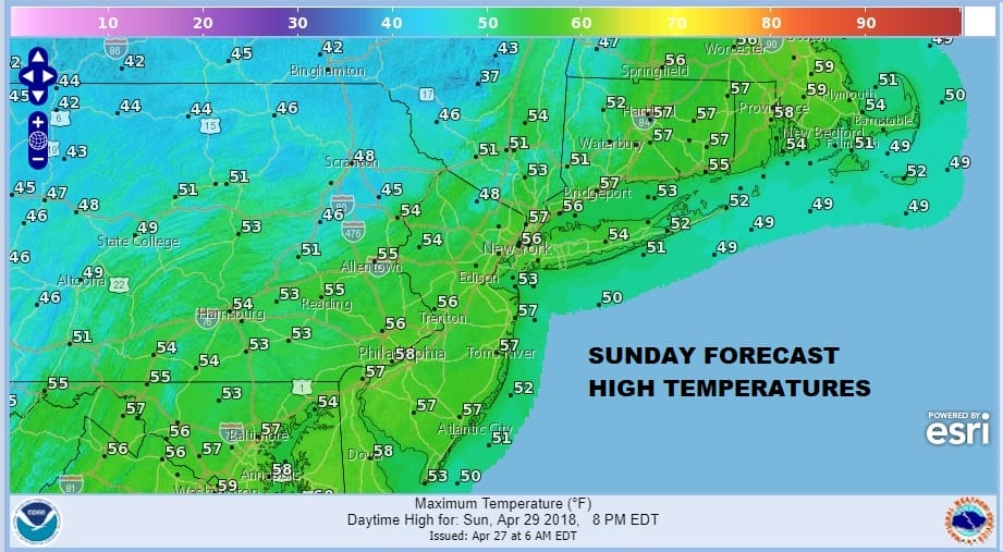
Once the front passes tonight it sets us up for a chilly Sunday and Monday with lots of developing clouds and the chance for afternoon and evening scattered showers on Sunday. The temperatures will be chilly with highs just in the 50s.
Sunday night into Monday morning another spoke of energy rotates around an upper air storm to the north so there could be another shower or two early Monday morning. Temperatures are going to be quite chilly with Monday morning lows in the upper 30s and lower 40s. Clouds will be hanging tough on Monday with most highs in the 50s.

Finally on Tuesday warm air arrives with sunshine and temperatures should climb into the 70s. We are still on course for 80s Wednesday and Thursday with some sunshine both days.
 GET JOE A CIGAR IF YOU LIKE

FiOS1 News Weather Forecast For Long Island
FiOS1 News Weather Forecast For New Jersey
FiOS1 News Weather Forecast For Hudson Valley


