Some Showers Tonight Dry Wednesday Some Showers Wednesday Night

Some Showers Tonight Dry Wednesday Some Showers Wednesday Night
Clouds rolled in a bit faster today than advertised though we did have some sun in the mix. Radars are picking up some rain that is not reaching the ground this evening but here are some showers to the west that are moving east. This area is forecast to weaken as it approaches and crosses Eastern Pennsylvania to Southern New England but we will leave in the chance for some scattered showers tonight. The highest chance would be from 7pm to 1am. Skies should partially clear after that with lows in the upper 20s to mid 30s.
SATELLITE

WEATHER RADAR

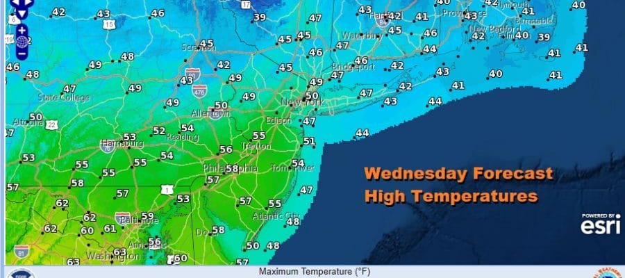
Wednesday we should see some sunshine though once again another cold front and upper trough will be approaching. Look for clouds to move in during the afternoon. Highs will be in the upper 40s to around 50 in northern areas but to the south we will see middle and even some upper 50s due to more sunshine and fewer clouds.

Another cold front and another chance for a passing shower is forecast Wednesday night. Thursday will be a breezy chilly day with some sunshine but highs will be in the low and middle 40s and then down to the 20s at night. Friday will be a dry cold day with sunshine. Most highs will be in the upper 30s to lower 40s.
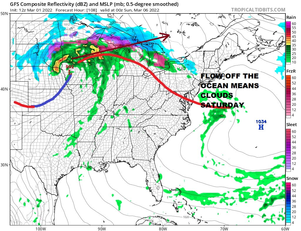
We have a storm this weekend in the Plains that is headed to the Northern Great Lakes. It tracks so far west that we miss out on any steady precipitation as most of that will be well to our north. We will however have a warm front to our south and an ocean wind and that makes for a cloudy Saturday. Highs will be in the raw 50s. Sunday will hinge on that warm front going to our north and this time of year fronts can be stubborn to do that. So for now we will go with clouds around and temperatures will be in the mid 50s to lower 60s. Showers from the cold front seem to be a good bet around midday into the afternoon. Another system follows for early next week.
BE SURE TO DOWNLOAD THE FREE METEOROLOGIST JOE CIOFFI WEATHER APP &
ANGRY BEN’S FREE WEATHER APP “THE ANGRY WEATHERMAN!
MANY THANKS TO TROPICAL TIDBITS & F5 WEATHER FOR THE USE OF MAPS
Please note that with regards to any severe weather, tropical storms, or hurricanes, should a storm be threatening, please consult your local National Weather Service office or your local government officials about what action you should be taking to protect life and property.


