Some Rain Over The Weekend Quick Cold Shot Arrives Monday

Weather in 5/Joe & Joe Weather Show Latest Podcast
Some Rain Over The Weekend Quick Cold Shot Arrives Monday
We are finishing off the week on the chilly side but it is warm enough to continue the snow melt. The satellite picture shows the snow cover in the milky gray while the brighter white higher clouds to the west and south will begin to increase as we go through the rest of today. HI.ghs this afternoon should reach the low and mid 40s;
SATELLITE

While both regional radars aren’t showing much in the way of precipitation at the moment keep an eye on the Middle Atlantic regional radar as that should start to see action pick up across Kentucky and Virginia later today. That is our precipitation that will arrive tonight.
F5 WEATHER RADARS


In the meantime some cold air will still be around over some inland areas in Northeastern Pennsylvania, Northwest New Jersey to the Catskills and the Hudson Valley. These areas could see precipitation briefly start off as some snow overnight but it will go over to rain rather fast and it should not amount to much. When you wake up Saturday morning it should be raining just about everywhere.

Saturday will be a rather gloomy day with this area of rain overhead but it should move out during the morning to early afternoon from south to north. Then we will likely just sit in clouds for the remainder of the day. Some brightening is possible or even a break or two of sun. Highs will be in the upper 40s to mid 50s. Clouds will linger Saturday night and then we have another wave and cold front approaching. Sunday will be cloudy with another shot for rain in the afternoon into the evening. Highs again will be in the upper 40s to mid 50s.

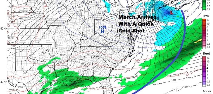
March arrives with a quick shot of cold air and an arctic front. Monday we will see leftover highs in the 50s early before the cold air begins to arrive later in the day and especially Monday night. There might be a quick snow shower or even a snow squall as the upper trough swings through. A storm develops east of Cape Cod bringing some snow to Eastern New England. We turn colder and lows Tuesday morning will be in the upper teens to mid 20s with a gusty wind. Tuesday look for sunshine but it will be cold with highs just in the 30s. After Tuesday there are big model differences with the GFS model showing nothing happening all week. Other models are showing a completely different upper air set up, especially the European which would argue for a low moving across the south and heading up the coast for late Wednesday or Thursday. This would be a mostly a cold rain event if it occurs. We will be examining this prospect over the weekend.
BE SURE TO DOWNLOAD THE FREE METEOROLOGIST JOE CIOFFI WEATHER APP &
ANGRY BEN’S FREE WEATHER APP “THE ANGRY WEATHERMAN!

MANY THANKS TO TROPICAL TIDBITS & F5 WEATHER FOR THE USE OF MAPS
Please note that with regards to any severe weather, tropical storms, or hurricanes, should a storm be threatening, please consult your local National Weather Service office or your local government officials about what action you should be taking to protect life and property.


