Some Improvement Today As Coastal Low Moves Away
Weekend Has Small Shower Chance Saturday

Some Improvement Today As Coastal Low Moves Away
Weekend Has Small Shower Chance Saturday
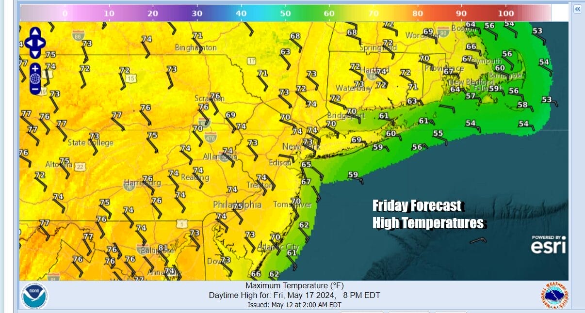
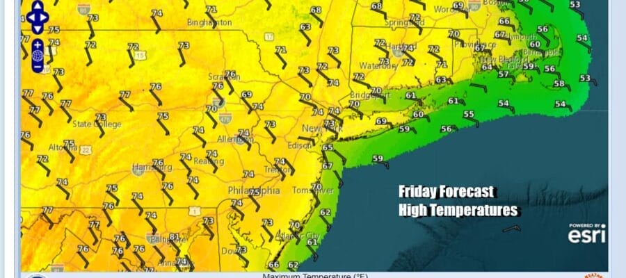
We are still seeing the midweek coastal low offshore rotating in counterclockwise fashion and producing leftover low clouds mainly along the coast. The low is forecast to slide southeastward today and that will allow for decreasing clouds and increasing amounts of sunshine. Winds will still be coming in from off the ocean but the onshore flow is rather weak. With developing sunshine, temperatures should reach the upper 60s and lower 70s for highs from the cooler coastal areas to the warmer inland locations. Even though the upper low is close by, radars are quiet for the most part and there should be no rain issues today.
SATELLITE WITH LIGHTNING STRIKES

WEATHER RADAR

Another low pressure area and associated upper low is moving across the Lower Ohio & Tennessee Valley. This system follows a similar path as yesterday’s low but there is enough of a westerly flow across Southern Canada and New England to suppress this low further south. This leads us to have a more optimistic view for the weekend overall, though we will have some issues for Saturday.

Showers from this system will approach on Saturday so there will likely be clouds around. We expect some scattered showers to be around Saturday though it is possible that many areas may miss them and any rain will be minimal. We will probably see some breaks of sun in there as well especially for areas to the north and northeast of NYC. Temperatures Saturday will be in the upper 60s and lower 70s.

The low and its associated shower activity will pushed to the south Saturday evening and Saturday night, lying mainly across the Mid Atlantic from Virginia and North Carolina southward. This should allow for improvement and Sunday will be the better of the two weekend days. Sunday should be no worse than partly sunny and temperatures Sunday will reach into the low and middle 70s.

Next week we will see something that hasn’t happened much since early April. We will strong 2 and possibly 3 dry days in a row. The next weather front doesn’t appear to get close until next Wednesday night or Thursday. Monday and Tuesday we should see no worse than partly sunny skies. Inland highs will be in the mid to upper 70s both days and of course we will be cooler along the immediate coast thanks to a south wind.
BE SURE TO DOWNLOAD THE FREE METEOROLOGIST JOE CIOFFI WEATHER APP &
ANGRY BEN’S FREE WEATHER APP “THE ANGRY WEATHERMAN!
MANY THAiKS TO TROPICAL TIDBITS FOR THE USE OF MAPS
Please note that with regards to any severe weather, tropical storms, or hurricanes, should a storm be threatening, please consult your local National Weather Service office or your local government officials about what action you should be taking to protect life and property.
(Amazon is an affilate of Meteorologist Joe Cioffi & earns commissions on sales.)


