The Weekend Not Perfect But Not Terrible Week Ahead Outlook

The Weekend Not Perfect But Not Terrible Week Ahead Outlook

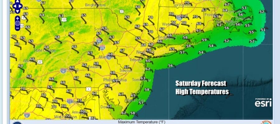
Over the last 50 days much of the area has seen as many as 35 days of rain! Not all of those days were whole day washouts but it seems we are catching a bit of a break this weekend. There is a weakening front approaching today as well as low pressure passing to the south. Showers on the radar to the west and north continue to weaken while an area of heavy rain to the south in the Mid Atlantic states is moving more to the east and not to the north. This leaves us in a place where we will include the chance for a scattered shower or two today, but most of the area will just be in what I would describe as cloudy to occasionally partly sunny conditions. Winds are coming in from off the ocean and that will keep temperatures in check today as highs reach the upper 60s and lower 70s.
SATELLITE WITH LIGHTNING STRIKES

WEATHER RADAR

As these two weather systems continue to weaken we should see a mix of clouds and some clear skies tonight with lows mostly in the 50s. Sunday should be no worse than partly sunny everywhere as weak high pressure along the coast holds on. More sun should mean that temperatures will move higher and reach into the 70s especially inland.

Next week brings a pattern shift where the upper trough position moves back into the Plains and Midwest. Severe weather risks will shift there as well and that includes a day of possible widespread risk for the Midwest Tuesday. Here in the East high pressure moves off the coast and winds turn more south and southwest and that should allow for temperatures to warm up.

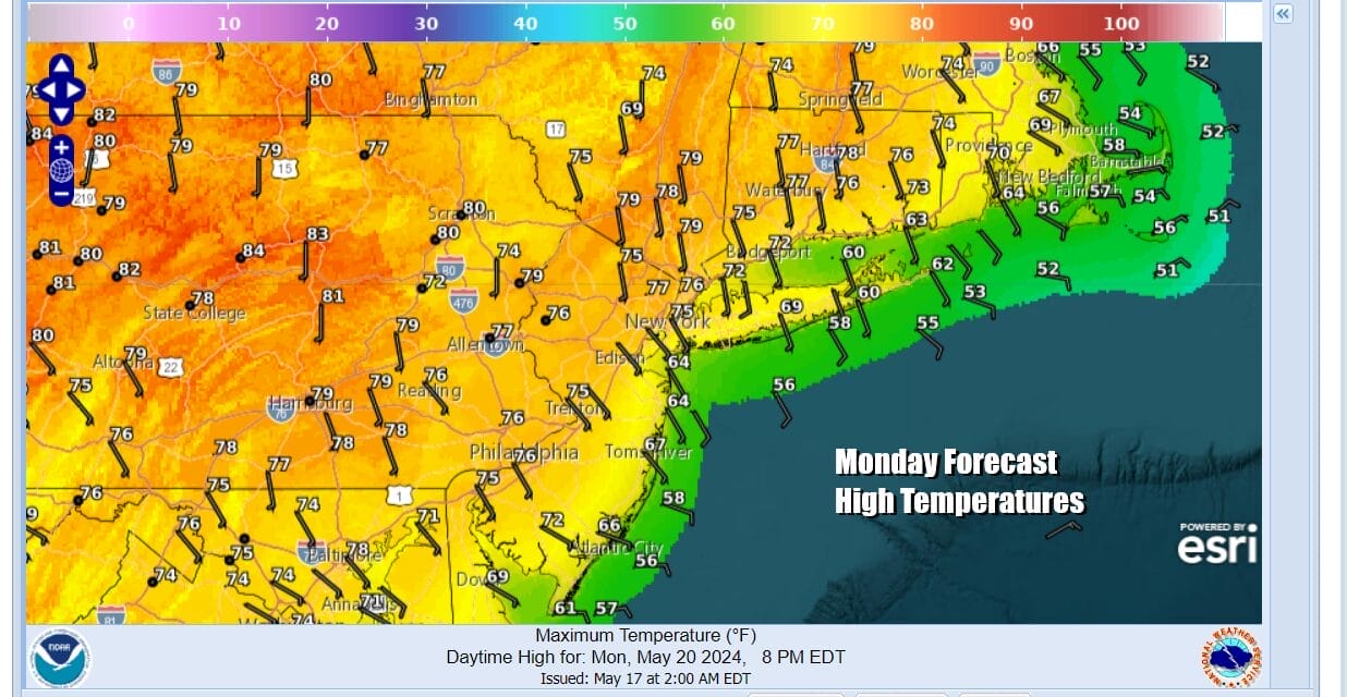
Monday should be a nice day of sunshine. There will be a south wind in play so that will keep temperatures down somewhat near the coast but highs should reach the 70s along south and east facing shorelines while inland highs should be able to take temperatures up through the 70s with some 80 degree highs inland.
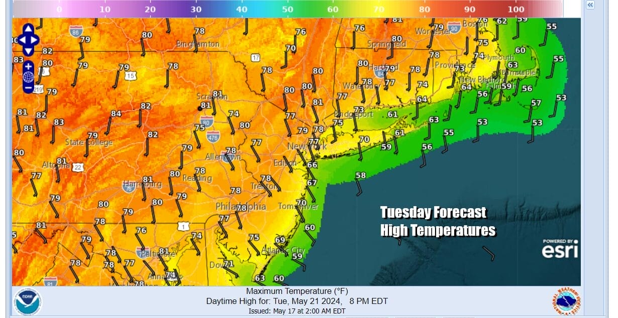
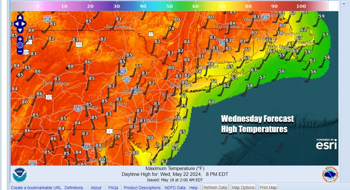
The next cold front probably doesn’t get anywhere close until Wednesday night or Thursday so that leaves us with two days of sunshine and even warmer temperatures for Tuesday and Wednesday. Winds will turn more south to southwest on both days and that should allow temperatures to reach the 80s inland both Tuesday and Wednesday. Both days will be a little cooler along south and east facing shorelines. More importantly no rain is forecast!
We will still be holding on to the 80s for Thursday but this will also come with a cold front nearing the coast and some showers and possible thunderstorms developing later in the day. Friday brings a return to dry weather and sunshine with highs in the 70s to near 80 degrees. Next weekend is the Memorial Day holiday weekend which is considered the first weekend of the summer vacation season. Typically this is the one weekend of the 3 summer holidays where you are likely to see rain on at least one of the three days and right now in the land of early speculation, it would seem that Saturday and Monday Memorial Day will be dry with some questions for Sunday as a weather front approaches. However we have see models vacillate back and forth on the holiday weekend over the last several days so it may be another two or three days before we have a better handle on things.
BE SURE TO DOWNLOAD THE FREE METEOROLOGIST JOE CIOFFI WEATHER APP &
ANGRY BEN’S FREE WEATHER APP “THE ANGRY WEATHERMAN!
MANY THANKS TO TROPICAL TIDBITS FOR THE USE OF MAPS
Please note that with regards to any severe weather, tropical storms, or hurricanes, should a storm be threatening, please consult your local National Weather Service office or your local government officials about what action you should be taking to protect life and property.
(Amazon is an affilate of Meteorologist Joe Cioffi & earns commissions on sales.)


