
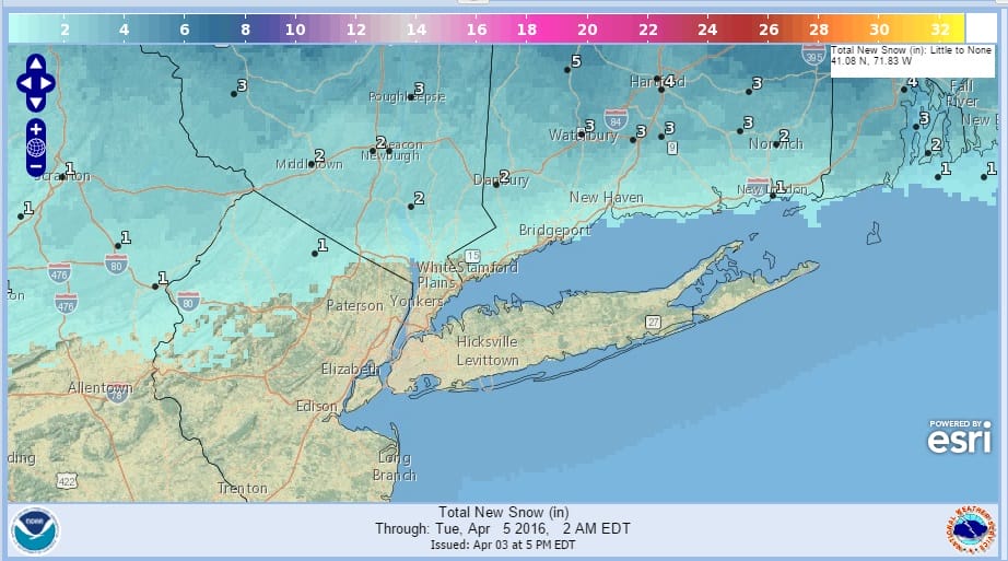
Snowfall Forecast Biggest Of 2016 For Some Areas!
Snowfall forecast maps are updated from the National Weather Service for snow tonight through Monday evening. The main emphasis is north of the coast. The funny thing is that for many areas in upstate New York and New England, this 2 to 6 inch snowfall could be the biggest single snowfall of the winter/spring season combination! Winter Weather Advisory is in effect in New York and Connecticut north of route 84. In fact many cities experienced their lowest winter snowfalls on record. It is possible that this snowfall could take some of those cities out of that particular distinction. To see a less than a 6 inch snowfall in April wind up being the winter’s biggest for some is truly remarkable. It also shows just how lacking the snowfall was during the November to March time frame. The limited moisture and the lack of any kind of serious storm development prevents this from being anything other than a minor snowfall. Record cold temperatures will follow Tuesday morning with lows in the teens to near 20 in most areas and even a few single digits are not out of the question.
Snowfall Forecast Biggest Of 2016 For Some Areas!
NATIONAL WEATHER SERVICE SNOWFALL FORECAST
Snowfall Forecast Biggest Of 2016 For Some Areas!
NATIONAL WEATHER SERVICE SNOWFALL FORECASTS
NEW YORK CITY AND VICINITY SNOW

NEW JERSEY & PARTS OF NE PA

SOUTHERN AND SOUTHEAST NEW ENGLAND

NORTHERN NEW ENGLAND
WESTERN NEW ENGLAND

MIDDLE AND UPPER HUDSON VALLEY
CENTRAL NEW YORK & NE PA

WESTERN NEW YORK

CENTRAL & SOUTH CENTRAL PA

VIRGINIA & MARYLAND

DAILY NORTHEAST SNOWFALL

Please be advised that these are National Weather Service Forecast Maps and they auto update. Each office may update at different times and some offices are slower to update then others. Maps are usually updated before 5am and & 5pm however they may be updated at other times depending on forecast conditions.