Snow Threat Saturday Coastal Areas

Snow Threat Saturday Coastal Areas
All Models Shift Westward
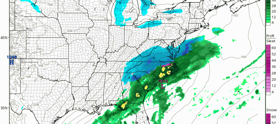
Beginning with the NAM model overnight and then joined by the GFS, Canadian, and European Models, the storm forecast off the southeast coast of the US has shifted significantly westward. The NAM model had the most dramatic shift taking snow well north and west of the coast.
NAM MODEL FORECAST SATURDAY CLICK TO ANIMATE
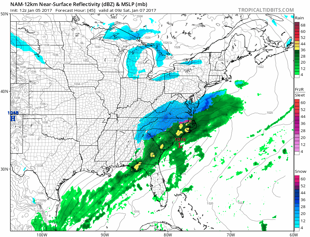
This isn’t even the most extreme west solutions as some of the other variations of the NAM went even further north and west. With all the other models trending west the question is whether the trend will continue this afternoon with the next model cycle. Why the shift westward?
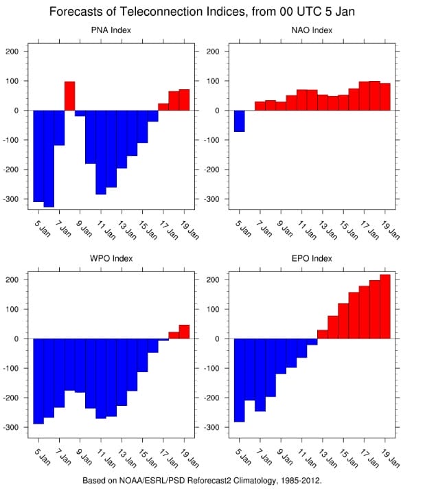
Two things are happening that I believe are very important with regards to blocking and the ridge in the west. The North Atlantic Oscilliation which was in an extreme position is going rapidly to neutral. In other words blocking in the Atlantic is collapsing. At the same time the Pacific North America pattern which has been in an extreme negative position is punching to positive this weekend for a brief time. When the PNA is positive it promotes a ridge in the west which intensifies the upper air trough in the east. Those two changes are occurring literally at the last minute. It is possible that the westward shift is not done yet. The NAM model was the first to smell this out yesterday as it began pivoting the coastal low more north northeast south southwest. Now what does this mean for additional snow? Right now I would say that the threat is going to be for Coastal New Jersey and Long Island. I think given these developments they stand the best chance to see snow Saturday into Saturday night. Places west and north of the Garden State Parkway would see far less as well as areas just west and north of New York City. My early call on this 2 days ago I think is how I would like to go at this point for Saturday.
SNOW JOE’S EARLY CALL FOR SATURDAY
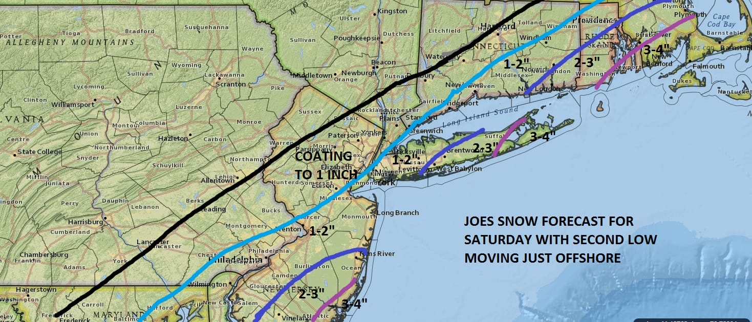
Now please bear in mind that if models continue to shift westward, it would not take much to double these amounts or even more. It is important to see whether this westward shift will continue or are models still in catch up mode. Also tonight’s event will be critical to see which model handles it the best in terms of outcome. So far at least it appears the NAM model has opened up a lead over the others.
MANY THANKS TO TROPICAL TIDBITS FOR THE WONDERFUL USE OF THE MAPS
SNOW REMOVAL COMPANIES FOR YOUR WINTER NEEDS
LONG ISLAND ROCKLAND COUNTY Connecticut

![]()

ROCKLAND COUNTY TRI STATE SNOW REMOVAL JOHNSTOWN PA


FiOS1 News Weather Forecast For Long Island
FiOS1 News Weather Forecast For New Jersey
FiOS1 News Weather Forecast For Hudson Valley
NATIONAL WEATHER SERVICE SNOW FORECASTS
LATEST JOESTRADAMUS ON THE LONG RANGE
Weather App

Don’t be without Meteorologist Joe Cioffi’s weather app. It is really a meteorologist app because you get my forecasts and my analysis and not some automated computer generated forecast based on the GFS model. This is why your app forecast changes every 6 hours. It is model driven with no human input at all. It gives you an icon, a temperature and no insight whatsoever.
It is a complete weather app to suit your forecast needs. All the weather information you need is right on your phone. Android or I-phone, use it to keep track of all the latest weather information and forecasts. This weather app is also free of advertising so you don’t have to worry about security issues with your device. An accurate forecast and no worries that your device is being compromised.
Use it in conjunction with my website and my facebook and twitter and you have complete weather coverage of all the latest weather and the long range outlook. The website has been redone and upgraded. Its easy to use and everything is archived so you can see how well Joe does or doesn’t do when it comes to forecasts and outlooks.
Just click on the google play button or the apple store button on the sidebar for my app which is on My Weather Concierge. Download the app for free. Subscribe to my forecasts on an ad free environment for just 99 cents a month.
Get my forecasts in the palm of your hand for less than the cost of a cup of Joe!
![]()


