
Snow Spreading Northward

MENTION JOE CIOFFI AND GET A 5% DISCOUNT
Radar and Satellite loops this afternoon are beginning to show precipitation developing to the south and spreading slowly northward. We are at the point now where we will just watch the satellite, radar, and surface observations and see how this all plays out. Frankly I would have liked to see a more impressive looking radar and satellite presentation but it is tough when the precipitation is literally developing overhead. We will watch things carefully over the next few hours. This should determine how this all plays out tonight.
Snow Spreading Northward SATELLITE LOOP

Snow Spreading Northward REGIONAL RADAR LOOP

Snow Spreading Northward LOCAL RADAR LOOPS


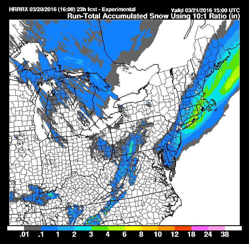
Some of the shorter range models have become a little less bullish on the amount of precipitation forecast overnight. They actually cut amounts in half a few hours ago but then in the last hour they seem to have come back a bit. Here is the latest super short range HRRR model snowfall forecast. It shows highest amounts over Long Island but it has lowered amounts along the New Jersey shore. Bear in mind that this model runs every hour so it will change as we move into the evening hours.
Snow Spreading Northward HRRR MODEL SNOWFALL FORECAST
Once the snow is done it will melt rapidly Monday morning on the roads and they should be clear and wet by 8am or so and much of the snow will be gone by the end of the day. Temperatures tonight while it is snowing will be near or below freezing and rise into the 40s quickly on Monday with increasing amounts of sunshine. After a cold Monday night, Tuesday we will see sunshine and highs into the 50s. Longer range Wednesday and Thursday we are headed for the 60s and 70 is not out of the question on Thursday with some sunshine on both days.
FiOS1 News Weather Forecast For Long Island
FiOS1 News Weather Forecast For New Jersey
FiOS1 News Weather Forecast For Hudson Valley
NATIONAL WEATHER SERVICE SNOW FORECASTS
LATEST JOESTRADAMUS ON THE LONG RANGE
Weather App

Don’t be without Meteorologist Joe Cioffi’s weather app. It is really a meteorologist app because you get my forecasts and my analysis and not some automated computer generated forecast based on the GFS model. This is why your app forecast changes every 6 hours. It is model driven with no human input at all. It gives you an icon, a temperature and no insight whatsoever.
It is a complete weather app to suit your forecast needs. All the weather information you need is right on your phone. Android or I-phone, use it to keep track of all the latest weather information and forecasts. This weather app is also free of advertising so you don’t have to worry about security issues with your device. An accurate forecast and no worries that your device is being compromised.
Use it in conjunction with my website and my facebook and twitter and you have complete weather coverage of all the latest weather and the long range outlook. The website has been redone and upgraded. Its easy to use and everything is archived so you can see how well Joe does or doesn’t do when it comes to forecasts and outlooks.
Just click on the google play button or the apple store button on the sidebar for my app which is on My Weather Concierge. Download the app for free. Subscribe to my forecasts on an ad free environment for just 99 cents a month.
Get my forecasts in the palm of your hand for less than the cost of a cup of Joe!
![]()
![]()
<