Snow Showers Into Monday
Snow Showers Into Monday
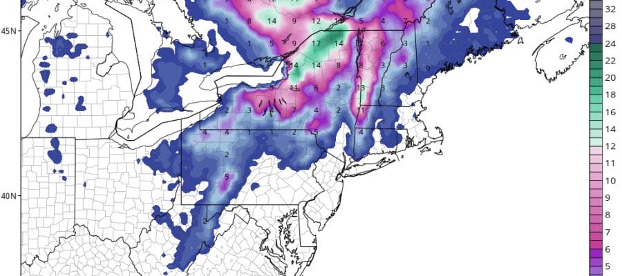
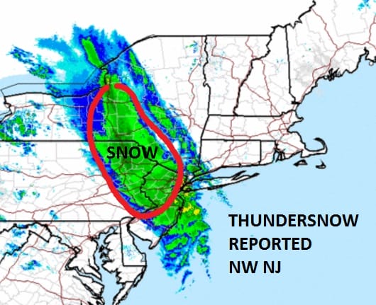
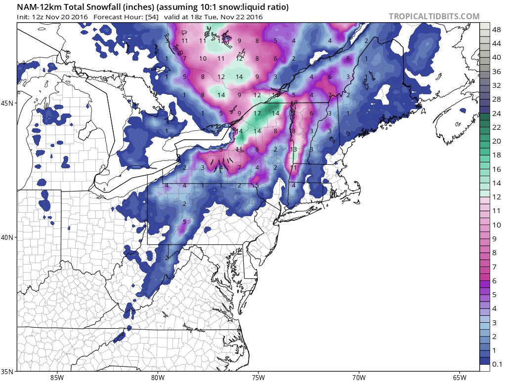
After last night’s snow show that produced anywhere from a coating to 1/2 a foot from Northeastern Pennsylvania and Northwest New Jersey northeastward into the Hudson Valley. It came with lightning and thunder, strong winds, and blinding snows. It was quite the surprise in terms of the magnitude. Considering that it was in the 60s to near 70 just hours before the snowfall was even more amazing.
Snow reports as of 9:30am as reported by the National Weather Service
LOCATION          STORM TOTAL     TIME/DATE   COMMENTS
                     SNOWFALL           OF
                     /INCHES/   MEASUREMENT

CONNECTICUT

...FAIRFIELD COUNTY...
   NEW CANAAN             0.6   543 AM 11/20  TRAINED SPOTTER
   SHELTON                0.3   720 AM 11/20  PUBLIC

NEW JERSEY

...ESSEX COUNTY...
   CEDAR GROVE            0.5   300 AM 11/20  PUBLIC

...PASSAIC COUNTY...
   WEST MILFORD           4.5   330 AM 11/20  1100 FT ELEVATION.

NEW YORK

...ORANGE COUNTY...
   SALISBURY MILLS        5.0   825 AM 11/20  PUBLIC
   2 NW WEST POINT        4.0   145 AM 11/20  TRAINED SPOTTER
   KIRYAS JOEL            3.6   815 AM 11/20  PUBLIC
   ORANGE LAKE            3.0   715 AM 11/20  TRAINED SPOTTER
   NEW WINDSOR            3.0   715 AM 11/20  PUBLIC
   FLORIDA                2.5   700 AM 11/20  PUBLIC

...WESTCHESTER COUNTY...
   POUND RIDGE            1.5   730 AM 11/20  TRAINED SPOTTER
The storm that developed just south of Long Island on the cold front has now moved up into Northern New England and now the lake effect snow machine takes over. Radars are showing increasing activity from that respect in upstate NY. Northeastern NY and Vermont are getting snow from the intensifying storm.
Meanwhile back here at home it is a windy cold and cloudy day with temperatures just into the 40s and win gusts to 30 to 40 mph. Weather models are showing increasing snow shower activity possibly developing tonight into Monday. Any of those snow showers could whiten the ground in spots.


Cold weather will be with us pretty much into midweek. Tonight we will see clouds and some scattered snow showers with lows in the upper 20s to lower 30s. Monday look for windy conditions at times with clouds and some sun and scattered snow showers with highs only in the upper 30s to middle 40s. We should see more sun and fewer clouds on Tuesday with highs in the 40s.
Longer term Wednesday we will see sunshine giving way to arriving clouds with highs in the 40s. The next weather system approaches with some rain later Wednesday night into Thanksgiving day. If precipitation arrives fast enough it could start as some snow or sleet especially as you head north and northwest.
SNOW REMOVAL COMPANIES FOR YOUR WINTER NEEDS
LONG ISLAND ROCKLAND COUNTY Connecticut

![]()

FiOS1 News Weather Forecast For Long Island
FiOS1 News Weather Forecast For New Jersey
FiOS1 News Weather Forecast For Hudson Valley
NATIONAL WEATHER SERVICE SNOW FORECASTS
LATEST JOESTRADAMUS ON THE LONG RANGE
Weather App

Don’t be without Meteorologist Joe Cioffi’s weather app. It is really a meteorologist app because you get my forecasts and my analysis and not some automated computer generated forecast based on the GFS model. This is why your app forecast changes every 6 hours. It is model driven with no human input at all. It gives you an icon, a temperature and no insight whatsoever.
It is a complete weather app to suit your forecast needs. All the weather information you need is right on your phone. Android or I-phone, use it to keep track of all the latest weather information and forecasts. This weather app is also free of advertising so you don’t have to worry about security issues with your device. An accurate forecast and no worries that your device is being compromised.
Use it in conjunction with my website and my facebook and twitter and you have complete weather coverage of all the latest weather and the long range outlook. The website has been redone and upgraded. Its easy to use and everything is archived so you can see how well Joe does or doesn’t do when it comes to forecasts and outlooks.
Just click on the google play button or the apple store button on the sidebar for my app which is on My Weather Concierge. Download the app for free. Subscribe to my forecasts on an ad free environment for just 99 cents a month.
Get my forecasts in the palm of your hand for less than the cost of a cup of Joe!


