Snow Showers Firing Up Again Nice Friday Through Sunday
Snow Showers Firing Up Again Nice Friday Through Sunday
Another upper air disturbance is firing up some snow showers across Pennsylvania and areas to the south this afternoon. Up until now we have seen a fair amount of sunshine but clouds will be moving in and we could see some scattered snow showers again this evening and into the first part of tonight. It may be warm enough in some areas for just plain rain showers as well as temperatures were able to warm up today into the 40s everywhere. This doesn’t appear to be as widespread as yesterday and not all areas will see them. Once they go by skies will clear tonight and temperatures will drop to the mid 20s to lower 30s by morning. The satellite shows clouds coming in from the west with the next disturbance.
US SATELLITE

REGIONAL RADAR

LOCAL RADAR NEW YORK CITY

LOCAL RADAR PHILADELPHIA


Friday looks like a nice day with sunshine and some occasional clouds mixing in but no snow showers. Highs will be in the upper 30s to around 40 or so. The weekend overall looks good with sunshine for Saint Patrick’s Day but clouds from a weak disturbance could be an issue especially over Southern New Jersey and Southeastern Pennslyvania southward but any rain should stay well south. Highs will reach the 40s to near 50. Sunday looks good with lots of sunshine and colder again with highs in the low to mid 40s.
GFS MODEL WEDNESDAY MARCH 21, 2018 8AM
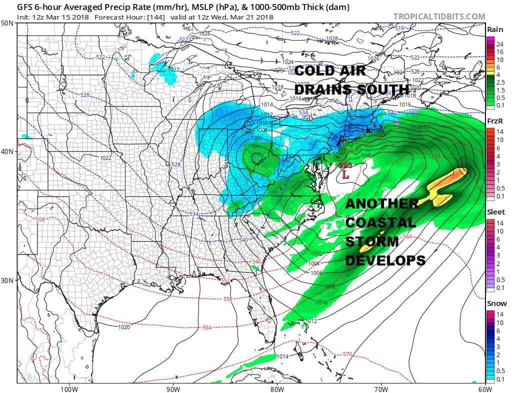
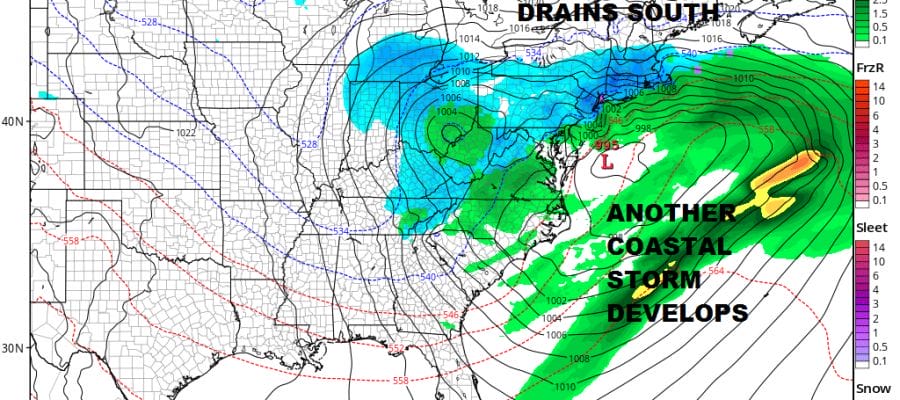
Weather models are all showing a complex pattern for next week which will result in another coastal storm but this one will be different. There is a lot of energy running around in the atmosphere which probably means this storm will not be the intense gale centers the last 3 storms were. However this doesn’t mean there won’t be some impact. Cold air will be draining southward so snow is once again in play. Models have been trending colder and further south the last 2 days. Also the complex nature of the upper air pattern suggests a long duration event beginning during Tuesday with perhaps a second wave coming into play Wednesday into early Thursday. This makes the forecast more complicated than usual and the uncertainty level remains high. We will be examining all the models closely and we will discuss this further later today.
 GET JOE A CIGAR IF YOU LIKE

FiOS1 News Weather Forecast For Long Island
FiOS1 News Weather Forecast For New Jersey
FiOS1 News Weather Forecast For Hudson Valley


