
Snow Showers Around Today, Heavy Rain Strong Winds
Late Sunday into Early Monday

Snow Showers Around Today, Heavy Rain Strong Winds
Late Sunday into Early Monday
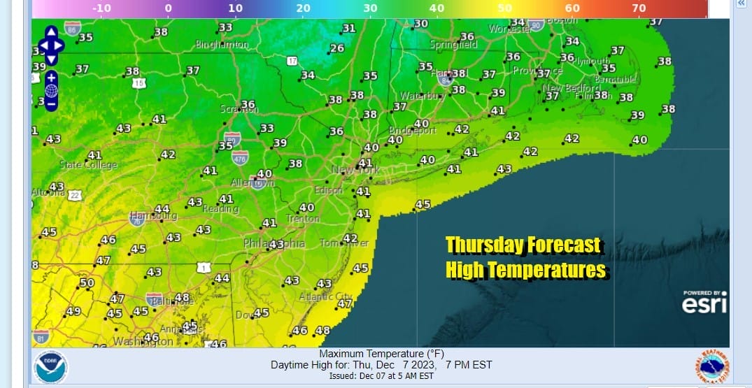
We are still dealing with a series of upper troughs moving southeastward in the northwest flow aloft. This has put us into some cold air for today and satellite and radars show clouds and an area of light snow moving southeastward. This area should slowly dry up and weaken as we move through the day but there is enough there for some folks in Eastern Pennsylvania to Southern New England to see some snow showers or even a brief period of light snow before this all plays out. Otherwise sky conditions will range from cloudy to partly sunny and high temperatures will be in the upper 30s and lower 40s.
SATELLITE WITH LIGHTNING STRIKES

WEATHER RADAR

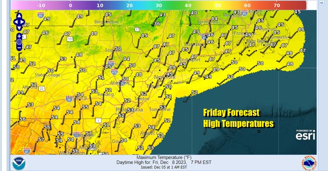
Once the last upper trough pulls out tonight, warmer air will begin to move northeastward and we will see skies partially clear tonight. Lows will be in the mid to upper 20s inland and low to mid 30s in warmer urban centers as well as along the coast. Friday we will warm up nicely with sunshine taking highs to the upper 40s to middle 50s.
As far as the weekend is concerned there is no doubt that Saturday will be the better of two weekend days as we will have the offshore high sending warm air on southwest winds. Saturday should be a day of sunshine and highs will reach the mid to upper 50s in many locations.

Now we move on to Sunday where we will start the day dry and possibly even with some sun. Winds from the south will be increasing as the day wears on and we will probably see sky conditions go from partly sunny to overcast rather quickly. Highs Sunday will be reaching into the 60s just about everywhere except for areas with south and east facing shorelines. Here temperatures will likely be in the 50s.

Low pressure from the southern Plains will head to the Great Lakes with a trailing cold front. There is a strong upper trough driving this front eastward and we will see rain for many areas along and east of the Mississippi River eastward to the East Coast and that likely includes severe weather in parts of the Deep South as well as some welcomed heavy rains in drought plagued areas. This front will push east as another wave develops on it during Sunday.

Weather conditions will deteriorate during the day Sunday as rain develops and becomes heavy at times Sunday night. We are looking at 1 to 2 inches of rain from this in about a 6 to 8 hour window. Winds will be strong and gusty with the pressure gradient tightening. Models have backed off from extremes of the last 2 days but are still showing the potential for gusts to 50 mph especially along coastal locations. Colder air could turn the rain to snow in Northeast Pennsylvania to the Catskills and points northward Sunday night into Monday morning and there will likely be accumulating snows in these regions on the order of at least a few inches. Much of this should be overwith by Monday morning with breezy and colder conditions Monday and highs in the 40s. Once we are done with this weather system it is likely that all of next week will be dry and mostly uneventful with no storms and no weather fronts to deal with.
BE SURE TO DOWNLOAD THE FREE METEOROLOGIST JOE CIOFFI WEATHER APP &
ANGRY BEN’S FREE WEATHER APP “THE ANGRY WEATHERMAN!
MANY THANKS TO TROPICAL TIDBITS FOR THE USE OF MAPS
Please note that with regards to any severe weather, tropical storms, or hurricanes, should a storm be threatening, please consult your local National Weather Service office or your local government officials about what action you should be taking to protect life and property.
(Amazon is an affilate of Meteorologist Joe Cioffi & earns commissions on sales.)


