Snow Shower Chance Late Sunday,
Chance Snow Inland Late Tuesday Rain & Snow Coast

Weather in 5/Joe & Joe Weather Show Latest Podcast
Snow Shower Chance Late Sunday,
Chance Snow Inland Late Tuesday Rain & Snow Coast

Our cold winter day comes to an end and now we have another cold night ahead of us but temperatures tonight should not be as low as the last 2 nights. The core of the cold air has moved out to the east. Skies are clear at least for now this evening. There are high clouds to the west as another cold front approaches. Tonight should start clear but some clouds roll in later. That should keep temperatures from falling. Lows will be mostly in the teens to near 20 in warmer urban areas.
SATELLITE

WEATHER RADAR

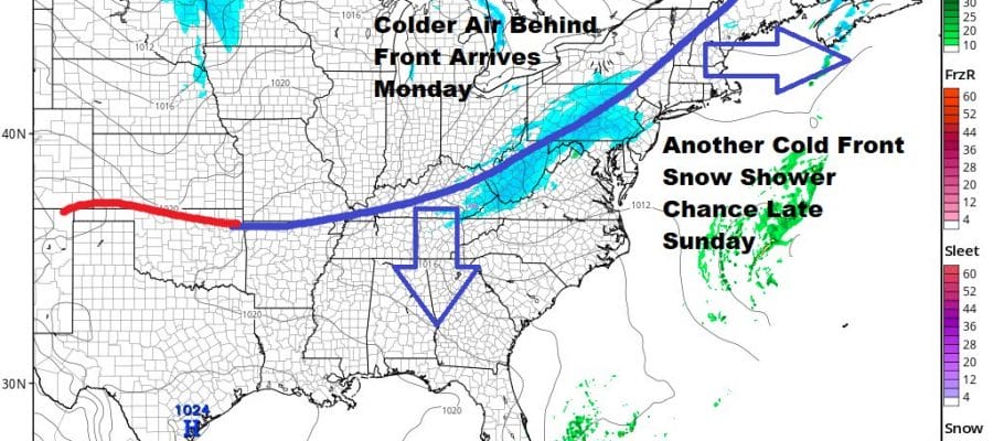
Sunday ahead of this front would be a day where with sunshine, temperatures would run through the 30s to near 40 but we think that we will have clouds around and that will hold temperatures down. The relatively cold start should probably cap highs in the low 30s but colder areas north and west of Philadelphia and NYC might only make it to the upper 20s and lower 30s.

Some models like the NAM for example hold the snow together in Pennsylvania and then it falls apart. The HRRR holds it all together and moves it east Sunday evening. I think the best way to handle this is put in the chance for some snow showers tomorrow late in the day or evening. Maybe some places get the ground whitened but that should be the limit of any snowfall. Usually in cases like this where there isn’t a lot of upper air support, snow tends to dry up trying to cross the mountains of Pennsylvania. We will see how it looks in the morning and reassess the situation. The front pushes offshore and another shot of cold air comes in for Monday. The air behind the front is only a little colder than the air ahead of it. Highs Monday with some sunshine will be in the upper 20s to near 30 in most places.

A similar issue holds for Tuesday as yet another cold front approaches. This one has a little bit of gulf moisture moving up the coast. All the global models have little or nothing with this other than a couple of rain or snow showers. The NAM model this afternoon decided to go a little more aggressive and brings some of that gulf moisture northward from a low off the North Carolina coast. Here again I’m going to throw in the chance for some snow showers inland and rain or snow showers mixed along the coast for Tuesday night. I’m not going to much beyond the chance idea for now and here too I will reassess the situation in the morning. Assuming nothing comes of either system once the Tuesday system goes by, another very cold high builds in and it will be dry but cold through the rest of the week and into next weekend. Whether any other systems follow after Friday is unclear as models remain muddled in the long range.
BE SURE TO DOWNLOAD THE FREE METEOROLOGIST JOE CIOFFI WEATHER APP &
ANGRY BEN’S FREE WEATHER APP “THE ANGRY WEATHERMAN!

MANY THANKS TO TROPICAL TIDBITS & F5 WEATHER FOR THE USE OF MAPS
Please note that with regards to any severe weather, tropical storms, or hurricanes, should a storm be threatening, please consult your local National Weather Service office or your local government officials about what action you should be taking to protect life and property.


