Snow Risks Rise Friday Followed By One Last Shot of Arctic Air

Snow Risks Rise Friday Followed By One Last Shot of Arctic Air
After yesterday’s snow and ice we are now in the arctic air that much of the country has been in since the weekend however it has all be west of the Appalachians. That now has changed though we are seeing a modified version of that Arctic air mass. Today we are looking at sunshine with a few passing clouds. Temperatures today from their bottoms this morning in the teens should make it to the middle and upper 20s. Radars are nice and quiet and we don’t see any issues today.
SATELLITE WITH LIGHTNING STRIKES

WEATHER RADAR

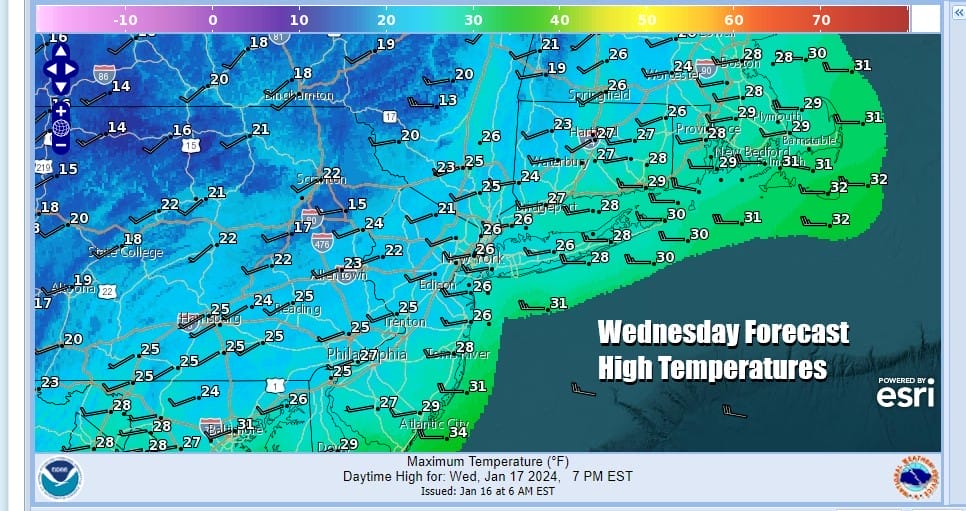
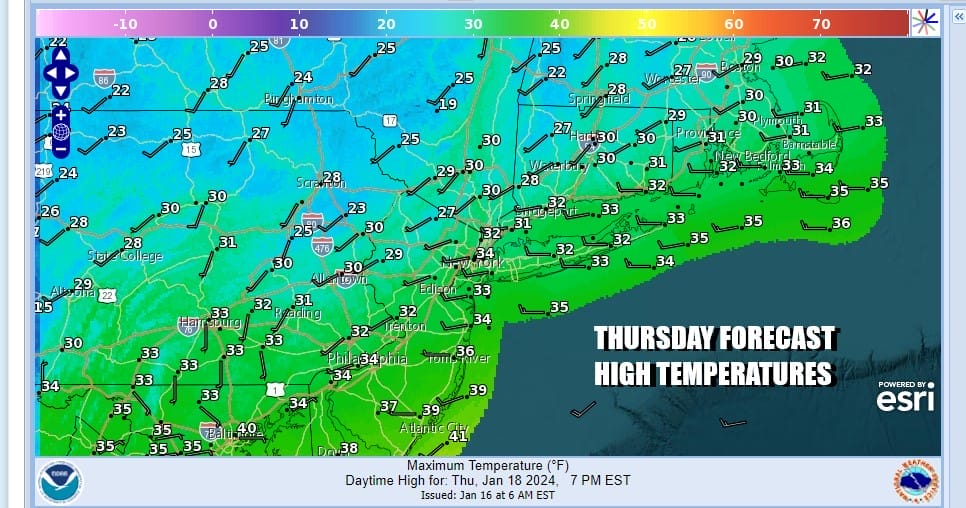
Tonight will be another cold night with lows in the teens to near 20 degrees under mostly clear skies. Thursday is looking like a nice day overall with sunshine and some late day arriving high clouds. Temperatures will moderate a bit more and reach the upper 20s and lower 30s with no snow or rain to worry about.
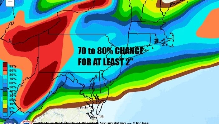
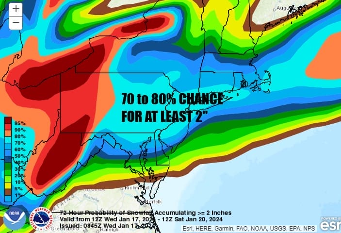
Moving along we have the next storm system to deal with for late Thursday night into Friday evening. Low pressure moves off the North Carolina coast and moves out to the northeast taking significant precipitation with it. However the upper trough behind it will be swinging eastward stretch part of the offshore low back westward. We also will have an northeast wind off the warm ocean interacting with another shot of colder air that will be moving southward.

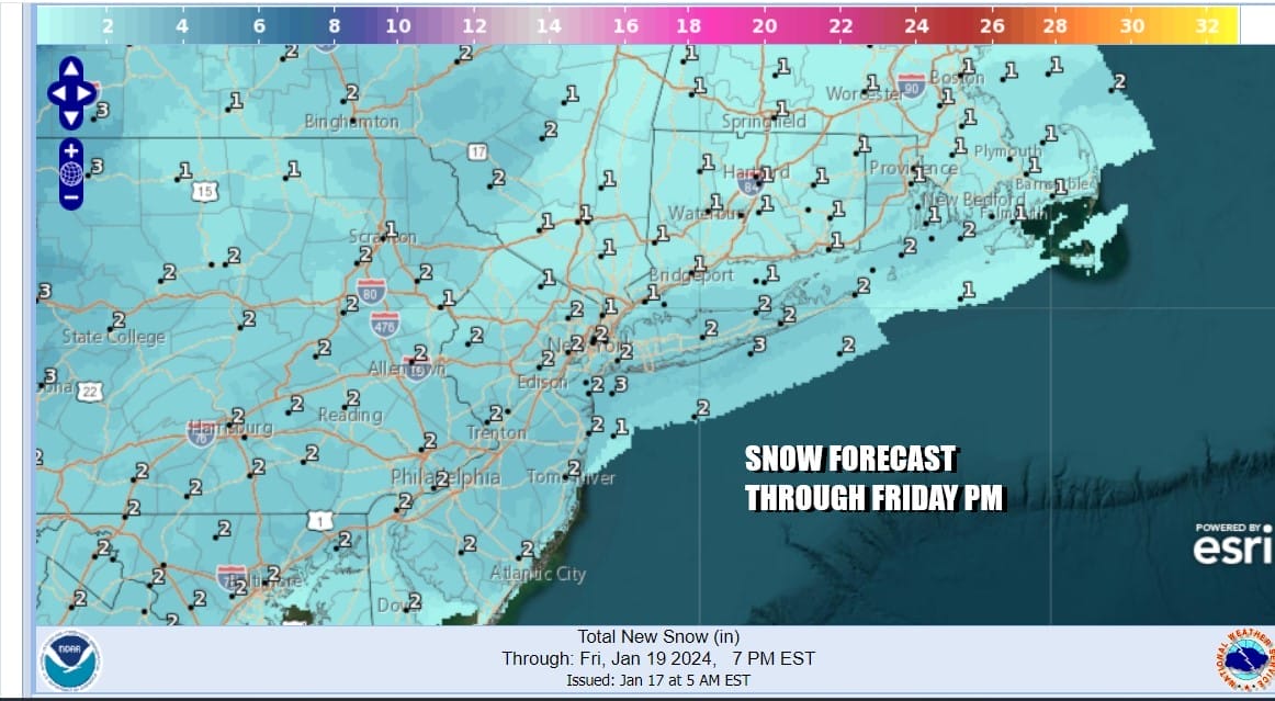
This to me looks like a storm system that would favor areas further south rather than further north. The Weather Prediction Center has set up a high probablitly of 70 to 80 percent chance for at least 2 inches across Southern New England to Pennsylvania southward to Southern New Jersey, to Delaware and Maryland. This includes the big cities from Washington DC to Baltimore to Philadelphia to NYC to Hartford and Providence.
As far as specific snowfall forecast amounts are concerend. the National Weather Service so far has 1 to 2 inches broad brushed over a large area through 7PM Friday and there might be some additional snow for a few hours after 7pm Friday. I expect the numbers to go a little higher and favor higher 2 to 3 inch ore more amounts across Southeast Pennsylvania as well as Central & Southern New Jersey.
What makes forecasting snow amounts a little tricky this time around is the colder environment makes for a more fluffy powdery snow making snow rations more like 12 to 1 or even 14 to one verses the standard 10 to 1. Temperatures will fall into the 20s while snow is falling. Arctic air coming in on the backside of this low offshore and i think we will see lows in the single digits and teens Saturday morning and highs just barely back into the 20s Saturday afternoon with sunshine. Another cold night follows Saturday night and Sunday we will see sunshine and highs back into the 30s.
BE SURE TO DOWNLOAD THE FREE METEOROLOGIST JOE CIOFFI WEATHER APP &
ANGRY BEN’S FREE WEATHER APP “THE ANGRY WEATHERMAN!
MANY THANKS TO TROPICAL TIDBITS FOR THE USE OF MAPS
Please note that with regards to any severe weather, tropical storms, or hurricanes, should a storm be threatening, please consult your local National Weather Service office or your local government officials about what action you should be taking to protect life and property.
(Amazon is an affilate of Meteorologist Joe Cioffi & earns commissions on sales.)


