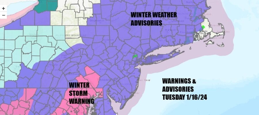
Snow to Freezing Rain Winter Weather Advisories Continue
Very Cold Tonight Wednesday

Snow to Freezing Rain Winter Weather Advisories Continue
Very Cold Tonight Wednesday
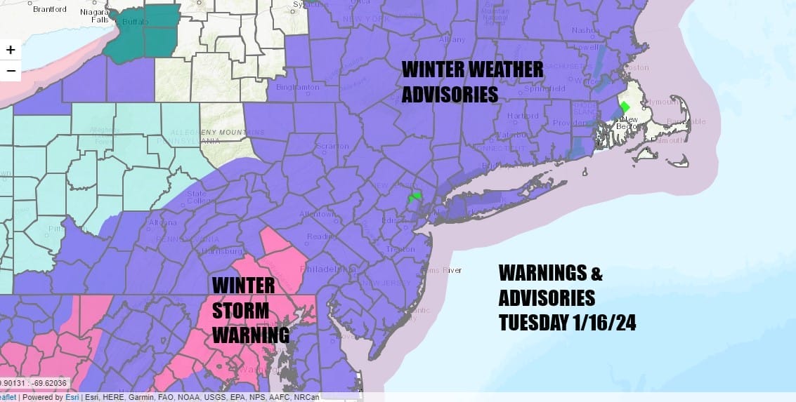
Winter Weather Advisories continue this morning for the Northeast and Mid Atlantic States. We also have Winter Storm Warnings up for counties in South Central Pennsylvania down into Maryland including Wasshington DC and Baltimore. Overnight snow fall is going to continue into this afternoon for areas from Northeast Pennsylvania and Northern New Jersey north and east. It has been a steady light type snow but now we also see warmer air above the surface and changing snow to sleet and freezing rain.
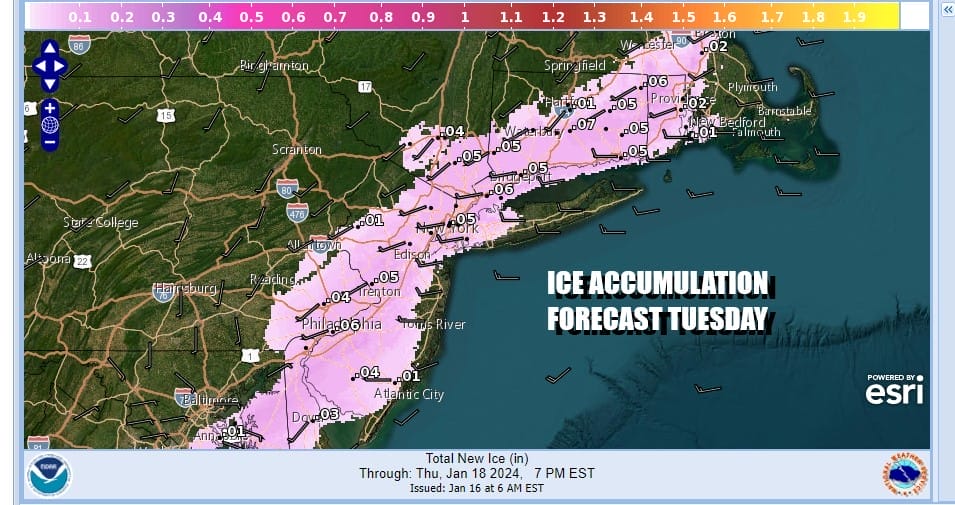
Ice accretion of up to a tenth of an inch is possible across Southern Connecticut and Rhode Island to Long Island (Nassau & Western Suffolk) to NYC, the lower Hudson Valley, south through New Jersey and Southeastern Pennsylvania. Temperatures are going to struggle just to reach 30 to 32 in most areas.

Precipitation will gradually taper off later today and then we see very cold air just to our northwest getting dragged southward. This means everything will ice up this evening and tonight as temperatures drop to the teens everywhere by Wednesday morning. Skies should partially clear overnight. Satellite and radar suggest we still have some work to do as far as preciptiation is concerned so be very cautious if travelling today on all roads.
SATELLITE WITH LIGHTNING STRIKES

WEATHER RADAR

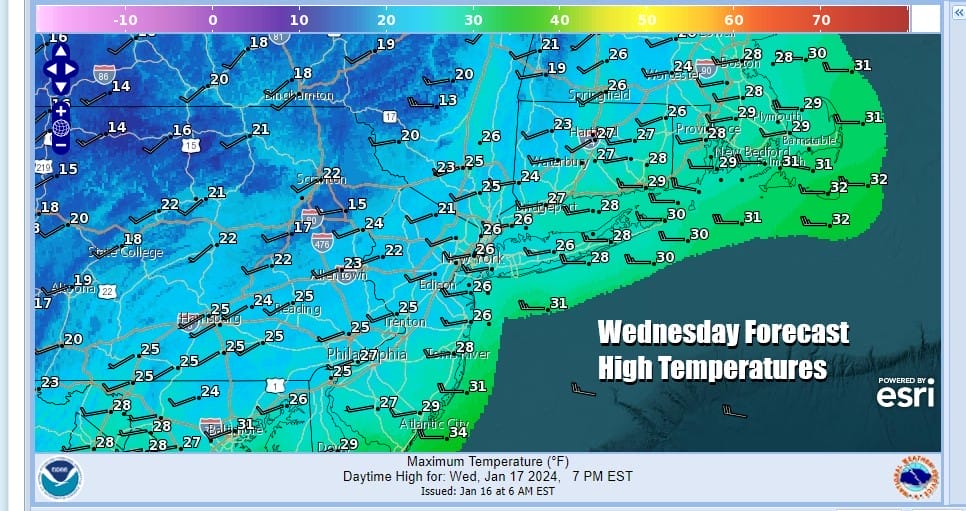
Wednesday is going to be a very cold day as some of the arctic that has been in the Plains, Midwest and South moves in. We see some sunshine mixed with some clouds for Wednesday and high temperatures are likely to struggle only back to the low and middle 20s. This will make it the coldest day of the winter season at least so far.
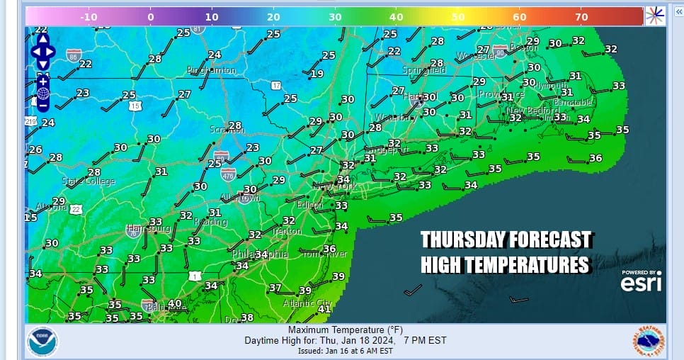
Wednesday night will be another night of lows in the teens to near 20 degrees under mainly clear skies. Temperatures will move higher Thursday with sunshine giving way to some arriving clouds. After the cold start, high temperatures should reach the 30s just about everywhere.
Thursday night into Friday we are going to be watching another area of low pressure moving eastward bringing light snows to the Tennessee and Ohio Valley. The low will reform offshore and move out to the east northeast so we will avoid seeing a bigger snowstorm. However we do see us getting periods of snow Thursday night into Friday night as the low moves out and an upper trough swings southeastward from Eastern Canada.

I think we have the risk of up to a couple of inches of snow from this system I don’t believe at this point that it will be anything more than that. Friday highs will be in the upper 20s and lower 30s. The low will be pulling down progressively clder air as the day wears on so we will see temperatures ease through the 20s in the afternoon and evening. This leads to a very cold Friday night into Saturday morning with lows in the single digits and low teens. Saturday will be a very cold day with sunshine but highs only in the upper teens and lower 20s. The good news is that the cold pulls out beginning Sunday and we will begin a slow warming trend that will carry us through much of next week.
BE SURE TO DOWNLOAD THE FREE METEOROLOGIST JOE CIOFFI WEATHER APP &
ANGRY BEN’S FREE WEATHER APP “THE ANGRY WEATHERMAN!
MANY THANKS TO TROPICAL TIDBITS FOR THE USE OF MAPS
Please note that with regards to any severe weather, tropical storms, or hurricanes, should a storm be threatening, please consult your local National Weather Service office or your local government officials about what action you should be taking to protect life and property.
(Amazon is an affilate of Meteorologist Joe Cioffi & earns commissions on sales.)


