Snow Possible Overnight NYC Northeastward
Snow Possible Overnight NYC Northeastward
This morning we are seeing a cold clear start to the day however the satellite loop shows clouds already racing southeastward from the Great Lakes as a weak frontal boundary sets up just to our south and west. This is going to mean sunshine will eventually give way to arriving clouds. We bottomed out in the teens this morning and temperatures today with a deep snow cover in some areas not getting out of the 20s.
SATELLITE LOOP

REGIONAL RADAR

LOCAL RADAR NEW YORK CITY

LOCAL RADAR PHILADELPHIA


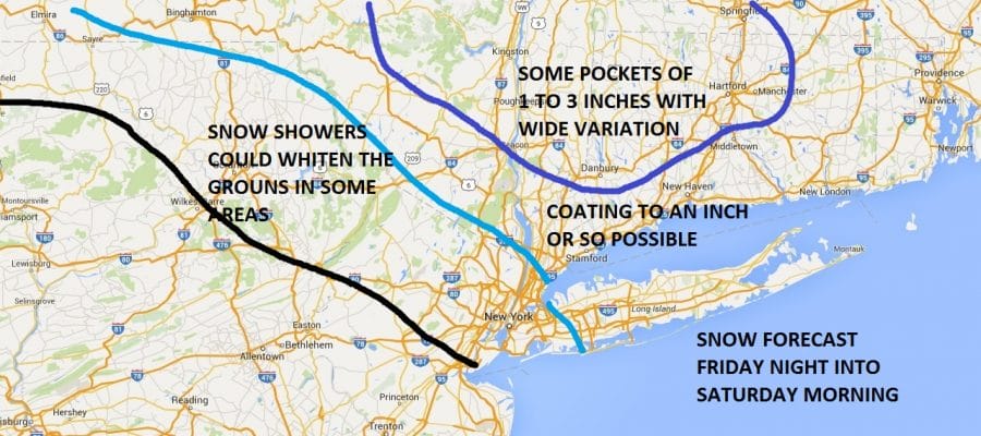
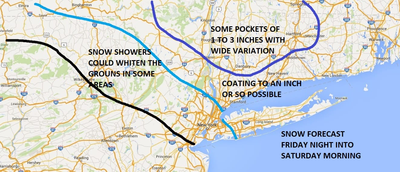
There isn’t anything on the radar at the moment but tonight there will be 2 bursts of snow that will move southeastward. The snow will be blotchy but someone could wind up from a coating to perhaps a few inches as outlined by my snow forecast map
Now once this is done around of shortly after daybreak Saturday we should see lots of clouds and maybe some brightening of skies as temperatures try to head into the 40s.
Sunday offers another system heading our way from the Ohio Valley. This one is going take a track slightly further north than yesterday’s and that sets up a snowstorm for New England. However the southern fringe of the snow with this is not going to be that far away from northern areas. In fact I think that areas in the Hudson Valley near and north of Route 84 and in Connecticut as well could be on the southern edge of several inches with this. A slight southward shift is not impossible given the strong blocking pattern that is setting up in the Atlantic. We will examine this possibility later today as new model runs begin.

SNOW REMOVAL COMPANIES FOR YOUR WINTER NEEDS
LONG ISLAND ROCKLAND COUNTY Connecticut

![]()

ROCKLAND COUNTY TRI STATE SNOW REMOVAL JOHNSTOWN PA


FiOS1 News Weather Forecast For Long Island
FiOS1 News Weather Forecast For New Jersey
FiOS1 News Weather Forecast For Hudson Valley
NATIONAL WEATHER SERVICE SNOW FORECASTS
LATEST JOESTRADAMUS ON THE LONG RANGE
Weather App

Don’t be without Meteorologist Joe Cioffi’s weather app. It is really a meteorologist app because you get my forecasts and my analysis and not some automated computer generated forecast based on the GFS model. This is why your app forecast changes every 6 hours. It is model driven with no human input at all. It gives you an icon, a temperature and no insight whatsoever.
It is a complete weather app to suit your forecast needs. All the weather information you need is right on your phone. Android or I-phone, use it to keep track of all the latest weather information and forecasts. This weather app is also free of advertising so you don’t have to worry about security issues with your device. An accurate forecast and no worries that your device is being compromised.
Use it in conjunction with my website and my facebook and twitter and you have complete weather coverage of all the latest weather and the long range outlook. The website has been redone and upgraded. Its easy to use and everything is archived so you can see how well Joe does or doesn’t do when it comes to forecasts and outlooks.
Just click on the google play button or the apple store button on the sidebar for my app which is on My Weather Concierge. Download the app for free. Subscribe to my forecasts on an ad free environment for just 99 cents a month.
Get my forecasts in the palm of your hand for less than the cost of a cup of Joe!


