SNOW TONIGHT INTO MONDAY MORNING NO CHANGES IN FORECASTS
Snow Overnight Into Monday No Forecast Changes
We see the radar very active going into this evening especially across the Midwest. Snow has been falling all day there and some areas in Northwestern Illinois have gotten over 1/2 a foot with more coming down. Even the NAM model which has been the most aggressive of all the models, underforecasted by 50%. In other words reality doubled the forecast. Now the question is how this all holds together as it translates eastward. There is no reason at this point to go above what most models are indicating though I would be cautious in case something stupid happens overnight and the precipitation area winds up being more robust than forecast.


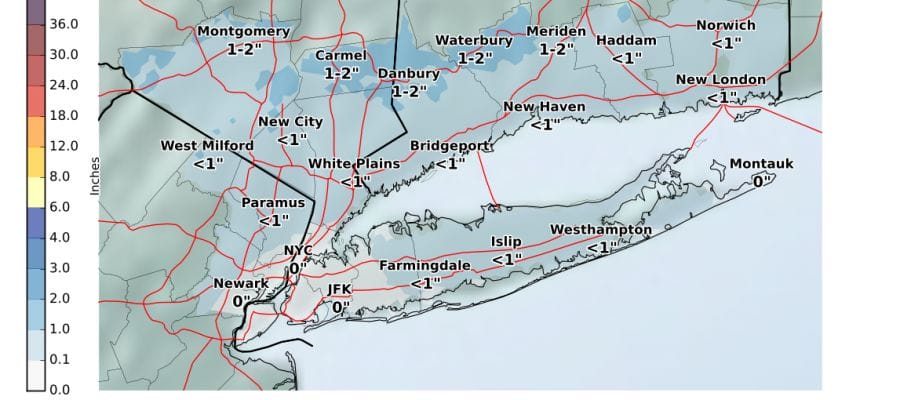
The maps below are the National Weather Service forecast snow maps with the most likely snowfall prediction. Most areas are shown to be a coating to less than an inch. There are pockets of 1 to 2 inches in elevated areas of Northwest New Jersey as well as the Hudson Valley and the hills of Connecticut along and north of Route 84. These are amounts forecast into early Monday afternoon.


There are no changes in the timing of precipitation with wet snow or a mix arriving during the early morning hours and done by 8 or 9 am in most places…perhaps a little later in eastern areas like the Hudson Valley and Connecticut. Weather conditions improve during Monday with some afternoon breaks of sun and highs in the 40s to near 50. Then we get set for the next round of precipitation on Tuesday.
SNOW REMOVAL COMPANIES FOR YOUR WINTER NEEDS
LONG ISLAND ROCKLAND COUNTY Connecticut

![]()

FiOS1 News Weather Forecast For Long Island
FiOS1 News Weather Forecast For New Jersey
FiOS1 News Weather Forecast For Hudson Valley
NATIONAL WEATHER SERVICE SNOW FORECASTS
LATEST JOESTRADAMUS ON THE LONG RANGE
Weather App

Don’t be without Meteorologist Joe Cioffi’s weather app. It is really a meteorologist app because you get my forecasts and my analysis and not some automated computer generated forecast based on the GFS model. This is why your app forecast changes every 6 hours. It is model driven with no human input at all. It gives you an icon, a temperature and no insight whatsoever.
It is a complete weather app to suit your forecast needs. All the weather information you need is right on your phone. Android or I-phone, use it to keep track of all the latest weather information and forecasts. This weather app is also free of advertising so you don’t have to worry about security issues with your device. An accurate forecast and no worries that your device is being compromised.
Use it in conjunction with my website and my facebook and twitter and you have complete weather coverage of all the latest weather and the long range outlook. The website has been redone and upgraded. Its easy to use and everything is archived so you can see how well Joe does or doesn’t do when it comes to forecasts and outlooks.
Just click on the google play button or the apple store button on the sidebar for my app which is on My Weather Concierge. Download the app for free. Subscribe to my forecasts on an ad free environment for just 99 cents a month.
Get my forecasts in the palm of your hand for less than the cost of a cup of Joe!


