Snow Moves Away This Morning Then It is Dry Chilly Remainder of the Week
Rain Arrives Sunday

Snow Moves Away This Morning Then It is Dry Chilly Remainder of the Week
Rain Arrives Sunday

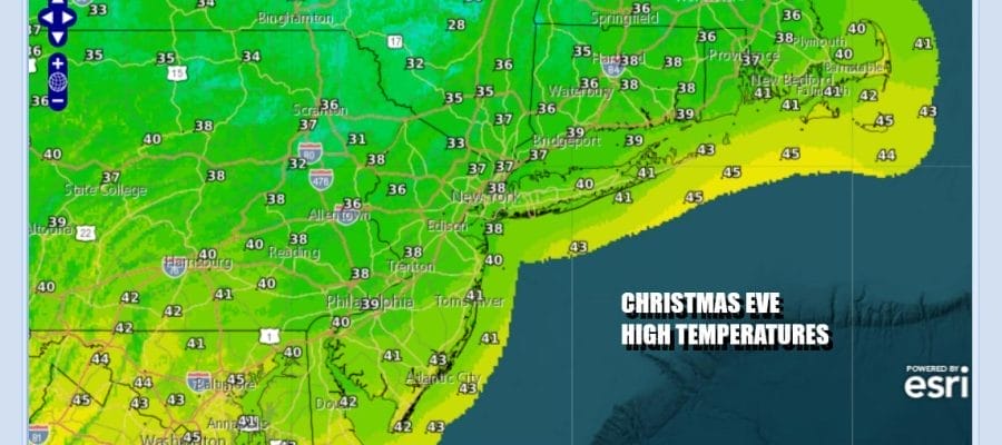
Everything is moving along this morning from west to east. A weather front is passing through and the area of snow with the front will move offshore mid to late morning. A fresh coasting to an inch or so will do it. Then we will see improving weather conditions for this afternoon and some sunshine is likely to develop. Temperatures today will be mostly in the 30s.
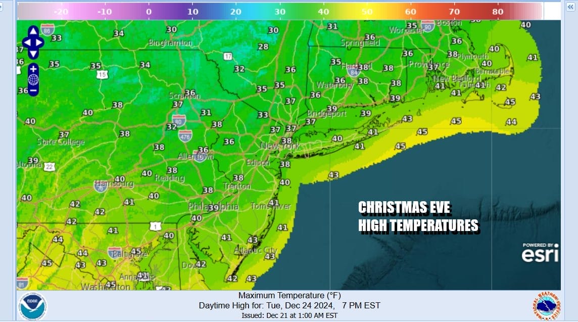
As we move into tonight we will see skies go mostly clear. There are no weather issues for anyone traveling tonight to holiday services. We wish everyone a wonderful, happy, and safe holiday. Most lows tonight will be in the chilly 20s with some teens likely in colder areas north and northwest of the coast and urban centers.
SATELLITE WITH LIGHTNING STRIKES

WEATHER RADAR

Wednesday, Christmas Day will be a nice sunny day. The air behind this front is seasonably cold and not anything extreme like what we just experienced. We expect lots of sunshine for Christmas Day. Most highs will be in the mid to upper 30s. Warmest spots in South Jersey will be close to 40 degrees. Radars will be nice and quiet all day long.

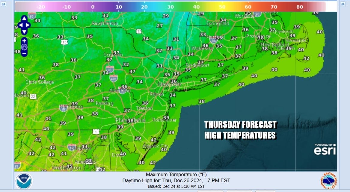
There are no weather issues for the rest of the week as high pressure builds across Upstate NY and New England and that will keep temperatures close to average for this time of year. Both Thursday and Friday will be mainly sunny days. High temperatures both days will be in the mid to upper 30s with nighttime lows mostly in the 20s.
Two storm systems are in play for the remainder of 2024. Low pressure in the Northern Plains runs into Canada this weekend with a trailing weather front. Saturday should be dry with a developing onshore flow so look for any sun to give way to arriving clouds. Rain should stay to the west Saturday. Clouds and some patchy light rain is possible Sunday as the front pushes closer to the coast. Temperatures will likely warm into the 40s for highs over the weekend.

We will likely see a steadier rain coming in for Monday though it doesn’t look to be anything heavy. Then a stronger low heads to the Great Lakes New Year’s Eve and that will bring a steadier heavier rain for late New Year’s Eve into the early part of New Year’s Day. Then we will see the ball begin to roll regarding another change in the overall weather pattern to start 2025.
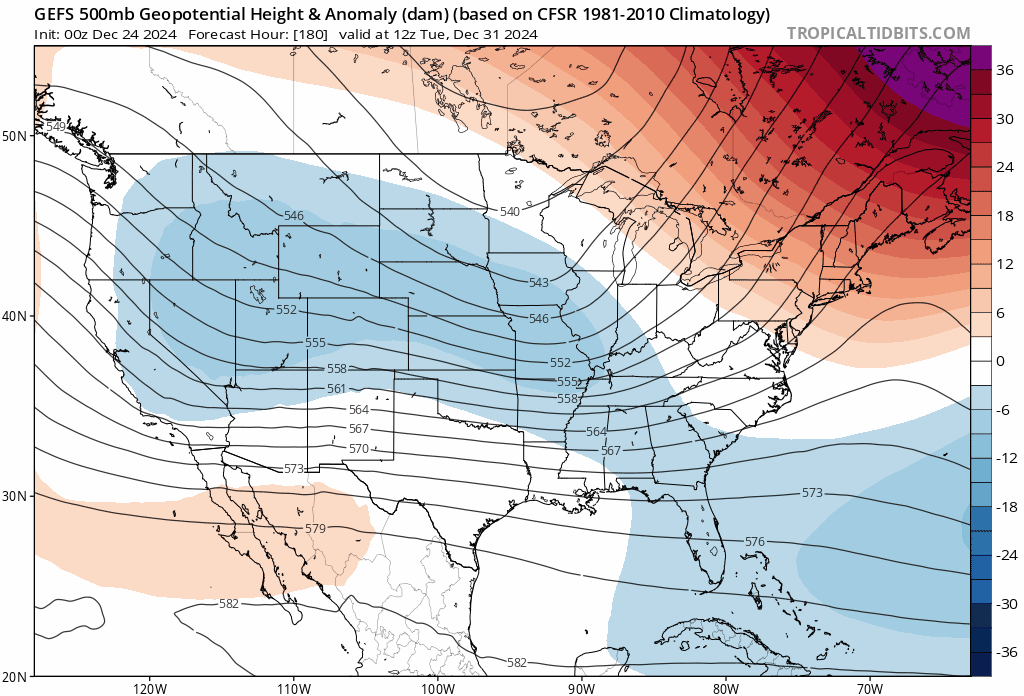
The overall jet stream pattern will change to one which is going to produced sustained cold across much of the Central and Eastern US. We will have a “split flow” scheme with colder air being displaced south from Canada while the southern part of the split will likely produce weather systems moving along from west to east into that colder air. This set up is more favorable for sustained cold as well as for chances for snow along the way. It looks like this colder weather pattern will be hanging around for at least the first half of the month of January. When those snow chances show up is anyone’s guess but for the Eastern US, the period of Januray 4-5th looks to be a possibility.
BE SURE TO DOWNLOAD THE FREE METEOROLOGIST JOE CIOFFI WEATHER APP &
ANGRY BEN’S FREE WEATHER APP “THE ANGRY WEATHERMAN!
MANY THANKS TO TROPICAL TIDBITS FOR THE USE OF MAPS
Please note that with regards to any severe weather, tropical storms, or hurricanes, should a storm be threatening, please consult your local National Weather Service office or your local government officials about what action you should be taking to protect life and property.


