
Merry Christmas A Sunny Chilly Day Dry Weather into the Weekend

Merry Christmas A Sunny Chilly Day Dry Weather into the Weekend
It’s Christmas Day and my hope is that everyone enjoys a wonderful holiday with family and friends. It is a cold Christmas Day which will feature plenty of sunshine, a few passing clouds, seasonal temperatures and no weather related travel issues if you are headed out or family is heading to you. Temperatures this afternoon will be in the 30s to near 40. Tonight will be nice and clear with lows in the 20s except for teens in cold spots. Radars are nice and quiet and will remain so into the weekend.
SATELLITE WITH LIGHTNING STRIKES

WEATHER RADAR

The next several days will feature a cold dome of high pressure over New England that has built southward along the East Coast. It won’t move much over the next several days which will keep weather conditions dry through at least Saturday. It will also be on the chilly side thanks to northerly winds but the air mass is not especially cold so it will keep temperatures close to average for this time of year.

Over the weekend the first of 2 storm systems will approach. The first one is a low that tracks from the Southern Plains to the Great Lakes leaving a cold front that will be pushing east. It seems that any rain from this could hold off until Sunday night lasting into Monday. Then a second low fires up in the Northern Plains and tracks east to the Great Lakes. This will bring some rain during late New Year’s eve into New Year’s Day.
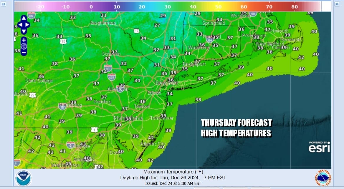
Backing up to Thursday we should see plenty of sunshine with chilly temperatures topping out mostly in the 30s. Nighttime lows both Wednesday night and Thursday night will be generally in the upper teens to lower 20s. Friday also looks to be a day of sunshine with most highs once again in the 30s.

The weekend will warm up as the flow becomes more onshore. We are thinking that Saturday may be no worse than partly sunny, though we need to see if clouds start to develop with the onshore winds. Saturday highs will be in the 40s. Sunday probably has more clouds but we are going to leave rain out of the forecast at least during the dayside. Temperatures will warm further into the 50s. Colder air will wait to return after the system for New Year’s Eve and New Year’s Day. A colder weather pattern will take hold in the longer range.
BE SURE TO DOWNLOAD THE FREE METEOROLOGIST JOE CIOFFI WEATHER APP &
ANGRY BEN’S FREE WEATHER APP “THE ANGRY WEATHERMAN!
MANY THANKS TO TROPICAL TIDBITS FOR THE USE OF MAPS
Please note that with regards to any severe weather, tropical storms, or hurricanes, should a storm be threatening, please consult your local National Weather Service office or your local government officials about what action you should be taking to protect life and property.


