
Snow Makes An Early Appearance

Snow Makes An Early Appearance
Freeze Watch New Jersey Wednesday Morning
Cold Into Thursday
We have a rather unusual setup for late October and it is even more unusual considering the fact that it was just several short days ago that we saw temperatures in the low to mid 80s. But yes there actually is a chance we could see some wet snow and sleet in areas northwest of the coast arriving during the early morning hours on Thursday. I think the best chances of snow and sleet at the start (where you basically see it fall and thats it) will be in areas in Northern New Jersey north and west of 287 and north of route 80..in the Hudson Valley north of rt 287..and in Western Connecticut north of route 15. It will be enough to remind you that winter isn’t that far away. Areas north and west of route 84 may have enough to whiten up the ground especially where elevation is involved. Areas further north in the Catskills and northward up toward Albany might actually see a coating to a couple of inches out of this.
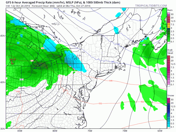
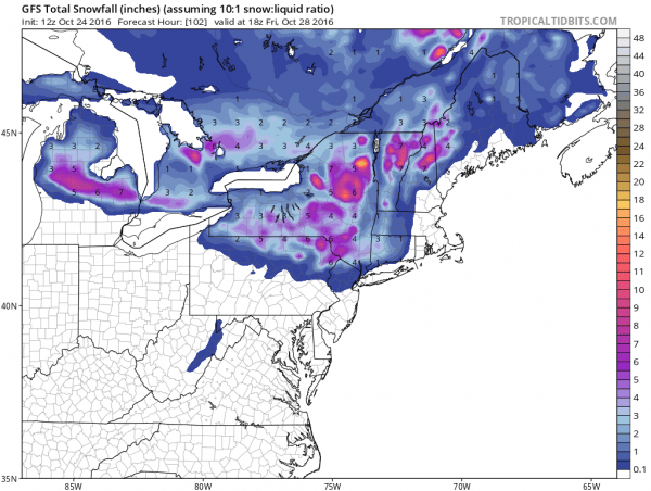
The GFS model is the coldest of all the models today and probably overdoes it a bit particularly when it comes to amounts. It would suggest 2 to 3 inches of wet snow in areas pretty far to the south.
The European model is colder than the overnight but still warmer than the GFS and so is the NAM. The key will be how fast precipitation gets here. If it races east across Pennsylvania and moves in before daybreak there could be a couple of hours of wet snow and sleet in the mix. Even at the coast the air may cold enough to support some ice pellets at the very start. In the meantime it is going to be chilly the next 2 days with a FREEZE WATCH posted for Wednesday morning for much of New Jersey and it will probably be issued for the Hudson Valley and parts of Long Island shortly.
MANY THANKS TO TROPICAL TIDBITS FOR THE WONDERFUL USE OF THE MAPS
SNOW REMOVAL COMPANIES FOR YOUR WINTER NEEDS
LONG ISLAND ROCKLAND COUNTY Connecticut

![]()


WINTER 2016-2017 PART 1 OCEAN WATER TEMPERATURES
WINTER 2016-2017 PART 2 ARCTIC SEA ICE AND SIBERIAN SNOW COVER
FiOS1 News Weather Forecast For Long Island
FiOS1 News Weather Forecast For New Jersey
FiOS1 News Weather Forecast For Hudson Valley
NATIONAL WEATHER SERVICE SNOW FORECASTS
LATEST JOESTRADAMUS ON THE LONG RANGE
Weather App

Don’t be without Meteorologist Joe Cioffi’s weather app. It is really a meteorologist app because you get my forecasts and my analysis and not some automated computer generated forecast based on the GFS model. This is why your app forecast changes every 6 hours. It is model driven with no human input at all. It gives you an icon, a temperature and no insight whatsoever.
It is a complete weather app to suit your forecast needs. All the weather information you need is right on your phone. Android or I-phone, use it to keep track of all the latest weather information and forecasts. This weather app is also free of advertising so you don’t have to worry about security issues with your device. An accurate forecast and no worries that your device is being compromised.
Use it in conjunction with my website and my facebook and twitter and you have complete weather coverage of all the latest weather and the long range outlook. The website has been redone and upgraded. Its easy to use and everything is archived so you can see how well Joe does or doesn’t do when it comes to forecasts and outlooks.
Just click on the google play button or the apple store button on the sidebar for my app which is on My Weather Concierge. Download the app for free. Subscribe to my forecasts on an ad free environment for just 99 cents a month.
Get my forecasts in the palm of your hand for less than the cost of a cup of Joe!
![]()


