Snow From Time to Time Into Saturday Morning
A Coating to An Inch or Two Ahead of Arctic Cold

Snow From Time to Time Into Saturday Monring
A Coating to An Inch or Two Ahead of Arctic Cold

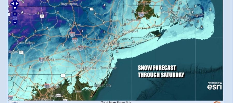
We have arrived at the doorstep of the weekend and we have some snow in the forecast. In general for Eastern Pennsylvania to Southern New England, including New Jersey, NYC, the Hudson Valley, Long Island and much Connecticut, it is going to be a light event. Clouds are increasing and look for precipitation developing this afternoon. Along the coast we will see a little rain or a mix at the start. Inland some snow will develop. You can expect the precipitation to be light and patchy as we have two weather systems in play. One is a strong upper trough coming in from the west. The other is a coastal low developing off the Virginia coast.
SATELLITE WITH LIGHTNING STRIKES

WEATHER RADAR

Given that the two systems never really phase together, we will not see a widespread swath of precipitation. Instead it willl be rather patchy in nature into Saturday morning. At times it will be precipitating in one place and not the other. The coastal low grazes the coast with heavy precipitation offshore. The upper trough then comes into play tonight and Saturday morning along with colder air on northerly winds.

Precipitation will continue on and off into Saturday morning before ending by midday in most areas. Snow accumulations will be on the light side. A general coating to an inch is likely. Some colder elevated areas could wind up with an inch or two. Since the two systems stay separate, it is hard to imagine there being much in the way of upside though I’m sure someone may wind up getting a minor jackpot amount.
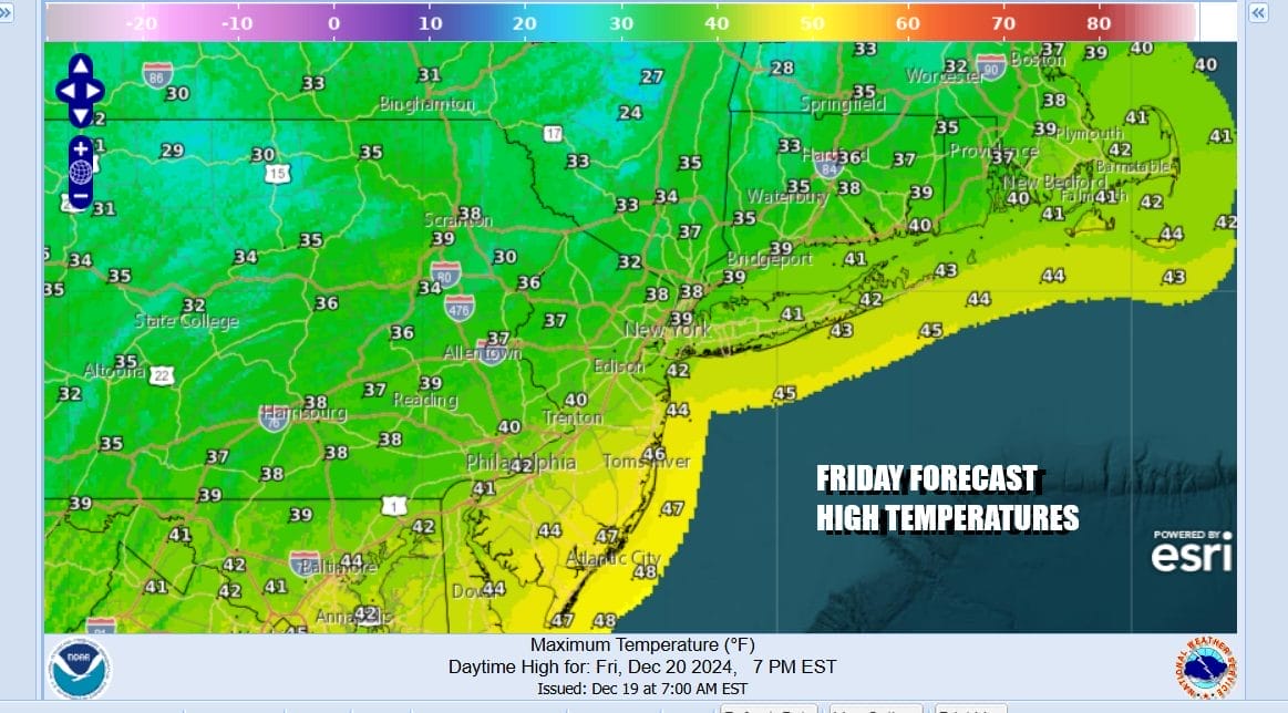
Most high temperatures today will be in the mid 30s to lower 40s with the warmer temps in South Jersey and points south while areas from Northern New Jersey north and east will be in the 30s all day. Then tonight as colder air starts to filter southward, it should turn any precipitation along the coast to snow while inland the on and off light snow continues. Lows tonight will be in the upper 20s and lower 30s. Temperatures Saturday will hold in the upper 20s and lower 30s all day as northerly winds increase.

Cold arctic air will be coming in Saturday night and that will send temperatures down to the teens everywhere and some single digits to the north in the Hudson Valley and Connecticut. Sunday will be a sunny but very cold day as northerly winds continue. High temperatures will only be in the low and middle 20s making it the coldest weather day in over a year.

Sunday night into Monday morning it will be the coldest night of the winter season so far as temperatures drop to the low teens and single digits across the entire area. Monday we will begin to moderate slightly with sunshine taking highs to the upper 20s and lower 30s. The cold weather pattern pulls out slowly next week as temperatures warm up some going into Christmas Eve into Christmas Day. We could see another light precipitation event going into the Christmas holiday.
BE SURE TO DOWNLOAD THE FREE METEOROLOGIST JOE CIOFFI WEATHER APP &
ANGRY BEN’S FREE WEATHER APP “THE ANGRY WEATHERMAN!
MANY THANKS TO TROPICAL TIDBITS FOR THE USE OF MAPS
Please note that with regards to any severe weather, tropical storms, or hurricanes, should a storm be threatening, please consult your local National Weather Service office or your local government officials about what action you should be taking to protect life and property.


