Arctic Air Takes Over Into Monday
Teens & Single Digit Temperatures Next 2 Nights

Arctic Air Takes Over Into Monday
Teens & Single Digit Temperatures Next 2 Nights

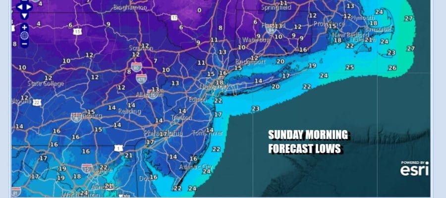
We are going to see the overnight snows pass off to the east and then it is on to arctic air. Most areas in Eastern Pennsylvania finished up with a coating to an inch or two. Northerly winds flowing south from Northeastern Canada is typically how the Northeast and Northern Mid Atlantic states very cold air. Clouds will give way to some sunshine today along with a gusty wind and temperatures that will hold in the upper 20s and lower 30s all day. Then it is on to very cold and breezy conditions overnight under clear skies. By Sunday morning temperatures will bottom in the single digits and teens. Wind chills will make it feel like it is sub zero.
SATELLITE WITH LIGHTNING STRIKES

WEATHER RADAR

We will see radar activity slowly diminish today as the upper trough moves offshore. Lake effect snow showers are going to develop in Upstate NY and the South Shore of Lake Erie in Ohio along with leftover snow in New New England. This diminishes further Sunday. Temperatures across Eastern Pennsylvania to Southern New England will be in the low to mid 20s for highs Sunday.

Skies will be mostly clear Sunday night as high pressure begins to push into NY State and winds begin to drop off. It will another very cold night indeed and most lows Monday morning will be in the single digits inland while most areas along the coast and warmer urban locations will bottom between 10 and 15 degrees.

Monday will be a day of sunshine and some arriving clouds. Temperatures will moderate somewhat as highs will reach the upper 20s and lower 30s. High pressure and arctic air will move out and we have a weak low moving across the Great Lakes Monday night into Tuesday. There will likely be an area of snow ahead of weak cold front. Most of that snow will pass to the north in Upstate NY and New England Monday night into Tuesday morning.

Cold air is done for now after this current air mass moves out and we will see warmer temperatures Tuesday Christmas Eve and Christmas Day though the warmup will be slow as temperatures get back to normal. Tuesday highs with clouds around will be in the upper 30s and lower 40s. Christmas Day will be dry with some sunshine and highs again will be in the upper 30s and lower 40s. We may be storm free and quiet right up to New Year’s Eve where models are signaling the beginning of the next round of pattern changes.
BE SURE TO DOWNLOAD THE FREE METEOROLOGIST JOE CIOFFI WEATHER APP &
ANGRY BEN’S FREE WEATHER APP “THE ANGRY WEATHERMAN!
MANY THANKS TO TROPICAL TIDBITS FOR THE USE OF MAPS
Please note that with regards to any severe weather, tropical storms, or hurricanes, should a storm be threatening, please consult your local National Weather Service office or your local government officials about what action you should be taking to protect life and property.


