
Coldest Night in 2 Years Lows Single Digits & Teens
Chance For Snow Monday Night into Christmas Eve Morning

Coldest Night in 2 Years Lows Single Digits & Teens
Chance For Snow Monday Night into Christmas Eve Morning

It hasn’t been this cold in nearly 2 years across Eastern Pennsylvania to Southern New England. Northerly winds have brought down very cold air that came in behind the Friday storm system. Add a little snow cover to the mix and you have the recipe for a cold day and an even colder night. Any sunshine today will be relatively ineffective as highs only reach 20 to 25 in most areas. A few colder spots might not even see 20.
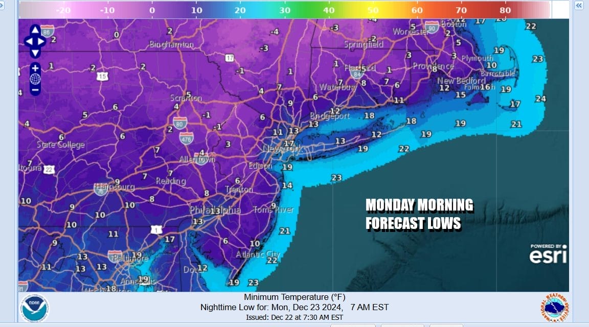
Tonight will be very cold especially away from warmer urban centers that should bottom out mostly in the lower teens. Just inland and way from the coast especially where we have clear skies, light winds, and snow cover, lows Monday morning will be down in the low and middle single digits and some of the coldest spots could see temperatures bottom below zero.
SATELLITE WITH LIGHTNING STRIKES

WEATHER RADAR

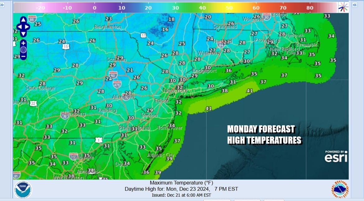
Monday will be another cold day but the core of the coldest air will be moving to the east so temperatures should rebound somewhat from their very low morning levels. Sunshine wills start the day and then we will see arriving clouds as a cold front approaches from the northwest and low pressure moves east across the Great Lakes. Highs will reach the upper 20s and lower 30s.
Monday night into Tuesday morning we have a cold front that will be crossing the area. The air ahead of the front normally would warm up some but there is so much cold air around that any precipitation that develops ahead of the front will be snow showers and this could produce another coating to perhaps an inch late Monday night into early Christmas Eve Morning.

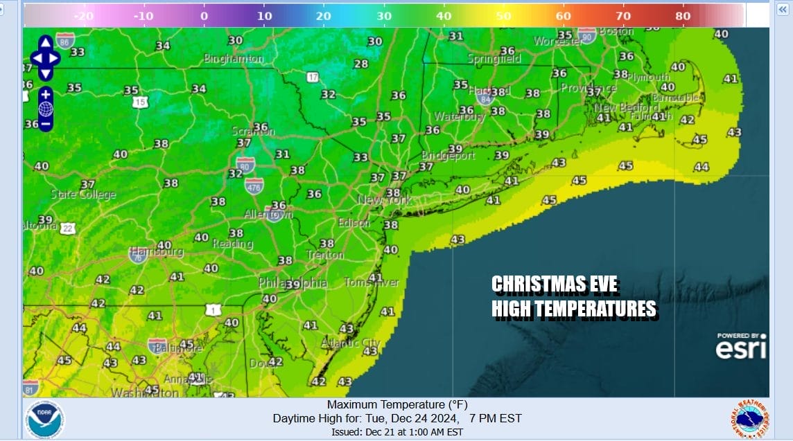
This puts a little touch of extra white for Christmas Eve which will be chilly but temperatures will be back to about where they should be for this time of year. Most highs will be in the mid 30s to around 40 degrees in the warmest spots, and we will see clouds give way to some sunshine. Weather should not cause any travel issues once the early morning snow is over with.
Tuesday night into Christmas morning, skies will be mostly clear with most lows in the low to mid 20s with some teens inland. Christmas Day should see clouds and only limited sunshine as a cold high builds to the north and a weak frontal boundary lies across the Mid Atlantic states. High temperatures will be in the 30s in in most places.There could be a little snow for areas in South Central and Southeast Pennsylvania south into Maryland during the afternoon and early evening on Christmas Day but we do not see this becoming a big issue.

. As we head toward the end of the week, we will continue to see a slow moderation in temperatures but it will indeed be slow. It does appear to be dry with no weather issues through at least Friday and possibly a bit beyond that. No major storms or major cold shots are on the horizon for the last days of 2024.
BE SURE TO DOWNLOAD THE FREE METEOROLOGIST JOE CIOFFI WEATHER APP &
ANGRY BEN’S FREE WEATHER APP “THE ANGRY WEATHERMAN!
MANY THANKS TO TROPICAL TIDBITS FOR THE USE OF MAPS
Please note that with regards to any severe weather, tropical storms, or hurricanes, should a storm be threatening, please consult your local National Weather Service office or your local government officials about what action you should be taking to protect life and property.


