
Snow Friday Night Saturday Weather Model Analysis

Snow Friday Night Saturday Weather Model Analysis
Warm frontal snowfalls are very tricky to forecast. They tend to be a bit more convective in nature which means that you could see some variation in amounts over a given area rather than a blanket even snowfall. Also we are talking about a fast 6 to 8 hour snowfall event. The difference between snowing for 6 hours and snowing for 8 hours could be as much as 2 to 4 inches! Small differences in temperature or wind can make big differences in snow amounts especially along the coast.

One of the things we will be watching is the development of a small wave on the warm front. All the models have this to some degree. The Canadian model for some reason has the best refection of this.
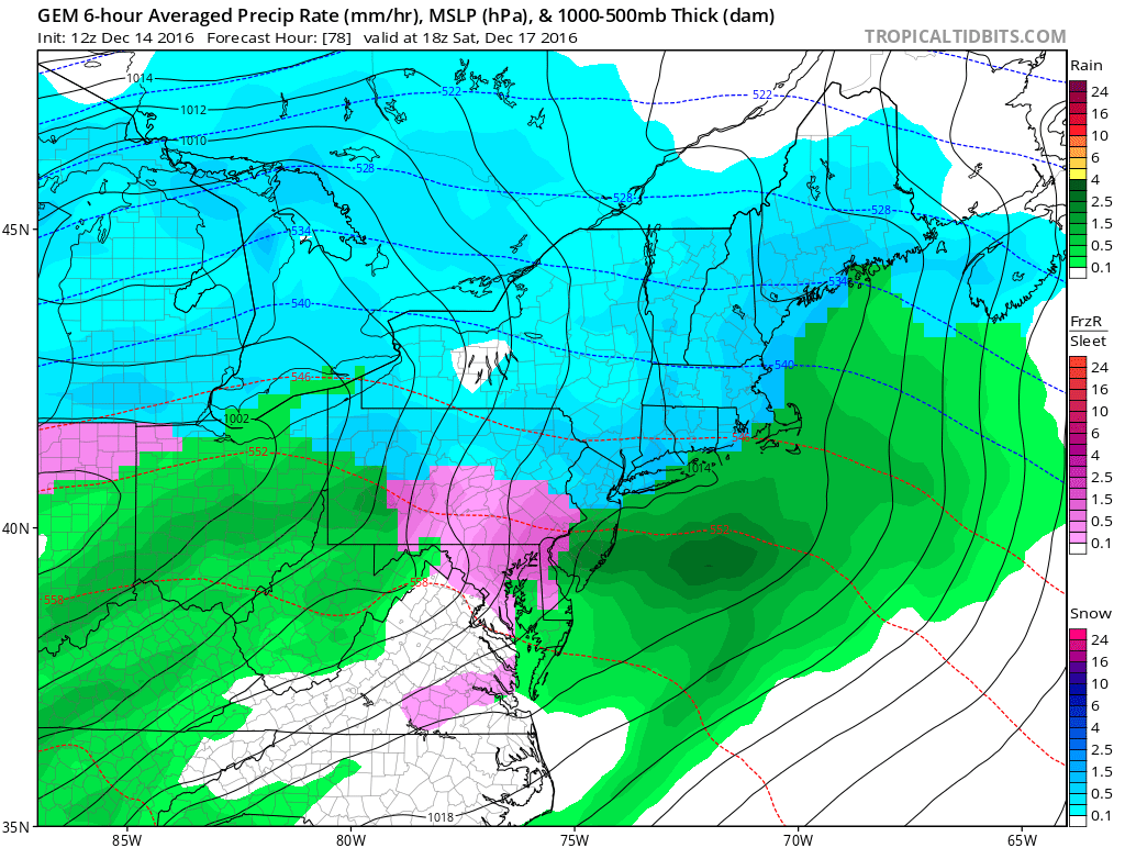
You can see where the isobars (dark thin black lines) bulge a bit out to the east of New Jersey. A wave like this could be something that prolongs the snow for a couple of hours which would make a huge difference in snow amounts for someone. In any event it all goes to rain regardless.

The second question is on Sunday. The cold front comes through Sunday morning with colder air behind it. The GFS and to a lesser extent the European Model try to make another wave on that front which changes the rain back to snow on the backside briefly Sunday evening. Most times the rain just shuts off in cases like this and you get no changeover. We will have to see if that wave is real and if other short term models pick up on that over the next few days. Right now I would favor a quick end to the rain Sunday evening maybe as some sleet or snow with little if any impact except in areas further north and west of the coast.
As far as the specific snowfall forecasts you can check my early call post from this morning as I am planning no changes to this. Below is a video of specific snow forecasts for Friday night and Saturday.
MANY THANKS TO TROPICAL TIDBITS FOR THE WONDERFUL USE OF THE MAPS
SNOW REMOVAL COMPANIES FOR YOUR WINTER NEEDS
LONG ISLAND ROCKLAND COUNTY Connecticut

![]()


JOHNSTOWN PA
COLOSIMO LAWNCARE

FiOS1 News Weather Forecast For Long Island
FiOS1 News Weather Forecast For New Jersey
FiOS1 News Weather Forecast For Hudson Valley
NATIONAL WEATHER SERVICE SNOW FORECASTS
LATEST JOESTRADAMUS ON THE LONG RANGE
Weather App

Don’t be without Meteorologist Joe Cioffi’s weather app. It is really a meteorologist app because you get my forecasts and my analysis and not some automated computer generated forecast based on the GFS model. This is why your app forecast changes every 6 hours. It is model driven with no human input at all. It gives you an icon, a temperature and no insight whatsoever.
It is a complete weather app to suit your forecast needs. All the weather information you need is right on your phone. Android or I-phone, use it to keep track of all the latest weather information and forecasts. This weather app is also free of advertising so you don’t have to worry about security issues with your device. An accurate forecast and no worries that your device is being compromised.
Use it in conjunction with my website and my facebook and twitter and you have complete weather coverage of all the latest weather and the long range outlook. The website has been redone and upgraded. Its easy to use and everything is archived so you can see how well Joe does or doesn’t do when it comes to forecasts and outlooks.
Just click on the google play button or the apple store button on the sidebar for my app which is on My Weather Concierge. Download the app for free. Subscribe to my forecasts on an ad free environment for just 99 cents a month.
Get my forecasts in the palm of your hand for less than the cost of a cup of Joe!
![]()
