Arctic Air Arriving Coating of Snow NJ
Arctic Air Arriving Coating of Snow NJ
We are seeing the beginning of the arrival of cold arctic air which will take temperatures down to the teens and single digits by Friday morning and wind chills down below zero. Today we have plenty of sun to start but some clouds will develop as the arctic front approaches.

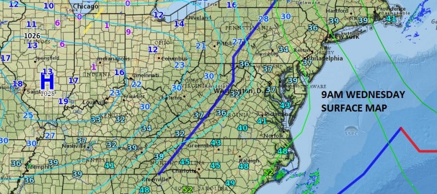
You can see the 9am temperatures in the midwest are in the single digits this morning and that is the air that is headed here beginning Thursday into Friday night. The question is whether there could be a burst of snow when the cold air arrives tonight. Right now radars are quiet and should remain so for awhile today.
Arctic Air Arriving Coating of Snow Radar Loops


I think the best chances for anything snow wise tonight will be in Southern New Jersey south of 195 and particularly the southern counties of Atlantic and Cape May where a coating to an inch of snow could fall. Afterwards the story will be temperatures and some snow showers Thursday that could whiten the ground in spots. Friday morning we will see the coldest temps and conditions with lows in the teens and single digits and wind chills below zero. Highs Thursday and Friday just in the 20s.
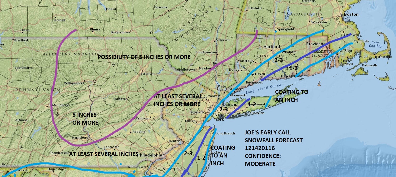
Snow is set to arrive for later Friday night and Saturday before changing to rain. Here is my early call snow forecast map. More on this on JOESTRADAMAS’S latest forecast post.
SNOW REMOVAL COMPANIES FOR YOUR WINTER NEEDS
LONG ISLAND ROCKLAND COUNTY Connecticut

![]()

FiOS1 News Weather Forecast For Long Island
FiOS1 News Weather Forecast For New Jersey
FiOS1 News Weather Forecast For Hudson Valley
NATIONAL WEATHER SERVICE SNOW FORECASTS
LATEST JOESTRADAMUS ON THE LONG RANGE
Weather App

Don’t be without Meteorologist Joe Cioffi’s weather app. It is really a meteorologist app because you get my forecasts and my analysis and not some automated computer generated forecast based on the GFS model. This is why your app forecast changes every 6 hours. It is model driven with no human input at all. It gives you an icon, a temperature and no insight whatsoever.
It is a complete weather app to suit your forecast needs. All the weather information you need is right on your phone. Android or I-phone, use it to keep track of all the latest weather information and forecasts. This weather app is also free of advertising so you don’t have to worry about security issues with your device. An accurate forecast and no worries that your device is being compromised.
Use it in conjunction with my website and my facebook and twitter and you have complete weather coverage of all the latest weather and the long range outlook. The website has been redone and upgraded. Its easy to use and everything is archived so you can see how well Joe does or doesn’t do when it comes to forecasts and outlooks.
Just click on the google play button or the apple store button on the sidebar for my app which is on My Weather Concierge. Download the app for free. Subscribe to my forecasts on an ad free environment for just 99 cents a month.
Get my forecasts in the palm of your hand for less than the cost of a cup of Joe!


