Snow Forecasts Friday 01062017
Snow Forecasts Friday 01062017
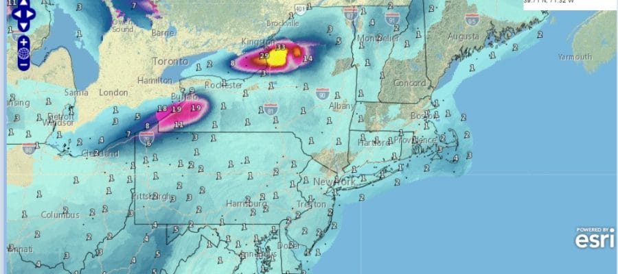
These are the latest updated snow forecast maps from the National Weather Service for the system that is moving through Thursday night into Friday morning. Except for the NAM model which was rather robust overnight, the other models have backed off and show a much weaker system developing offshore Thursday night. These models such as the GFS, Canadian and others would argue for snow amounts of no more than a coating to an inch or 2 at most in some places. We suspect that the weather service forecast maps will reflect this in the morning maps you see here. Later this morning we will of course reevaluate the situation accordingly. With regards to the second system off the Southeast coast Friday night and Saturday, the Canadian model has shifted to the left again and brings snow for a brief time into coastal Southern New Jersey and Eastern Long Island during the day Saturday for a brief time but it doesn’t produce much more than a coating to an inch or 2 in those areas.
NEW YORK CITY AND VICINITY SNOW

NEW YORK CITY & VICINITY ICE

NEW JERSEY & PARTS OF NE PA

SOUTHERN AND SOUTHEAST NEW ENGLAND

NORTHERN NEW ENGLAND

WESTERN NEW ENGLAND

MIDDLE AND UPPER HUDSON VALLEY

CENTRAL NEW YORK & NE PA

WESTERN NEW YORK

CENTRAL & SOUTH CENTRAL PA

VIRGINIA & MARYLAND

DAILY NORTHEAST SNOWFALL

Please be advised that these are National Weather Service Forecast Maps and they auto update. Each office may update at different times and some offices are slower to update then others. Maps are usually updated before 5am and & 5pm however they may be updated at other times depending on forecast conditions. These are not my forecasts. My forecasts can be found on the JOE’S SNOWFORECAST PAGE. Individual forecasts for specific areas may also be found when conditions warrant on the my area forecasts. Those can be found on the website menu. Click on forecasts and then select your specific area.
SNOW REMOVAL COMPANIES FOR YOUR WINTER NEEDS
LONG ISLAND ROCKLAND COUNTY Connecticut

![]()

ROCKLAND COUNTY TRI STATE SNOW REMOVAL JOHNSTOWN PA