Snow Forecast Saturday Into Sunday Morning

Snow Forecast Saturday Into Sunday Morning

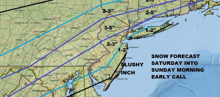
It seems that model trends continue to be a little colder with every run at least so far. The European model this afternoon is the most aggressive of the bunch showing double these amounts but I’m not comfortable for going higher than this at the moment. The high goes out to the east which would argue for low level warm air but the European wraps up a fast moving coastal low and takes it east northeast which cuts off the warm air and allows colder air to the north to drain southward. Given the time of year and climatology is in favor of snow we will lean to the colder look for now. Coastal numbers are skewed lower at the moment until we get a clearly picture of whether cold air becomes more important. Even if we wind up on the high end there may be no need to shovel since warmer air will move next week and melt it all away rather quickly. Longer range models are all pointing to a blocking pattern beginning to develop late next week so the warm up will likely last only several days. Then it will be a grinding process as the upper atmosphere rearranges itself for the last days of February and the beginning of March. We will discuss the long range later on in an extensive JOESTRADAMUS post.
SHOP THE JOESTRADAMUS STORE
MANY THANKS TO TROPICAL TIDBITS FOR THE WONDERFUL USE OF THE MAPS

GET JOE A CIGAR IF YOU LIKE!
FiOS1 News Weather Forecast For Long Island
FiOS1 News Weather Forecast For New Jersey
FiOS1 News Weather Forecast For Hudson Valley
NATIONAL WEATHER SERVICE SNOW FORECASTS
LATEST JOESTRADAMUS ON THE LONG RANGE