
Snow Forecast Saturday 02172018 National Weather Service
SHOP AMAZON VIA JOESTRADAMUS!
Snow Forecast Saturday 02172018 National Weather Service
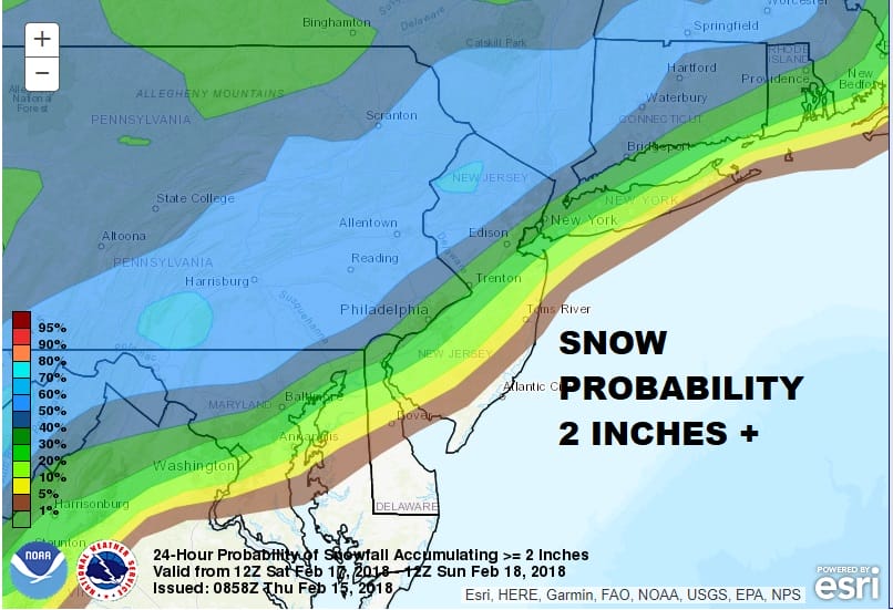
The map above shows the National Weather Service snow forecast for Sunday with the area in blue indicating the highest probability for at least 2 inches. After looking at the overnight weather models it would seem that this system is behaving much like the others have in the past few weeks which would favor snow north and west of the coast or just north and west of I-95. The European and Canadian models overnight have a colder looking system but its hard to argue against a change to rain along the immediate coast since the cold high moves out to the east. The developing low would have to pinch off the cold air in a hurry in order to produce anything substantial in coastal areas. I tend to think the Weather Service’s numbers for Long Island and New York City are a bit on the high side at this point. We would have to see a significantly colder atmosphere in models going forward for me change my line of thinking.

GET JOE A CIGAR SO HE CAN RELAX!
NEW YORK CITY AND VICINITY SNOW

NEW JERSEY & PARTS OF NE PA

SOUTHERN AND SOUTHEAST NEW ENGLAND

NORTHERN NEW ENGLAND

WESTERN NEW ENGLAND

MIDDLE AND UPPER HUDSON VALLEY

CENTRAL NEW YORK & NE PA

WESTERN NEW YORK

CENTRAL & SOUTH CENTRAL PA

VIRGINIA & MARYLAND

DAILY NORTHEAST SNOWFALL

Please be advised that these are National Weather Service Forecast Maps and they auto update. Each office may update at different times and some offices are slower to update then others. Maps are usually updated before 5am and & 5pm however they may be updated at other times depending on forecast conditions. These are not my forecasts. My forecasts can be found on the JOE’S SNOWFORECAST PAGE. Individual forecasts for specific areas may also be found when conditions warrant on the my area forecasts. Those can be found on the website menu. Click on forecasts and then select your specific area.