Snow Forecast First Early Call

Snow Forecast First Early Call

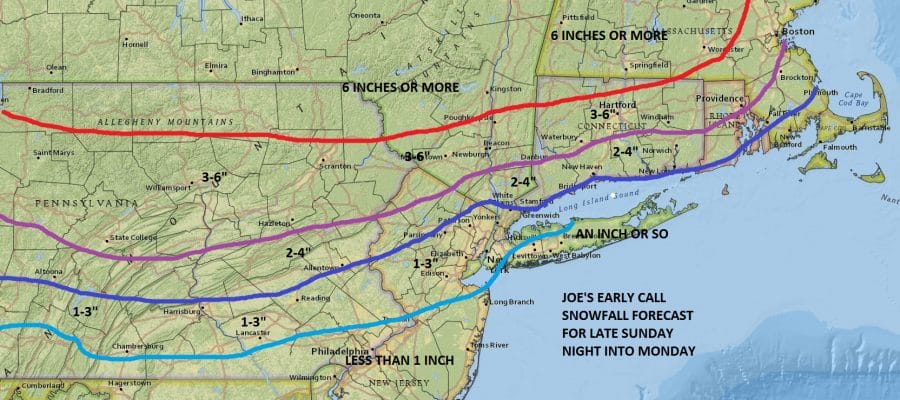
With regards to the snow this is what I see happening
During the day Sunday into Sunday evening there could be patches of light snow in some places. It might be enough to leave a coating and spots or a little bit more. I don’t think this is problematic.
Steady snow develops Sunday night from west to east and reaches the coast during the early morning hours. I am leaning toward the ideal of a flatter looking low coming out of the Ohio Valley and matches up somewhat with the Canadian and European View of this.

The GFS model has what I believe an overdeveloped primary low in the Ohio Valley and I think it will be weaker which means it will be colder longer over much of the immediate Coastal Northeast. My concern for areas inland of the coast such as Northern New Jersey, the Hudson Valley and Interior Connecticut north of Route 15 is that temperatures may have a difficult time climbing above freezing on Monday which cold create a period of sleet/freezing rain. But that is a fine tuned detail that needs to be addressed in the shorter range. All of this should come to an end late Monday or Monday evening. For the coast of Central and Southern New Jersey it should be an inch or less. For Central and Eastern Long Island it is always a tricky proposition but for now Im going with the idea of an inch or so there. North of Poughkeepsie in the Hudson Valley, Northern Pennsylvania, Upstate NY, and from Nortthwest Connecticut northward I’m thinking 6 inches or more.
If the more wound up deeper GFS model is correct than you can adjust these amounts downward. A flatter look with a weaker primary low would mean higher amounts further south. For now I feel comfortable with this idea.
MANY THANKS TO TROPICAL TIDBITS FOR THE WONDERFUL USE OF THE MAPS
SNOW REMOVAL COMPANIES FOR YOUR WINTER NEEDS
LONG ISLAND ROCKLAND COUNTY Connecticut

![]()


JOHNSTOWN PA
COLOSIMO LAWNCARE

FiOS1 News Weather Forecast For Long Island
FiOS1 News Weather Forecast For New Jersey
FiOS1 News Weather Forecast For Hudson Valley
NATIONAL WEATHER SERVICE SNOW FORECASTS
LATEST JOESTRADAMUS ON THE LONG RANGE
Weather App

Don’t be without Meteorologist Joe Cioffi’s weather app. It is really a meteorologist app because you get my forecasts and my analysis and not some automated computer generated forecast based on the GFS model. This is why your app forecast changes every 6 hours. It is model driven with no human input at all. It gives you an icon, a temperature and no insight whatsoever.
It is a complete weather app to suit your forecast needs. All the weather information you need is right on your phone. Android or I-phone, use it to keep track of all the latest weather information and forecasts. This weather app is also free of advertising so you don’t have to worry about security issues with your device. An accurate forecast and no worries that your device is being compromised.
Use it in conjunction with my website and my facebook and twitter and you have complete weather coverage of all the latest weather and the long range outlook. The website has been redone and upgraded. Its easy to use and everything is archived so you can see how well Joe does or doesn’t do when it comes to forecasts and outlooks.
Just click on the google play button or the apple store button on the sidebar for my app which is on My Weather Concierge. Download the app for free. Subscribe to my forecasts on an ad free environment for just 99 cents a month.
Get my forecasts in the palm of your hand for less than the cost of a cup of Joe!
![]()
