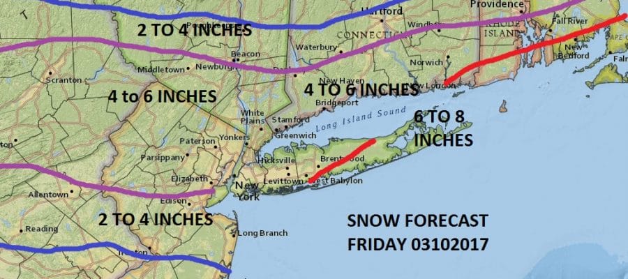
Snow Estimates Raised for Friday 03082017
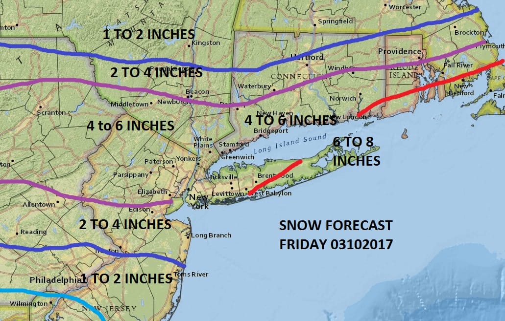
Snow Estimates Raised for Friday 03082017
Weather models tonight have suddenly expanded the extent and amount of snow for late Thursday night into Friday afternoon. The strengthening upper air system is stronger on most of the weather models tonight and even though there is a part of me that really wants to fight this, I think I’m going to give in at this point.
GFS MODEL FRIDAY CLICK TO ANIMATE

As for how this plays out from a weather perspective there are no issues Thursday into Thursday evening as we still have plenty of dry air around so we will have sunshine giving way to arriving clouds with highs in the 50s on Thursday. Then cold air will start coming in Thursday night as northeast winds take over and those winds will pick up some as the night wears on. Some rain and snow will develop after midnight and then literally break out overhead and change to all snow in most areas by daybreak Friday continuing at least into early afternoon. An arctic boundary dropping southward will enhance some snow in the afternoon Friday in some areas as well. Temperatures will settle in the lower 30s and then drop to the teens Saturday morning as skies clear out Friday night. The weekend will be bitter cold with sunshine on Saturday and temperatures won’t get out of the 20s. Sunday we will have sunshine but it will be very cold again with perhaps getting back into the 30s.
SATELLITE LOOP

REGIONAL RADAR

Radars will remain quiet through Thursday evening before precipitation begins to break out and expand.
 GET JOE A CIGAR IF YOU LIKE

SNOW REMOVAL COMPANIES FOR YOUR WINTER NEEDS
LONG ISLAND ROCKLAND COUNTY Connecticut

![]()

ROCKLAND COUNTY TRI STATE SNOW REMOVAL JOHNSTOWN PA


FiOS1 News Weather Forecast For Long Island
FiOS1 News Weather Forecast For New Jersey
FiOS1 News Weather Forecast For Hudson Valley
NATIONAL WEATHER SERVICE SNOW FORECASTS
LATEST JOESTRADAMUS ON THE LONG RANGE
Weather App

Don’t be without Meteorologist Joe Cioffi’s weather app. It is really a meteorologist app because you get my forecasts and my analysis and not some automated computer generated forecast based on the GFS model. This is why your app forecast changes every 6 hours. It is model driven with no human input at all. It gives you an icon, a temperature and no insight whatsoever.
It is a complete weather app to suit your forecast needs. All the weather information you need is right on your phone. Android or I-phone, use it to keep track of all the latest weather information and forecasts. This weather app is also free of advertising so you don’t have to worry about security issues with your device. An accurate forecast and no worries that your device is being compromised.
Use it in conjunction with my website and my facebook and twitter and you have complete weather coverage of all the latest weather and the long range outlook. The website has been redone and upgraded. Its easy to use and everything is archived so you can see how well Joe does or doesn’t do when it comes to forecasts and outlooks.
Just click on the google play button or the apple store button on the sidebar for my app which is on My Weather Concierge. Download the app for free. Subscribe to my forecasts on an ad free environment for just 99 cents a month.
Get my forecasts in the palm of your hand for less than the cost of a cup of Joe!


